
MapOnMap
বিজ্ঞাপনযুক্ত

১০ হাজাৰ+
ডাউনল’ড

সকলো
info


এই এপ্টোৰ বিষয়ে
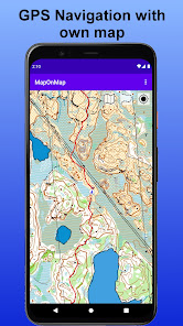
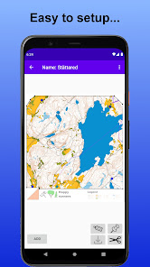
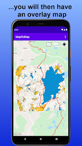
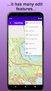
MapOnMap is a tool where you can place your high detailed hiking map on top of an online map, i.e. an Overlay Map.
I have found it useful to have a tool, where I'm able to photograph a map, which I can navigate with the phone's GPS. It could be a map on an information board, a tourist guide map or a hiking map etc.
MapOnMap also supports Track Navigation. With MapOnMap you can record and navigate with GPX-tracks. It also supports Track Geofence, which means that you get a voice notification if you get too far off the track. GPX-tracks is a standard format for describing tracks and can often be found on hiking sites.
These two main features makes it a perfect hiking navigation tool.
আপডে’ট কৰা তাৰিখ
বিকাশকৰ্তাসকলে আপোনাৰ ডেটা কেনেকৈ সংগ্ৰহ আৰু শ্বেয়াৰ কৰে সেয়া বুজি পোৱাৰ জৰিয়তে সুৰক্ষা আৰম্ভ হয়। ডেটাৰ গোপনীয়তা আৰু সুৰক্ষা প্ৰণালী আপোনাৰ ব্যৱহাৰ, অঞ্চল আৰু বয়সৰ ওপৰত ভিত্তি কৰি ভিন্ন হ’ব পাৰে। বিকাশকৰ্তাগৰাকীয়ে এই তথ্যখিনি প্ৰদান কৰিছে আৰু সময়ৰ লগে লগে এয়া আপডে’ট কৰিব পাৰে।


নতুন কি আছে
Migrate to Android 16 (API-level 36).
Remove dependency to READ_MEDIA_IMAGES permission.
Remove dependency to READ_MEDIA_IMAGES permission.
এপৰ সমৰ্থন
বিকাশকৰ্তাৰ বিষয়ে
Sven Gunnar Mattias Nilsson
mattias.s.nilsson@gmail.com
Sweden
undefined


