
SDDOT 511
3.2star
330 Rezensionen
Regierung
info
100 Tsg.+
Downloads

Jedes Alter
info

Über diese App
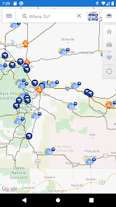
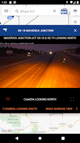
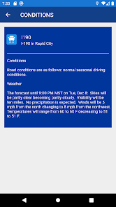
The SDDOT 511 mobile application provides real-time access to traveler information supplied by the South Dakota Department of Transportation (SDDOT). Maps depict current roadway conditions and the latest incident, construction, and restriction information on all Interstate, U.S., and State Routes. Forecasted road condition threats for the upcoming 24 hours are described in the road segment reports, and where there are such threats may be viewed on the map. The maps also indicate the location of roadside cameras and allow the user to view camera images. As the user moves through the highway network, the app keeps track of the user’s location on the map. SDDOT also maintains a Twitter feed accessible through the 511 mobile application's main menu. Finally, the mobile application links surrounding states' mobile applications and mobile websites.
Powered by ClearRoute™
Powered by ClearRoute™
Aktualisiert am
Was die Sicherheit angeht, solltest du als Erstes verstehen, wie Entwickler deine Daten erheben und weitergeben. Die Datenschutz- und Sicherheitspraktiken können je nach deiner Verwendung, deiner Region und deinem Alter variieren. Diese Informationen wurden vom Entwickler zur Verfügung gestellt und können jederzeit von ihm geändert werden.

Keine Daten werden mit Drittunternehmen oder -organisationen geteilt

Diese App kann die folgenden Datentypen erheben
Standort und App-Informationen und -Leistung

Daten werden bei der Übertragung verschlüsselt

Daten können nicht gelöscht werden
Bewertungen und Rezensionen
3.2
320 Rezensionen
Neuerungen
App defaults to user location at startup.
Support für diese App
Informationen zum Entwickler
Iteris, Inc.
helpdesk@iteris.com
1250 S Capital Of Texas Hwy Bldg 1-330
West Lake Hills, TX 78746
United States
+1 949-270-9435


