
SDDOT 511
3.2star
330ଟି ସମୀକ୍ଷା
ସରକାର
info
100ହ+
ଡାଉନଲୋଡ

ସମସ୍ତେ
info

ଏହି ଆପ୍ ବିଷୟରେ
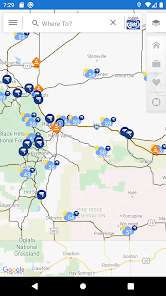
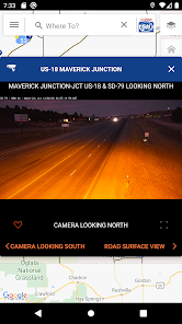
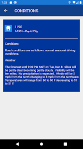
The SDDOT 511 mobile application provides real-time access to traveler information supplied by the South Dakota Department of Transportation (SDDOT). Maps depict current roadway conditions and the latest incident, construction, and restriction information on all Interstate, U.S., and State Routes. Forecasted road condition threats for the upcoming 24 hours are described in the road segment reports, and where there are such threats may be viewed on the map. The maps also indicate the location of roadside cameras and allow the user to view camera images. As the user moves through the highway network, the app keeps track of the user’s location on the map. SDDOT also maintains a Twitter feed accessible through the 511 mobile application's main menu. Finally, the mobile application links surrounding states' mobile applications and mobile websites.
Powered by ClearRoute™
Powered by ClearRoute™
ଗତ ଅପଡେଟର ସମୟ
ଡେଭେଲପରମାନେ ଆପଣଙ୍କ ଡାଟାକୁ କିପରି ସଂଗ୍ରହ ଏବଂ ସେୟାର କରନ୍ତି ସେହି ଧାରଣା ସହିତ ସୁରକ୍ଷା ଆରମ୍ଭ ହୁଏ। ଆପଣଙ୍କ ବ୍ୟବହାର, ଅଞ୍ଚଳ ଏବଂ ବୟସ ଆଧାରରେ, ଡାଟା ଗୋପନୀୟତା ଓ ସୁରକ୍ଷା ପ୍ରାକ୍ଟିସ ଭିନ୍ନ ହୋଇପାରେ। ଡେଭେଲପର ଏହି ସୂଚନା ପ୍ରଦାନ କରିଛନ୍ତି ଏବଂ ସେ ସମୟାନୁସାରେ ଏହାକୁ ଅପଡେଟ କରିପାରନ୍ତି।

ତୃତୀୟ ପକ୍ଷଗୁଡ଼ିକ ସହ କୌଣସି ଡାଟା ସେୟାର କରାଯାଇନାହିଁ
ଡେଭେଲପରମାନେ କିପରି ସେୟାରିଂର ଘୋଷଣା କରନ୍ତି ସେ ବିଷୟରେ ଅଧିକ ଜାଣନ୍ତୁ

ଏହି ଆପ ଏହି ପ୍ରକାର ଡାଟା ସଂଗ୍ରହ କରିପାରେ
ଲୋକେସନ ଓ ଆପ ସୂଚନା ଏବଂ ପରଫରମାନ୍ସ

ଟ୍ରାଞ୍ଜିଟ ସମୟରେ ଡାଟା ଏନକ୍ରିପ୍ଟ କରାଯାଇଥାଏ

ଡାଟା ଡିଲିଟ କରାଯାଇପାରିବ ନାହିଁ
ମୂଲ୍ୟାଙ୍କନ ଓ ସମୀକ୍ଷା
3.2
320ଟି ସମୀକ୍ଷା
ନୂଆ କଣ ଅଛି
App defaults to user location at startup.
ଆପ ସପୋର୍ଟ
ଡେଭେଲପରଙ୍କ ବିଷୟରେ
Iteris, Inc.
helpdesk@iteris.com
1250 S Capital Of Texas Hwy Bldg 1-330
West Lake Hills, TX 78746
United States
+1 949-270-9435


