Doppler storm radar - eMap HDF
광고 포함인앱 구매
4.5star
리뷰 5.7천개
10만+
다운로드

전체이용가
info


앱 정보
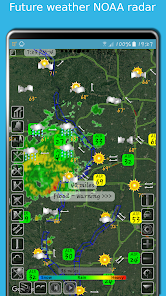
eMap HDF is a high-resolution predictive NOAA Doppler storm radar with a weather map.
The weather app has the next layers provided by the National Weather Service (NWS) & NOAA:
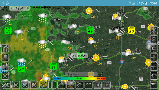
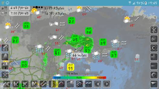
- Snow and rain radar
- Severe weather alerts, tornado tracker, heavy rain and wind alerts
- Lightning strike map
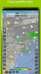
- Cloud satellite layer
Worldwide layers:
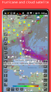
- Typhoon (tropical storm, cyclone) and hurricane tracker provided by GDACS
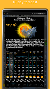
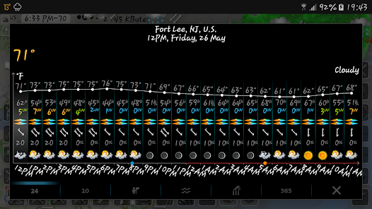
- Accurate weather forecast for 10 days
- Hourly weather forecast for 24 hours
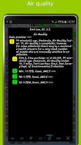
- Air quality and air pollution
- Earthquake map
- Temperature map
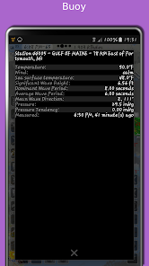
- Sea temperature based on measurements from buoys and satellites
- Tide charts
- Local time in each city
- Number of residents in cities
- Road traffic
- Buoys
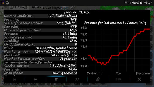
- Dew point
- Humidity
- Wind map
The storm radar app calculates a one-hour prediction of rain and snow in five-minute frames. NOAA radar has a six-hour weather radar history.
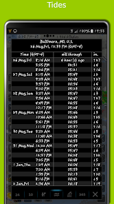
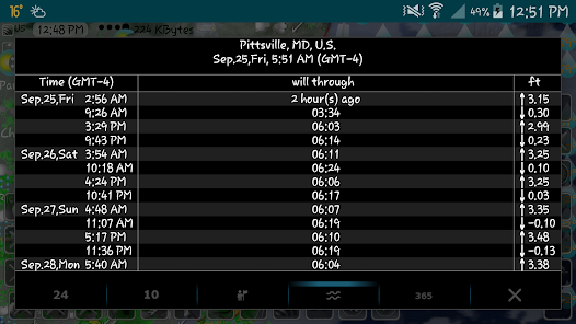
Tide times are for over 10,000 tidal stations in the US, UK, Canada, etc. with forecasts for several months. The app follows the current location and shows the tides near me.
The earthquake app includes earthquakes filtered by magnitude and depth. Earthquake tracker data is provided by the USGS.
The distance measurement tool shows the distance between two points in miles and kilometres.
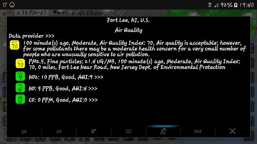
The air quality app includes concentrations of ozone (O3), fine (PM25) and coarse (PM10), particulate matter, dioxide (NO2) and nitrogen oxide (NO), carbon monoxide (CO), etc. from various sources: AirNow, Copernicus, ECMWF, etc.
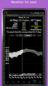
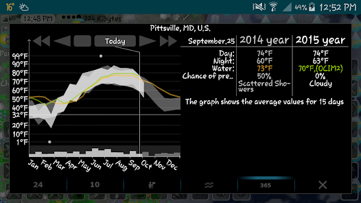
With the Doppler radar app, you can long-click on any location on the map and see the weather at that location with the archive for the last few years. The archive includes sea and air temperature, precipitation and cloud cover. Travel weather helps you choose the right time and place for your upcoming trip and compare temperatures and precipitation between this year and past years.
If you click on the "CC" button and toggle to "10" or "24", you can view a 10-day or 24-hour forecast directly on the map.
eMap HDF shows road traffic. The forecast includes not only temperature and precipitation, but also humidity, wind speed and direction, dew point, visibility on the roads feels like temperature.
As the data published in eMap HDF is not subject to use on the voyage, please do not use it for navigation.
The weather app has the next layers provided by the National Weather Service (NWS) & NOAA:
- Snow and rain radar
- Severe weather alerts, tornado tracker, heavy rain and wind alerts
- Lightning strike map
- Cloud satellite layer
Worldwide layers:
- Typhoon (tropical storm, cyclone) and hurricane tracker provided by GDACS
- Accurate weather forecast for 10 days
- Hourly weather forecast for 24 hours
- Air quality and air pollution
- Earthquake map
- Temperature map
- Sea temperature based on measurements from buoys and satellites
- Tide charts
- Local time in each city
- Number of residents in cities
- Road traffic
- Buoys
- Dew point
- Humidity
- Wind map
The storm radar app calculates a one-hour prediction of rain and snow in five-minute frames. NOAA radar has a six-hour weather radar history.
Tide times are for over 10,000 tidal stations in the US, UK, Canada, etc. with forecasts for several months. The app follows the current location and shows the tides near me.
The earthquake app includes earthquakes filtered by magnitude and depth. Earthquake tracker data is provided by the USGS.
The distance measurement tool shows the distance between two points in miles and kilometres.
The air quality app includes concentrations of ozone (O3), fine (PM25) and coarse (PM10), particulate matter, dioxide (NO2) and nitrogen oxide (NO), carbon monoxide (CO), etc. from various sources: AirNow, Copernicus, ECMWF, etc.
With the Doppler radar app, you can long-click on any location on the map and see the weather at that location with the archive for the last few years. The archive includes sea and air temperature, precipitation and cloud cover. Travel weather helps you choose the right time and place for your upcoming trip and compare temperatures and precipitation between this year and past years.
If you click on the "CC" button and toggle to "10" or "24", you can view a 10-day or 24-hour forecast directly on the map.
eMap HDF shows road traffic. The forecast includes not only temperature and precipitation, but also humidity, wind speed and direction, dew point, visibility on the roads feels like temperature.
As the data published in eMap HDF is not subject to use on the voyage, please do not use it for navigation.
업데이트 날짜


평점 및 리뷰
4.6
리뷰 4.98천개

Google 사용자
- 부적절한 리뷰로 신고
- 리뷰 기록 표시
2018년 11월 14일
전세계 날씨, 시간, 인구 등 아주 많은 정보를 한눈에 제공하는 훌륭한 앱입니다. 옵션 사용법이 처음 접하는 사람에게 복잡할 수 있지만 익숙해지면 정말 좋습니다.
사용자 6명이 이 리뷰가 유용하다고 평가함
Elecont software
2018년 11월 14일
고맙습니다. 우리의 목표는 스크롤없이 하나의 창에 필요한 모든 정보를 표시하는 응용 프로그램입니다.

김동규
- 부적절한 리뷰로 신고
2020년 8월 1일
eWeather HDF 어플은 현재 위치 기준으로 날씨를 자세히 알려준다면 이 어플은 다른 지역, 나라 날씨까지 전부 알수있는 어플이어서 더 좋네요~ 각자 상황에 맞게 사용하면 될듯합니다!
사용자 1명이 이 리뷰가 유용하다고 평가함
Elecont software
2020년 8월 1일
감사합니다. eMap HDF를 사용하면지도에서 임의의 장소를 길게 클릭하고이 장소의 날씨를 표시 할 수 있습니다. "CC"버튼을 클릭하고 "10"또는 "24"로 전환하면 10 일 또는 24 시간 예측을지도에 직접 표시 할 수 있습니다. eMap HDF는 인구 및 도로 교통량을 표시 할 수 있습니다.

신아
- 부적절한 리뷰로 신고
2024년 8월 17일
첫째 고객 질의 시 신속한 응답과 함께 문제 해결 둘째 많은 옵션을 이용하여 개인이 원하는 정보를 얻기 위해 설정하는 과정이 처음에는 다소 낯설지만 그만큼 원하는 정보를 습득할 수 있어 좋습니다
Elecont software
2024년 8월 17일
감사합니다. 17년 동안 앱을 개발하면서 많은 날씨와 환경 데이터를 추가했습니다. 하지만 여전히 앱에 새롭고 흥미로운 데이터를 추가할 수 있는 아이디어가 많이 있습니다.
새로운 기능
엣지 투 엣지 디스플레이 기능
일부 버그 수정
사용자 인터페이스 개선
일부 버그 수정
사용자 인터페이스 개선
앱 지원
개발자 소개
Сергей Барвиненко
elecontsoftware@gmail.com
ул. Савушкина, дом 54
71
Санкт-Петербург
Russia
197183
undefined


