
iFly EFB
Kupovina unutar aplikacije
4,6star
554 recenzije
50 hilj.+
Preuzimanja

Svako
info


O aplikaciji
A Better Way to Navigate
iFly EFB offers unmatched value, powerful features, and intuitive usability for both VFR and IFR pilots. Quickly access the critical information you need so you can focus on what matters most: Flying.
Free 30-Day Trial
Try iFly EFB free for 30 days. No commitment — just fly and explore.
Requirements: Android 9.0 or higher, and 1GB+ of storage.
------------------------------------------------------------------
Core Features
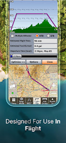
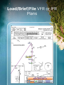
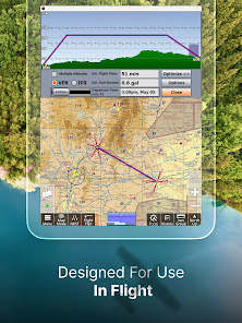
Flight Planning
Create simple direct-to or multi-waypoint routes directly on FAA charts, vector maps, or the Flight Plan page. Use drag-and-drop rubber-band routing to adjust your path in seconds. Patented RealPlan Automated VFR Flight Planning makes Cross Country planning a breeze.
Designed for General Aviation Pilots
iFly EFB is designed for General Aviation pilots: With large buttons and high contrast maps, iFly EFB supports you with quick access to information and data so you can stay focused on flying the aircraft.
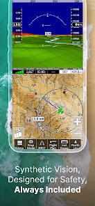
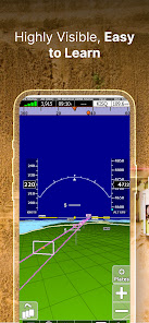
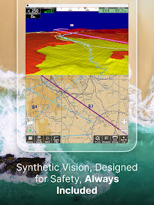
Synthetic Vision + 3D Traffic
See terrain and traffic in 3D to maximize situational awareness — works seamlessly on both phones and tablets.
Active Alerting System
Receive real-time alerts for airspace, terrain, traffic alert callouts, and more to keep you situationally aware.
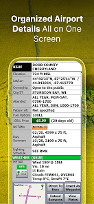
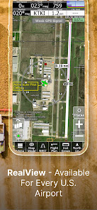
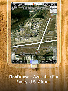
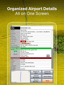
RealView Airports + AutoTaxi+
Satellite imagery for 12,600+ airports gives you visual familiarity before you land. AutoTaxi+ helps guide you safely on the ground.
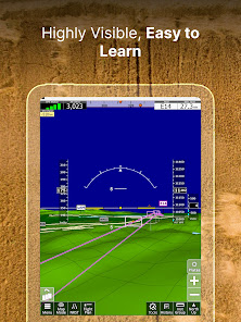
Instruments Layouts
Simulates real cockpit instruments using GPS or third-party AHRS (e.g., HSI, VSI, Altimeter, Turn Indicator). Add an AHRS for an artificial horizon with attitude alerts.
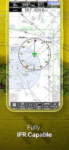
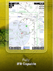
Full US VFR/IFR Chart Access
Includes geo-referenced Sectionals, TACs, Low & High Enroute charts, approach plates, airport diagrams, and more.
Private & Public Airport Support
Tap into FAA-updated databases for public/private airports. Add your own custom waypoints for unmapped locations.
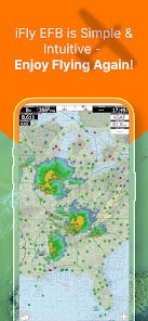
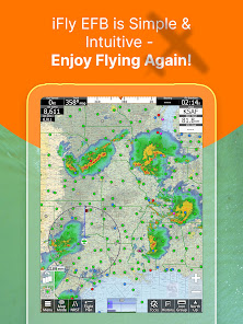
Aviation Weather Tools
Access pre-flight weather overlays with visual VFR/IFR data. Tap for detailed METARs, TAFs, and Winds Aloft.
ADS-B IN Support
Connect to iLevil, Stratus, uAvionix, Stratux, and many other ADS-B receivers for live weather and traffic — no extra cost.
------------------------------------------------------------------
Simple Subscriptions
VFR: All the core features for VFR Pilots, no paywalls for the features you need
IFR: Adds advanced tools for instrument-rated flying
The base subscription supports two Android devices. Upgrade to Multiplatform to use up to four devices across platforms.
------------------------------------------------------------------
Feature List
Map Layers:
• Sectionals, WAC, TAC
• Low/High-Enroute
• Vector Base Maps
• Geo-Referenced Plates & Diagrams
Map Modes:
• METARS, AIRMETS, NEXRAD, TAF
• Forecast (Clouds, Flight Conditions, etc.)
• Winds Aloft
• Glide Range Rings
• Terrain Highlights
• Fuel Prices
• Obstructions
Dynamic Overlays:
• Synthetic Vision with 3D Traffic
• Terrain, Obstructions, and Fuel Prices
• FAA Approach Plates
Tools & Interface:
• RealPlan: Automated VFR flight planning
• Instruments panel with 24+ layouts (incl. HSI, AHRS, vertical profile)
• Weight & Balance
• Checklists
• NOTAM Viewer
• Fly Direct-To
• Vertical Profile with Altitudes, Clouds, Flight Conditions, Airspaces, etc.
• Save/load flight plans & waypoints
• Emergency "Find Nearest" button
• Map orientation: North Up / Track Up
• Touch/pinch zoom & single-tap tools
• Day/Night mode & fading buttons
• Custom alerts (Terrain, Traffic, Airspace, Oxygen, Flight Plan)
• Custom waypoints
• Customizable instrument layouts
• Compatible with Microsoft Flight Simulator & X-Plane
iFly EFB offers unmatched value, powerful features, and intuitive usability for both VFR and IFR pilots. Quickly access the critical information you need so you can focus on what matters most: Flying.
Free 30-Day Trial
Try iFly EFB free for 30 days. No commitment — just fly and explore.
Requirements: Android 9.0 or higher, and 1GB+ of storage.
------------------------------------------------------------------
Core Features
Flight Planning
Create simple direct-to or multi-waypoint routes directly on FAA charts, vector maps, or the Flight Plan page. Use drag-and-drop rubber-band routing to adjust your path in seconds. Patented RealPlan Automated VFR Flight Planning makes Cross Country planning a breeze.
Designed for General Aviation Pilots
iFly EFB is designed for General Aviation pilots: With large buttons and high contrast maps, iFly EFB supports you with quick access to information and data so you can stay focused on flying the aircraft.
Synthetic Vision + 3D Traffic
See terrain and traffic in 3D to maximize situational awareness — works seamlessly on both phones and tablets.
Active Alerting System
Receive real-time alerts for airspace, terrain, traffic alert callouts, and more to keep you situationally aware.
RealView Airports + AutoTaxi+
Satellite imagery for 12,600+ airports gives you visual familiarity before you land. AutoTaxi+ helps guide you safely on the ground.
Instruments Layouts
Simulates real cockpit instruments using GPS or third-party AHRS (e.g., HSI, VSI, Altimeter, Turn Indicator). Add an AHRS for an artificial horizon with attitude alerts.
Full US VFR/IFR Chart Access
Includes geo-referenced Sectionals, TACs, Low & High Enroute charts, approach plates, airport diagrams, and more.
Private & Public Airport Support
Tap into FAA-updated databases for public/private airports. Add your own custom waypoints for unmapped locations.
Aviation Weather Tools
Access pre-flight weather overlays with visual VFR/IFR data. Tap for detailed METARs, TAFs, and Winds Aloft.
ADS-B IN Support
Connect to iLevil, Stratus, uAvionix, Stratux, and many other ADS-B receivers for live weather and traffic — no extra cost.
------------------------------------------------------------------
Simple Subscriptions
VFR: All the core features for VFR Pilots, no paywalls for the features you need
IFR: Adds advanced tools for instrument-rated flying
The base subscription supports two Android devices. Upgrade to Multiplatform to use up to four devices across platforms.
------------------------------------------------------------------
Feature List
Map Layers:
• Sectionals, WAC, TAC
• Low/High-Enroute
• Vector Base Maps
• Geo-Referenced Plates & Diagrams
Map Modes:
• METARS, AIRMETS, NEXRAD, TAF
• Forecast (Clouds, Flight Conditions, etc.)
• Winds Aloft
• Glide Range Rings
• Terrain Highlights
• Fuel Prices
• Obstructions
Dynamic Overlays:
• Synthetic Vision with 3D Traffic
• Terrain, Obstructions, and Fuel Prices
• FAA Approach Plates
Tools & Interface:
• RealPlan: Automated VFR flight planning
• Instruments panel with 24+ layouts (incl. HSI, AHRS, vertical profile)
• Weight & Balance
• Checklists
• NOTAM Viewer
• Fly Direct-To
• Vertical Profile with Altitudes, Clouds, Flight Conditions, Airspaces, etc.
• Save/load flight plans & waypoints
• Emergency "Find Nearest" button
• Map orientation: North Up / Track Up
• Touch/pinch zoom & single-tap tools
• Day/Night mode & fading buttons
• Custom alerts (Terrain, Traffic, Airspace, Oxygen, Flight Plan)
• Custom waypoints
• Customizable instrument layouts
• Compatible with Microsoft Flight Simulator & X-Plane
Ažurirano dana
Sigurnost počinje razumijevanjem na koji način programeri prikupljaju i dijele vaše podatke. Privatnost podataka i sigurnosne prakse se mogu razlikovati ovisno o korištenju, regiji i dobi. Programer je naveo ove informacije i može ih s vremenom ažurirati.


Ocjene i recenzije
4,5
368 recenzija
Što je novo
Patch-fix for application crash that sporadically occurred on some Android devices. Otherwise, this release is the same as prior 13.3.54 release from a couple weeks ago.
Podrška za aplikaciju
Informacije o programeru
Adventure Pilot, LLC
walter@adventurepilot.com
1476 Industrial Blvd Ste 200
McKinney, TX 75069
United States
+1 214-729-9049


