
2GIS: Offline map & navigation
Contains ads
4.7star
1.44M reviews
100M+
Downloads

Rated for 3+
info


About this app
2GIS is a detailed map with GPS-navigation for car drivers and pedestrians, live traffic map, transit schedules, and a full city directory. Use it online or download the map to your device to never get lost without an internet connection.
With 2GIS’s maps and navigation, you will feel at home even in an unfamiliar place:
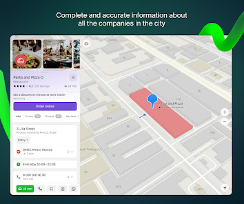
— easily find the address, company, phone number, working hours, goods or services;
— find out how to get there by car, bus, subway, or follow the navigator on foot;
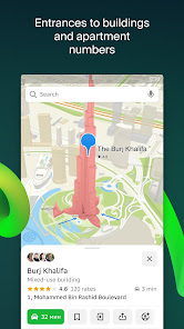
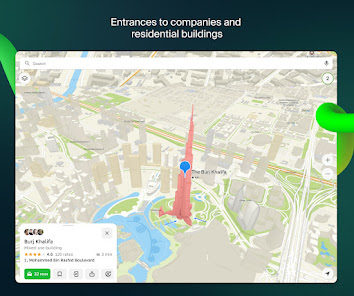
— find an entrance to a building and a parking lot nearby.
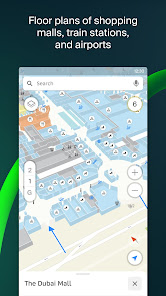
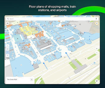
Accurate maps. Locate districts, buildings, streets, bus stops, subway stations, gas stations, sports grounds, and other objects.
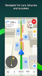
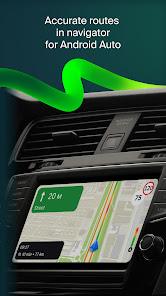
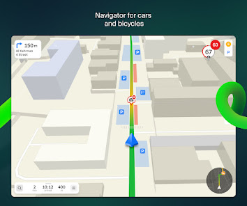
GPS-navigation. Considers real-time traffic jams, signs, speed cameras, toll and unpaved roads, builds routes between cities and through several points. There is also a free app for Android Auto.
Road events. Reports of accidents, blocked streets, and speed cameras, user comments — everything is right on the map.
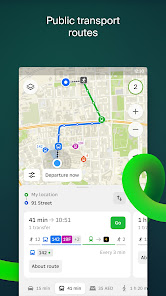
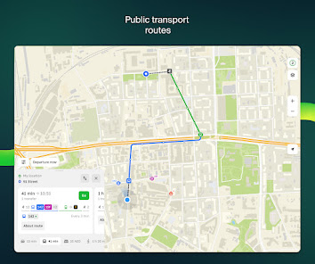
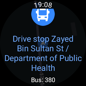
Public transport. 2GIS knows the timetable and online routes of public transit.
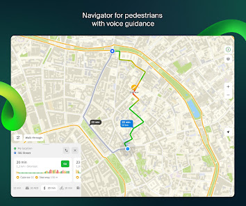
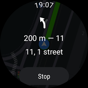
Walking routes. Pedestrian navigation paves the way wherever you can go on foot. Works in the background, supports voice guidance.
Navigation for trucks. Cargo navigator gets directions for trucks considering the individual characteristics of vehicles and cargo.
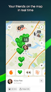
Friends on the map. Now you can find your friends and kids on the map! 2GIS shows the real-time location of your friends. You decide who to add as friends and who will see your location. Manage your visibility in the settings.
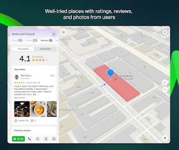
Detailed directory. 2GIS shows addresses, entrances, and postal codes. 2GIS knows phone numbers, working hours, social networks, websites, and entrance locations. Users add photos of companies and write reviews.
Travel guide. Find out about the main attractions, places with Wi-Fi, and more on the map.
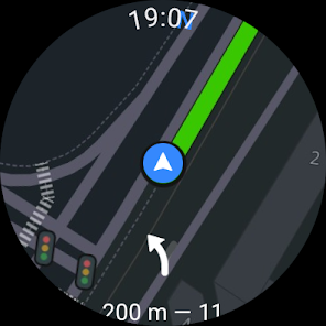
A 2GIS Notifications companion app for smart watches on Wear OS. A handy tool for navigating routes on foot, by bike or by public transport from the main 2GIS app: view the map, get manoeuver hints and get vibration alerts when approaching a turn or a destination bus stop. The companion starts automatically when you start navigation on your phone. Available for Wear OS 3.0 or later versions.
Available maps:
Cities of the UAE:
Dubai, Sharjah, Abu Dhabi, Al Ain, Ajam, Ras Al Khaimah, Fujairah, Umm Al Quwain, Dibba Al Fujairah, Khor Fakkan, Kalba, Al Salamh, ect.
Cities of Russia:
Moscow, Saint Petersburg, Novosibirsk, Ekaterinburg, Krasnoyarsk, Chelyabinsk, Ufa, Omsk, Kazan, Perm, Nizhny Novgorod, Sheregesh, etc.
Cities of Belarus, Kazakhstan, Uzbekistan, Azerbaijan and Kyrgyzstan:
Minsk, Pavlodar, Semey, Aktau, Aktobe, Almaty, Nur-Sultan, Bishkek, Karaganda, Kokshetau, Kostanay, Osh, Baku, Tashkent, etc.
Support: dev@2gis.com
With 2GIS’s maps and navigation, you will feel at home even in an unfamiliar place:
— easily find the address, company, phone number, working hours, goods or services;
— find out how to get there by car, bus, subway, or follow the navigator on foot;
— find an entrance to a building and a parking lot nearby.
Accurate maps. Locate districts, buildings, streets, bus stops, subway stations, gas stations, sports grounds, and other objects.
GPS-navigation. Considers real-time traffic jams, signs, speed cameras, toll and unpaved roads, builds routes between cities and through several points. There is also a free app for Android Auto.
Road events. Reports of accidents, blocked streets, and speed cameras, user comments — everything is right on the map.
Public transport. 2GIS knows the timetable and online routes of public transit.
Walking routes. Pedestrian navigation paves the way wherever you can go on foot. Works in the background, supports voice guidance.
Navigation for trucks. Cargo navigator gets directions for trucks considering the individual characteristics of vehicles and cargo.
Friends on the map. Now you can find your friends and kids on the map! 2GIS shows the real-time location of your friends. You decide who to add as friends and who will see your location. Manage your visibility in the settings.
Detailed directory. 2GIS shows addresses, entrances, and postal codes. 2GIS knows phone numbers, working hours, social networks, websites, and entrance locations. Users add photos of companies and write reviews.
Travel guide. Find out about the main attractions, places with Wi-Fi, and more on the map.
A 2GIS Notifications companion app for smart watches on Wear OS. A handy tool for navigating routes on foot, by bike or by public transport from the main 2GIS app: view the map, get manoeuver hints and get vibration alerts when approaching a turn or a destination bus stop. The companion starts automatically when you start navigation on your phone. Available for Wear OS 3.0 or later versions.
Available maps:
Cities of the UAE:
Dubai, Sharjah, Abu Dhabi, Al Ain, Ajam, Ras Al Khaimah, Fujairah, Umm Al Quwain, Dibba Al Fujairah, Khor Fakkan, Kalba, Al Salamh, ect.
Cities of Russia:
Moscow, Saint Petersburg, Novosibirsk, Ekaterinburg, Krasnoyarsk, Chelyabinsk, Ufa, Omsk, Kazan, Perm, Nizhny Novgorod, Sheregesh, etc.
Cities of Belarus, Kazakhstan, Uzbekistan, Azerbaijan and Kyrgyzstan:
Minsk, Pavlodar, Semey, Aktau, Aktobe, Almaty, Nur-Sultan, Bishkek, Karaganda, Kokshetau, Kostanay, Osh, Baku, Tashkent, etc.
Support: dev@2gis.com
Updated on
Safety starts with understanding how developers collect and share your data. Data privacy and security practices may vary based on your use, region, and age. The developer provided this information and may update it over time.

No data shared with third parties
Learn more about how developers declare sharing

This app may collect these data types
Personal info, Photos and videos, and Contacts

Data is encrypted in transit

You can request that data be deleted
Ratings and reviews
4.7
1.37M reviews

A Google user
- Flag inappropriate
- Show review history
December 16, 2018
I mean, I love the app. Very helpful. But after the update, maybe you could have made the font even smaller? As in actually 0.1 of mm? It is impossible to read without smashing the screen directly into the face. It is rather disappointing that you don't think about people with eyesight impairments and there is even no feature to change the text size.
63 people found this review helpful

Diana Pestova
- Flag inappropriate
November 1, 2022
This used to be the perfect offline app for me. Before a surge of updates started. With lots of unnecessary information, with forced download of the world map (why???), as a result it takes an eternity to open the app (no, I am not going to buy a phone with a better performance). Make it possible to choose what kind of information I need. There are too many details these days, personally me using but a mere 20-30% of it.
90 people found this review helpful

Modi Alyan
- Flag inappropriate
July 18, 2024
TERRIBLE!!! Never even once took me to the right destination. Every time I use it, it takes me somewhere else at least 100m away, then recalculate, then again wrong direction. As well as it says right when supposed to be left and left when supposed to be right. Don't know if this is only for the English voice or it's like this in Russian as well. Always takes longer rout, and doesn't like when I take a shortcut! All other navigators are way better, just wasted my time with it. Uninstall
2GIS
July 18, 2024
We are really disappointed to hear that you were dissatisfied with our app 😔 It would be helpful for us to receive more detailed feedback. Please contact us via “Report a bug" button in the card of the route. It will help us to check the data for any mistakes and fix it.
What's new
June update!
Friends on the map:
— New action notifications now show friends' avatars.
— After adding a new friend, you'll see a list of your mutual acquaintances.
Transport:
— Share routes from the navigator: use the button above the search results or under the detailed description of the route.
— Added a forecast of bus arrivals to route construction screen.
— Now you can choose which modes of transport to display in the “Transport” layer.


