Ember Map
এপৰ ভিতৰত ক্ৰয় সুবিধা
১০০+
ডাউনল’ড

সকলো
info


এই এপ্টোৰ বিষয়ে
Ember Map: The Ultimate Fireground Mapping & Navigation App for Bushfire Fighters
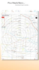
Ember Map is a cutting-edge mapping and navigation app designed specifically for use on the fireground by bushfire fighters. This powerful tool provides up-to-date satellite hotspots, GPS tracking, topographic maps, and more to help you stay informed and enhance your situational awareness on the fireground.
APP FEATURES
- Import and view GeoPDF files.
- Fire behaviour calculators.
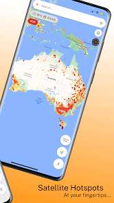
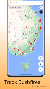
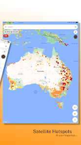
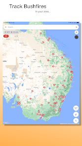
- Real-time Satellite Hotspots: Stay updated with the latest hotspots for effective firefighting strategies and better situational awareness.
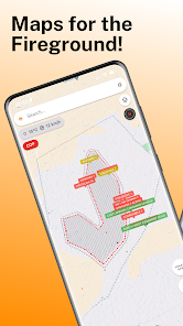
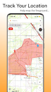
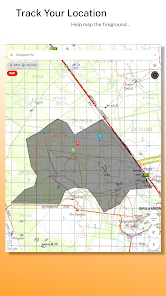
- GPS Location Tracking: Map out the fireground and backtrack easily with GPS location tracking.
- Comprehensive TOPO Maps: Access invaluable information, including property names and tracks, not available on standard maps.
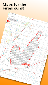
- Save and Annotate Map Items: Save polygons, polylines, and markers, and add notes for future reference.
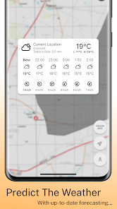
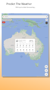
- Built-in Weather Viewer: Stay informed with the latest weather conditions to make informed decisions on the ground.
- Measure Tools: Quickly measure perimeter, area, and radius for accurate assessment and planning.
- Automatic Map Caching: Use maps offline with automatic caching, ensuring you have the information you need even without an internet connection.
EMBER MAP PRO
Unlock the full potential of Ember Map with Ember Map Pro, offering unlimited saved items, premium support, and advanced features like Hotspots and NSW RFS integration. Enjoy an ad-free experience and support the continued development of Ember Map.
CONTACT US
Website: https://reddirtsolutions.com.au/
Facebook: https://www.facebook.com/RedDirtSolutions
LEGAL
Terms of Use: https://reddirtsolutions.com.au/about-us/terms-of-use
Privacy Policy: https://reddirtsolutions.com.au/about-us/privacy-policy
SUPPORT
For any support inquiries, please email us at support@reddirtsolutions.com.au
Experience the power of Ember Map and revolutionize your firefighting experience today. Download now and join the ranks of bushfire fighters who trust Ember Map for their mapping and navigation needs.
Ember Map is a cutting-edge mapping and navigation app designed specifically for use on the fireground by bushfire fighters. This powerful tool provides up-to-date satellite hotspots, GPS tracking, topographic maps, and more to help you stay informed and enhance your situational awareness on the fireground.
APP FEATURES
- Import and view GeoPDF files.
- Fire behaviour calculators.
- Real-time Satellite Hotspots: Stay updated with the latest hotspots for effective firefighting strategies and better situational awareness.
- GPS Location Tracking: Map out the fireground and backtrack easily with GPS location tracking.
- Comprehensive TOPO Maps: Access invaluable information, including property names and tracks, not available on standard maps.
- Save and Annotate Map Items: Save polygons, polylines, and markers, and add notes for future reference.
- Built-in Weather Viewer: Stay informed with the latest weather conditions to make informed decisions on the ground.
- Measure Tools: Quickly measure perimeter, area, and radius for accurate assessment and planning.
- Automatic Map Caching: Use maps offline with automatic caching, ensuring you have the information you need even without an internet connection.
EMBER MAP PRO
Unlock the full potential of Ember Map with Ember Map Pro, offering unlimited saved items, premium support, and advanced features like Hotspots and NSW RFS integration. Enjoy an ad-free experience and support the continued development of Ember Map.
CONTACT US
Website: https://reddirtsolutions.com.au/
Facebook: https://www.facebook.com/RedDirtSolutions
LEGAL
Terms of Use: https://reddirtsolutions.com.au/about-us/terms-of-use
Privacy Policy: https://reddirtsolutions.com.au/about-us/privacy-policy
SUPPORT
For any support inquiries, please email us at support@reddirtsolutions.com.au
Experience the power of Ember Map and revolutionize your firefighting experience today. Download now and join the ranks of bushfire fighters who trust Ember Map for their mapping and navigation needs.
আপডে’ট কৰা তাৰিখ
বিকাশকৰ্তাসকলে আপোনাৰ ডেটা কেনেকৈ সংগ্ৰহ আৰু শ্বেয়াৰ কৰে সেয়া বুজি পোৱাৰ জৰিয়তে সুৰক্ষা আৰম্ভ হয়। ডেটাৰ গোপনীয়তা আৰু সুৰক্ষা প্ৰণালী আপোনাৰ ব্যৱহাৰ, অঞ্চল আৰু বয়সৰ ওপৰত ভিত্তি কৰি ভিন্ন হ’ব পাৰে। বিকাশকৰ্তাগৰাকীয়ে এই তথ্যখিনি প্ৰদান কৰিছে আৰু সময়ৰ লগে লগে এয়া আপডে’ট কৰিব পাৰে।


নতুন কি আছে
- New free maps added for New Zealand Topographic, OpenStreetMap and NSW Street.
- Premium Maps Added including worldwide topographic maps.
- Add your own custom map overlays using a map tile server url.
- Map overlay transparency is now adjustable.
- Premium Maps Added including worldwide topographic maps.
- Add your own custom map overlays using a map tile server url.
- Map overlay transparency is now adjustable.


