
Costa del Sol offline map
10+
Downloads

Everyone
info

About this app
Offline map of the Costa del Sol in Spain for tourist and business visitors. Download the app before you go or using your hotel's Wi-Fi and avoid expensive roaming charges. The map runs completely on your device; map display with pan and infinite zoom, routing, searching, everything. It does not use your data connection at all. Switch your phone function off if you want to.
No ads. All features fully functional, no extra downloads, no "in app purchases" required.
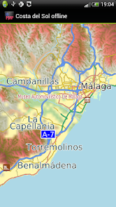
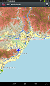
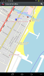
The map includes Marbella, Torremolinos, Málaga, Malaga Airport, Torre del Mar, Fuengirola and the entire province if you fancy a day away from the beach. It is based on OpenStreetMap data, http://www.openstreetmap.org.
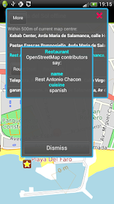
What is good in Costal del Sol: Roads, tracks, airports, beaches, things to do and see appear well mapped. Coverage of hotels is reasonable.
What is not so good: Detailed point of interest. There is coverage of some tourist eating places and amenities like hospitals, banks along the coast but it is not complete. There are almost no doctors mapped. Some residential and smaller roads lack names. You can help improve it by becoming an OpenStreetMap contributor. We will publish app updates with new information.
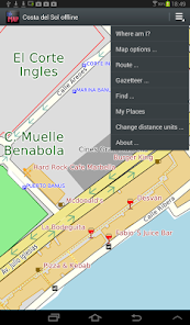
Terrain is shown on the map, and can be turned on or off.
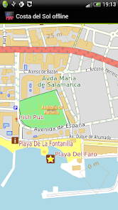
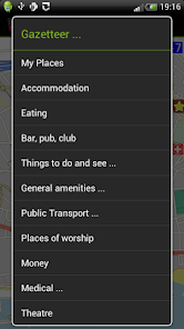
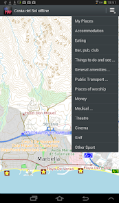
The app includes a search function and a gazetteer of commonly needed items like hotels, eating places, post offices and pharmacies as well as museums and other things to see and do.
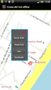
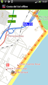
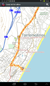
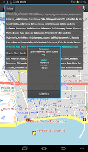
Turn-by-turn navigation is available for car, bicycle or foot. If you don't have a GPS device, you can still show a route between two locations.
Navigation will show you an indicative route. The developers provide it without any guarantee that it is always correct. For example, OpenStreetMap does not always have turn restrictions - places where it is illegal to turn. Some rural roads may be suitable for four-wheel drive vehicles only and/or for people familiar with the area and terrain. Use with care and above all look out for and obey road signs.
We hope it does not happen to you but: Like most small developers, we cannot test a wide variety of phones and tablets. If you have trouble running the application, do email us and we will try to help and/or refund you.
No ads. All features fully functional, no extra downloads, no "in app purchases" required.
The map includes Marbella, Torremolinos, Málaga, Malaga Airport, Torre del Mar, Fuengirola and the entire province if you fancy a day away from the beach. It is based on OpenStreetMap data, http://www.openstreetmap.org.
What is good in Costal del Sol: Roads, tracks, airports, beaches, things to do and see appear well mapped. Coverage of hotels is reasonable.
What is not so good: Detailed point of interest. There is coverage of some tourist eating places and amenities like hospitals, banks along the coast but it is not complete. There are almost no doctors mapped. Some residential and smaller roads lack names. You can help improve it by becoming an OpenStreetMap contributor. We will publish app updates with new information.
Terrain is shown on the map, and can be turned on or off.
The app includes a search function and a gazetteer of commonly needed items like hotels, eating places, post offices and pharmacies as well as museums and other things to see and do.
Turn-by-turn navigation is available for car, bicycle or foot. If you don't have a GPS device, you can still show a route between two locations.
Navigation will show you an indicative route. The developers provide it without any guarantee that it is always correct. For example, OpenStreetMap does not always have turn restrictions - places where it is illegal to turn. Some rural roads may be suitable for four-wheel drive vehicles only and/or for people familiar with the area and terrain. Use with care and above all look out for and obey road signs.
We hope it does not happen to you but: Like most small developers, we cannot test a wide variety of phones and tablets. If you have trouble running the application, do email us and we will try to help and/or refund you.
Updated on
Safety starts with understanding how developers collect and share your data. Data privacy and security practices may vary based on your use, region and age The developer provided this information and may update it over time.

No data shared with third parties
Learn more about how developers declare sharing

This app may collect these data types
App activity, App info and performance and Device or other IDs

Data is encrypted in transit

Data can’t be deleted
What's new
- Latest OpenStreetMap data
- Android 10 compatibility
- Removed "Advanced Find" menu item to simplify the app, contact us via our Developer Email on the Google Play Store if you want this back.
- Added Crashlytics. If the app crashes, information about the crash is automatically sent to us. No personal data is sent. Your location is not sent.
- Ski runs and ski lifts now show where applicable
- Reservoir dams now show
- Some map style tweaks, e.g service roads thinner to contrast them better.


