Retrace
4.9star
53 reviews
500+
Downloads

Everyone
info

About this app
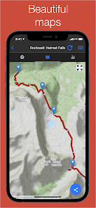
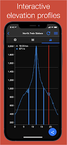
Replace your old hand-held hiking / running / biking GPS with Retrace. Retrace makes it simple to record a GPS log of your activities. Simple displays highlight distance, speed, and elevation changes. If you have data, the map tab shows you where you are on the map; if you do not have data (or have it disabled to save battery), a grid-based view is presented. Elevation profiles are also shown and any waypoints along your track will be added to the elevation profile so you can better understand where they happened.
Many more details can be found on the App Site: http://retrace.mobi
Retrace caches the most recent 500 map tiles for offline use, so you can pan the map around the area you will be going in advance of your trip and not require any data while you are on your activity.
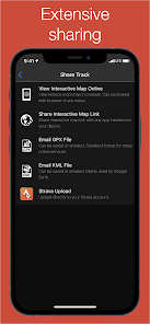
Extensive sharing functionality is built into Retrace. With our free online portal you can easily share your track with Facebook, Twitter, Whatsapp or any other social network. An example of a shared track can be viewed here:
https://retrace.mobi/v/j955d793
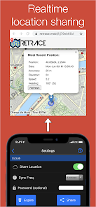
Additionally, Retrace offers optional anonymous online tracking if you wish to upload your current position automatically every few minutes for your loved ones or friends to track your progress. No username is required and you can optionally password-protect your location. An example of the tracking page can be found here:
https://retrace.mobi/l/j79eb65d
If you ever have any problems, questions, or suggestions the options page has a 'send feedback' button. If you contact us, we will try to sort out any problems ASAP! You can also email us directly at ulti.org@gmail.com
Retrace is great for:
✓ biking
✓ running
✓ hiking
✓ walking
✓ downhill/x-country skiing
✓ off roading (ATV, motorcycle, etc.)
✓ tracking flights / road trips
✓ horseback riding
✓ canoeing / kayaking
✓ golfing
✓ rock climbing / mountaineering
✓ nordic walking
✓ stroller walking / stroller running
✓ any other activity you want to record
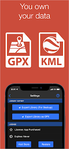
Retrace supports a variety of export options:
✓ Strava
✓ GPX: Used online e.g., RunTracker/Endomondo
✓ KML: Used by services like Google Earth
Tracks can also be _imported_ into Retrace using the popular GPX format so that you can follow them on your activities (e.g., you can export a Strava route and import it into Retrace). Your full track library can also be easily exported so it can be migrated to a new device.
Retrace also makes it easy to tag you activities so it is easy to go back and look at tracks for past activities. The track list is capable of displaying thousands of tracks; the track filter lets you quickly find the track you are looking for by filtering on both track names and tags.
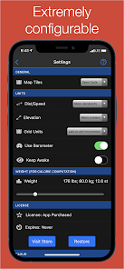
A variety of configuration options are provided to configure Retrace exactly for you! Locations can be given in Lat/Lon, UTM, MGRS, or UK Grid Ref. Distance can be displayed in km, mi, or nm. Speed can be in km/h, mi/h or knots.
Retrace permissions only require the ability to track your location and save your tracks; the network permissions are optional and are only used if you want to export your tracks to another service.
Strava note: If you tag your track as 'commute' it will be uploaded as a commute. Tracks will be uploaded with the default privacy settings you have set for your Strava account.
Many more details can be found on the App Site: http://retrace.mobi
Retrace caches the most recent 500 map tiles for offline use, so you can pan the map around the area you will be going in advance of your trip and not require any data while you are on your activity.
Extensive sharing functionality is built into Retrace. With our free online portal you can easily share your track with Facebook, Twitter, Whatsapp or any other social network. An example of a shared track can be viewed here:
https://retrace.mobi/v/j955d793
Additionally, Retrace offers optional anonymous online tracking if you wish to upload your current position automatically every few minutes for your loved ones or friends to track your progress. No username is required and you can optionally password-protect your location. An example of the tracking page can be found here:
https://retrace.mobi/l/j79eb65d
If you ever have any problems, questions, or suggestions the options page has a 'send feedback' button. If you contact us, we will try to sort out any problems ASAP! You can also email us directly at ulti.org@gmail.com
Retrace is great for:
✓ biking
✓ running
✓ hiking
✓ walking
✓ downhill/x-country skiing
✓ off roading (ATV, motorcycle, etc.)
✓ tracking flights / road trips
✓ horseback riding
✓ canoeing / kayaking
✓ golfing
✓ rock climbing / mountaineering
✓ nordic walking
✓ stroller walking / stroller running
✓ any other activity you want to record
Retrace supports a variety of export options:
✓ Strava
✓ GPX: Used online e.g., RunTracker/Endomondo
✓ KML: Used by services like Google Earth
Tracks can also be _imported_ into Retrace using the popular GPX format so that you can follow them on your activities (e.g., you can export a Strava route and import it into Retrace). Your full track library can also be easily exported so it can be migrated to a new device.
Retrace also makes it easy to tag you activities so it is easy to go back and look at tracks for past activities. The track list is capable of displaying thousands of tracks; the track filter lets you quickly find the track you are looking for by filtering on both track names and tags.
A variety of configuration options are provided to configure Retrace exactly for you! Locations can be given in Lat/Lon, UTM, MGRS, or UK Grid Ref. Distance can be displayed in km, mi, or nm. Speed can be in km/h, mi/h or knots.
Retrace permissions only require the ability to track your location and save your tracks; the network permissions are optional and are only used if you want to export your tracks to another service.
Strava note: If you tag your track as 'commute' it will be uploaded as a commute. Tracks will be uploaded with the default privacy settings you have set for your Strava account.
Updated on
Safety starts with understanding how developers collect and share your data. Data privacy and security practices may vary based on your use, region and age The developer provided this information and may update it over time.

No data shared with third parties
Learn more about how developers declare sharing

No data collected
Learn more about how developers declare collection
Ratings and reviews
4.9
51 reviews

Hamilton Stewart
- Flag inappropriate
11 November 2021
This is my favorite app. Unlike map GPS that try to always force mapping onto a road this maps your true path, even across a open field or water. It will capture a track even if there is no Internet, it will show it on a map when Internet becomes available. Great for hiking, air travel, or a parking lot. Minus a star for stopping tracks if you switch apps without pausing first.
2 people found this review helpful

Lawre Pietras
- Flag inappropriate
23 April 2022
Great features and fabulous support! Like many others I have been using this app since my BlackBerry days. I use it for tracking all types of activities on land and water, in all seasons. The route shown on the map is very accurate along with the data captured. On the very rare occasion that I have found a software problem, I have emailed the developer. I received developer feedback quickly and a software update within a very reasonable time frame. Thank you very much for a great app and support
1 person found this review helpful

M Smith
- Flag inappropriate
- Show review history
31 March 2024
Used Retrace for years, worked fine. Now essentially useless. It misses multiple points and the data is 90% incomplete. Will try reinstalling one more time. If non-functional still, G'BYE! Update: G'BYE!
What's new
★ Android 12 support.
★ Complete revamp of moving calcuations to better reflect your activities.
★ Improved location upload with poor data reception.
✓ Better stationary detection.
✓ Map now shows tracking is paused with grey position marker.
✓ Update track view page with descriptions and tag decorations.
✓ Improved map view when GPS signal is weak.
✓ Better handling of new Strava duplicate activity detection.
✓ Added ability to mute Strava activities with 'mute' tag.
* Increase GPS sensitivity.