
LiPAD TOPOS Mobile Mapping
100+
Downloads

Everyone
info

About this app
Li.PAD MOBILE MAPPING - THE APP FOR THE SURVEY GPS
Li.PAD Mobile Mapping stems from the companies in the energy sector to equip itself with a user friendly tool for surveying in the field of light points, Switchboards and network elements for the purpose of drawing up the state of the system Made Public Lighting , or as a certain and precise starting point for the production of PRIC (Municipal Lighting Plan).
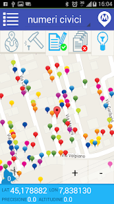
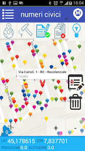
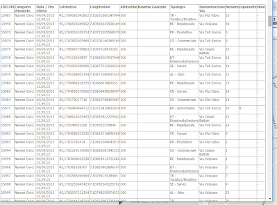
Li.PAD TOPOS Mobile Mapping - Place names - house numbering
through the detection of house numbers the City collects information on house numbering and on buildings located in their territory.
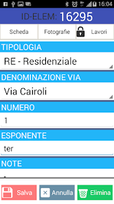
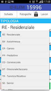
The procedure allows the import of the official driving (list tract) and catalog access into the following categories: RE - Residential, BX - Garage, CR - Wheeler, PR - Production, CO - Commercial, DT - Directional / tertiary, TR - Tourism / Receptive, SE - Services, AL - Other.
Easy to use
The use of a device such as smartphone makes it extremely easy and intuitive mapping work, even by bicycle.
Lower hardware costs
The combined smartphone and GPS receiver self (optional), limited to a few tens of euro the preparation of the working equipment.
grade features
The development of the procedure closely with companies in the energy sector allows the timely scheduling of technical features.
DXF export, XLS, ...
Twenty-five years of cartographic application development allow us to communicate with popular GIS and technical software such as AutoCAD and ArcGIS.
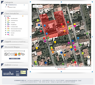
- FUNCTIONALITY' -
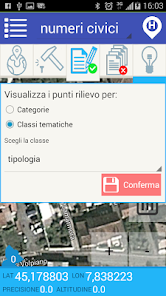
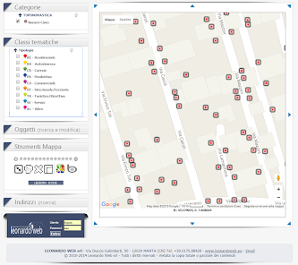
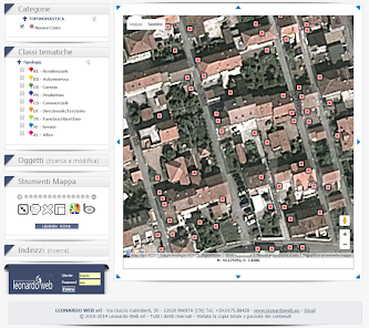
CATEGORY
Allows the selection of the class of elements to be mapped (house numbers, driveways, ...)
TYPE MAP
It allows choosing the type of map to represent (road, satellite, mixed).
AREA MAP
It shows the portion of the territory being mapped with highlighted or not the objects have already been recognized; if necessary, can be replaced by the Compile tab, the maintenance carried out or the attached images.
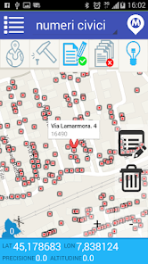
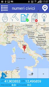
COORDINATES
It presents the current position values: latitude, longitude, altitude and accuracy of the detected position.
GPS
Activate the external GPS receiver (or internal radio to the device) and the subsequent interactive activities on the area map.
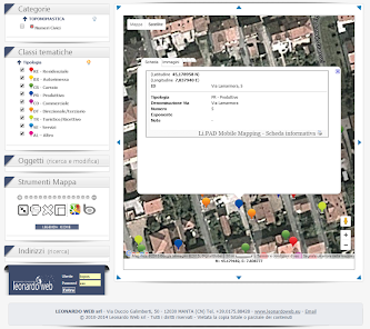
SURVEY
The pressure analyzes the GPS position of the current point and fix its position on the map.
SHEET
Active or not the opening and subsequent compilation of the information document asssociata the point detected earlier.
COPY
Active or not the serial nature of the information associated with points measured in consecutio and with same characteristics.
ACCENDI
Shows or hides the point features found in the current map extent.
- SPIN OFF -
The high degree of personalization of the service made it possible to prepare various solutions for surveying in the field or as a fixed station and the subsequent management of information in personal sites.
Li.PAD Energy - Lighting - lights and electrical panels
Li.PAD Commerce - Productive Activities and / or Services Public
Li.PAD Covert - Technological networks, wells and network elements
Li.PAD Signage - Road signs and / or posters
Li.PAD Green - Green public, monitoring vegetative state
Li.PAD Rainbow - Public Roads, landslides and storm damage
Li.PAD Garbage - Collection S.U.W. - Bins and ecological islands.
Li.PAD Mobile Mapping stems from the companies in the energy sector to equip itself with a user friendly tool for surveying in the field of light points, Switchboards and network elements for the purpose of drawing up the state of the system Made Public Lighting , or as a certain and precise starting point for the production of PRIC (Municipal Lighting Plan).
Li.PAD TOPOS Mobile Mapping - Place names - house numbering
through the detection of house numbers the City collects information on house numbering and on buildings located in their territory.
The procedure allows the import of the official driving (list tract) and catalog access into the following categories: RE - Residential, BX - Garage, CR - Wheeler, PR - Production, CO - Commercial, DT - Directional / tertiary, TR - Tourism / Receptive, SE - Services, AL - Other.
Easy to use
The use of a device such as smartphone makes it extremely easy and intuitive mapping work, even by bicycle.
Lower hardware costs
The combined smartphone and GPS receiver self (optional), limited to a few tens of euro the preparation of the working equipment.
grade features
The development of the procedure closely with companies in the energy sector allows the timely scheduling of technical features.
DXF export, XLS, ...
Twenty-five years of cartographic application development allow us to communicate with popular GIS and technical software such as AutoCAD and ArcGIS.
- FUNCTIONALITY' -
CATEGORY
Allows the selection of the class of elements to be mapped (house numbers, driveways, ...)
TYPE MAP
It allows choosing the type of map to represent (road, satellite, mixed).
AREA MAP
It shows the portion of the territory being mapped with highlighted or not the objects have already been recognized; if necessary, can be replaced by the Compile tab, the maintenance carried out or the attached images.
COORDINATES
It presents the current position values: latitude, longitude, altitude and accuracy of the detected position.
GPS
Activate the external GPS receiver (or internal radio to the device) and the subsequent interactive activities on the area map.
SURVEY
The pressure analyzes the GPS position of the current point and fix its position on the map.
SHEET
Active or not the opening and subsequent compilation of the information document asssociata the point detected earlier.
COPY
Active or not the serial nature of the information associated with points measured in consecutio and with same characteristics.
ACCENDI
Shows or hides the point features found in the current map extent.
- SPIN OFF -
The high degree of personalization of the service made it possible to prepare various solutions for surveying in the field or as a fixed station and the subsequent management of information in personal sites.
Li.PAD Energy - Lighting - lights and electrical panels
Li.PAD Commerce - Productive Activities and / or Services Public
Li.PAD Covert - Technological networks, wells and network elements
Li.PAD Signage - Road signs and / or posters
Li.PAD Green - Green public, monitoring vegetative state
Li.PAD Rainbow - Public Roads, landslides and storm damage
Li.PAD Garbage - Collection S.U.W. - Bins and ecological islands.
Updated on
Safety starts with understanding how developers collect and share your data. Data privacy and security practices may vary based on your use, region and age The developer provided this information and may update it over time.

No data shared with third parties
Learn more about how developers declare sharing

This app may collect these data types
Location, Photos and videos and Device or other IDs

Data isn’t encrypted
Data can’t be deleted
What's new
-Correzioni problemi gps mork


