

Marine Weather Pro| SailGrib

4.8star
840 reviews
10K+
Downloads

Everyone
info


About this app
YACHTING WORLD - "IMPRESSIVE" - July 2014
Designed for Iridium GO! and Approved by Iridium.
SaiGrib is a weather and tides forecast app designed for the sailing community, cruisers and raceers, worlwide.
Get all the major models of weather forecast from many different sources in one easy to use app.
Weather data are downloaded as grib files while tides are calculated locally on your device.
Features
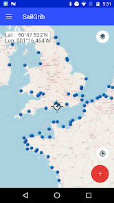
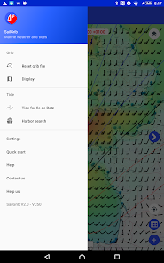
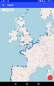
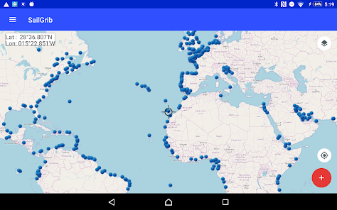
- pan and zoom the map to choose your region
- download data using the best Grib files providers : SailGrib, Great Circle, GMN, OpenWRF, SailDocs...
- specify the parameters(wind, pressure...) to your needs
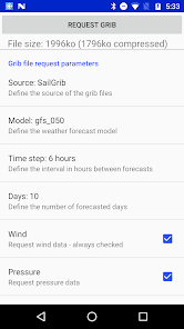
- request can be adjusted to match a maximum file size
- can be used at sea with a satellite phone or the Iridium Go
- offlline maps capability combined with satellite mail allows usage at sea.
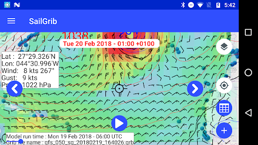
With SailGrib, you can download and view the following data:
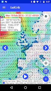
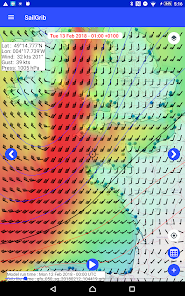
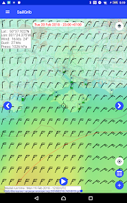
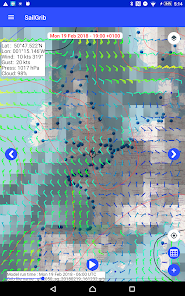
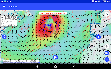
- Wind (10m above sea level)
- Pressure (reduced to mean sea level)
- Precipitation (accumulated over 6 hours)
- Total cloud cover
- Air Temperature ( 2m above ground)
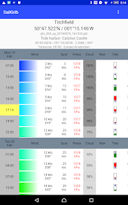
- Wave (significant wave height, mean wave direction and period)
- CAPE
- Tidal or oceanic currents
With SailGrib, you can specify the following parameters for your grib file request:
- grib provider : SailGrib, Great Circle, SailDocs, Open WRF, MeteoConsult, GMN, Mercator Ocean for oceanic and coastal currents ....
- request method : direct download (SailGrib, Great Circle, MeteoConsult, GMN) or email (SailDocs, GMN or Great Circle)
- grid resolution: from very high resolution to 2.5°
- time step between forecasts :from 1 hour to 12 hours depending on models
- number of days for the forecast: from 1 to 14 depending on model
- maximum file size. SailGrib estimates the size of the grib file you request and adjust the grid resolution and the time step to make sure your file will size be lower than your set limit.
With SailGrib, you can view the following data:
- Windbarbs
- Isobars
- Precipitation maps
- Cloud cover maps
- Temperature maps
- Waves maps and arrows
- CAPE map
- Currents
WARNINGS:
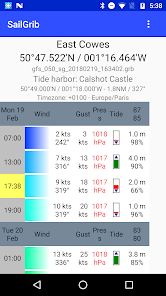
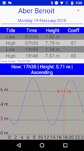
- Tide forecast are not official and are for reference purpose only.
- Grib files are computer-generated forecast files which are sent without review, and are offered on an as-is basis. There is no assurance that the data is accurate or correct. By using these data you agree to these limitations and assume all the responsibility for their use.
DISCLOSURE:
SailGrib uses the JGRIB Java GRIB decoder (jgrib.sourceforge.net) and OpenStreetMap (www.openstreetmap.org)
Designed for Iridium GO! and Approved by Iridium.
SaiGrib is a weather and tides forecast app designed for the sailing community, cruisers and raceers, worlwide.
Get all the major models of weather forecast from many different sources in one easy to use app.
Weather data are downloaded as grib files while tides are calculated locally on your device.
Features
- pan and zoom the map to choose your region
- download data using the best Grib files providers : SailGrib, Great Circle, GMN, OpenWRF, SailDocs...
- specify the parameters(wind, pressure...) to your needs
- request can be adjusted to match a maximum file size
- can be used at sea with a satellite phone or the Iridium Go
- offlline maps capability combined with satellite mail allows usage at sea.
With SailGrib, you can download and view the following data:
- Wind (10m above sea level)
- Pressure (reduced to mean sea level)
- Precipitation (accumulated over 6 hours)
- Total cloud cover
- Air Temperature ( 2m above ground)
- Wave (significant wave height, mean wave direction and period)
- CAPE
- Tidal or oceanic currents
With SailGrib, you can specify the following parameters for your grib file request:
- grib provider : SailGrib, Great Circle, SailDocs, Open WRF, MeteoConsult, GMN, Mercator Ocean for oceanic and coastal currents ....
- request method : direct download (SailGrib, Great Circle, MeteoConsult, GMN) or email (SailDocs, GMN or Great Circle)
- grid resolution: from very high resolution to 2.5°
- time step between forecasts :from 1 hour to 12 hours depending on models
- number of days for the forecast: from 1 to 14 depending on model
- maximum file size. SailGrib estimates the size of the grib file you request and adjust the grid resolution and the time step to make sure your file will size be lower than your set limit.
With SailGrib, you can view the following data:
- Windbarbs
- Isobars
- Precipitation maps
- Cloud cover maps
- Temperature maps
- Waves maps and arrows
- CAPE map
- Currents
WARNINGS:
- Tide forecast are not official and are for reference purpose only.
- Grib files are computer-generated forecast files which are sent without review, and are offered on an as-is basis. There is no assurance that the data is accurate or correct. By using these data you agree to these limitations and assume all the responsibility for their use.
DISCLOSURE:
SailGrib uses the JGRIB Java GRIB decoder (jgrib.sourceforge.net) and OpenStreetMap (www.openstreetmap.org)
Updated on
Safety starts with understanding how developers collect and share your data. Data privacy and security practices may vary based on your use, region and age The developer provided this information and may update it over time.


Ratings and reviews
4.9
620 reviews

Wayne Tyrril
- Flag inappropriate
18 February 2022
Great app to help comprehend the grib files. But this app could be improved with a simple manual input of a position, course and speed. I can then view the expected wx as the estimated position progresses along this course every 3 hours. I use a win gribview program that does this. A vast improvement over the competition if this feature could be added for android. You directed me to Sailgrib WR, no that won't do it. This request is for a SailGrib viewer enhancement. Can it be done for android?
1 person found this review helpful

Terence Bailey
- Flag inappropriate
6 December 2023
Use it every day, excellent except since last update it won't open if set to Satellite map you have to leave it in default map then change manually.
SailGrib
26 November 2019
Thanks, no change for the rain. It is only available in the GFS model.

A Google user
- Flag inappropriate
1 June 2019
Great lakes weather forecast not good at this time of year use less to me waste of $$ app also crashes trying to load saildocs grib files.IT also seems to be way behind the latest updates then some other apps that offer grib files (pocket grib and weather4d ) app also seems to be searching for gps signal constantly draining the battery
5 people found this review helpful
SailGrib
13 February 2016
Sorry if you are having issues. The Great Lakes forecast is from the NOAA GFS model. The grib request through SailDocs is used by thousands of users with no known issue. No, the app is not constantly searching for GPS, it is getting the position of the device only once to center the map. What do you mean that SailGrib s behind? I think it is ahead!
What's new
- Fixed a bug that prevented access to saved grib files


