
Johannesweg - Wandern mit Sinn
10K+
Downloads

Everyone
info


About this app
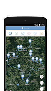
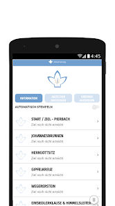
The "Johannesweg App" is a helpful hiking companion that helps pilgrims to determine their current location and shows them the route of the path on the hiking map. In addition to the twelve stamp stations, places to stop and sleep are also shown on the map. In addition to the card, the passport with the digital stamp function is also integrated. After stamping eight of the twelve stations, the hiker can pick up the St. John's Way needle from an inn along the way.
The Johannesweg leads in the shape of a lily through the wonderful hilly landscape of the Mühlviertler Alm region. With its 84 kilometers, it can be hiked in three or four daily stages. The twelve stations along the way are intended to take people out of everyday life, give them the courage to look ahead and reflect on themselves again. Make yourself on the way to St. John.
The app offers the following functions:
- Trail marked on the hiking map with stations, places to stop and sleep
- Position determination via GPS
- Integrated stamp pass to digitally stamp and request a certificate
- Elevation profile
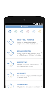
- Information on stations, places to eat, sleep and taxis
The Johannesweg leads in the shape of a lily through the wonderful hilly landscape of the Mühlviertler Alm region. With its 84 kilometers, it can be hiked in three or four daily stages. The twelve stations along the way are intended to take people out of everyday life, give them the courage to look ahead and reflect on themselves again. Make yourself on the way to St. John.
The app offers the following functions:
- Trail marked on the hiking map with stations, places to stop and sleep
- Position determination via GPS
- Integrated stamp pass to digitally stamp and request a certificate
- Elevation profile
- Information on stations, places to eat, sleep and taxis
Updated on
Safety starts with understanding how developers collect and share your data. Data privacy and security practices may vary based on your use, region, and age. The developer provided this information and may update it over time.

No data shared with third parties
Learn more about how developers declare sharing

No data collected
Learn more about how developers declare collection
What's new
BugFix KM Anzeige
div. Verbesserungen der App
div. Verbesserungen der App