
MNsight - Lidar and what's bel
4,9star
28 avis
5K+
Téléchargements

Tout public
info

À propos de l'application
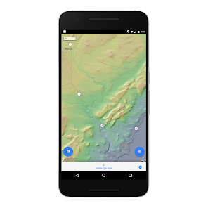
Explore the beautiful detail of Minnesota's statewide Lidar topographic dataset, and find out what lies beneath your feet - anywhere in the state.
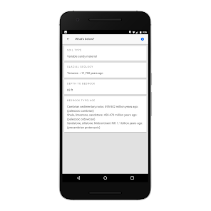
Tap anywhere on the map within Minnesota to get information about the soil, glacial geology, depth of the bedrock below the land's surface, and the types and ages of the bedrock in that location. Press the 'below me now' button to instantly get the above information about your current GPS determined location.
Tap anywhere on the map within Minnesota to get information about the soil, glacial geology, depth of the bedrock below the land's surface, and the types and ages of the bedrock in that location. Press the 'below me now' button to instantly get the above information about your current GPS determined location.
Date de mise à jour
Sécurité des données
Le développeur peut indiquer ici comment son appli recueille et utilise vos données. En savoir plus sur la sécurité des données

Aucune information disponible
Notes et avis
4,8
27 avis
Nouveautés
Geology queries fixed!


