Compass Eye Bearing Compass
100+
Téléchargements

Tout public
info


À propos de l'application
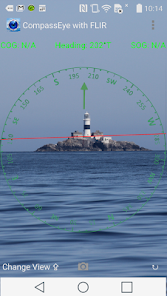
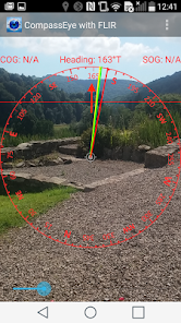
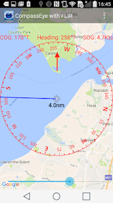
A Professional Bearing Compass with Augmented Reality and upto 8x zoom designed to help navigate on land, sea and air and used much like a pair of Compass Binoculars. When held vertically it shows the real-time camera view with a compass, bearings and artificial horizon overlaid, when flat it shows a real time map centred on where you are with the bearings and compass overlaid. For use at sea on land and in the air.
Three settable bearings available (red, green and yellow) and a course over ground bearing (blue). Displays your speed and course over ground too.
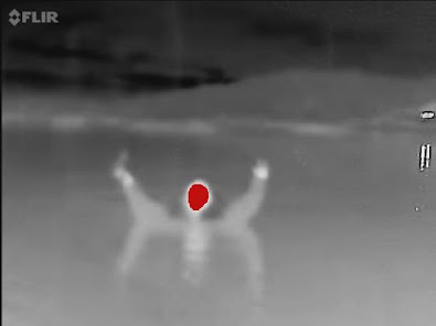
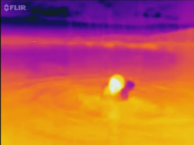
CompassEye also works with the amazing FLIR ONE Thermal Imager for Android allowing you to spot ships and people at night and in fog too.
MAIN FEATURES
- Compass overlaid on live camera view
- 8x Digital zoom
- Back, transit, or collision bearing markers
- Draggable Green and red bearing lines
- Triangulation bearings
- Magnetic or True North setting with variation based on location
- Live map view with position and track
- Artificial Horizon
- Night Vision with FLIROne® Infra-red support
HOW TO USE
Taking a bearing - look through your device at the distant object, line it up with the centre line and read off the bearing! Zoom in to get more accuracy.
Setting a bearing - look through your iPhone at the point you want to get to, tap the Bearing button (Top right) and follow the yellow bearing line.
Setting a bearing from the map - lay the iPhone flat, rotate or drag a bearing line to line up with the point you are aiming for and follow that bearing.
Triangulation - use the three bearing lines - yellow green and red to take bearings on 3 points. Capture the view including compass, bearings, time and location information and then use the photo to plot a fix on a chart.
Clearance bearings to a point on an approach - set one line to the minimum bearing (e.g. the angle the target must bear greater than) and the other line to the maximum bearing and navigate between the two. Use the colours according to the IALA lateral markings to help you remember which way to steer. e.g. in North America use red for the minimum bearing and green for the maximum (vice-versa in Europe!).
NAVIGATION SAFETY
Compass Eye should only be used for basic navigation assistance. Never rely solely on the digital compass for determining direction, proximity or distance. The user is responsible for the prudent use of information provided by this application and must not use it for direct navigation.
Three settable bearings available (red, green and yellow) and a course over ground bearing (blue). Displays your speed and course over ground too.
CompassEye also works with the amazing FLIR ONE Thermal Imager for Android allowing you to spot ships and people at night and in fog too.
MAIN FEATURES
- Compass overlaid on live camera view
- 8x Digital zoom
- Back, transit, or collision bearing markers
- Draggable Green and red bearing lines
- Triangulation bearings
- Magnetic or True North setting with variation based on location
- Live map view with position and track
- Artificial Horizon
- Night Vision with FLIROne® Infra-red support
HOW TO USE
Taking a bearing - look through your device at the distant object, line it up with the centre line and read off the bearing! Zoom in to get more accuracy.
Setting a bearing - look through your iPhone at the point you want to get to, tap the Bearing button (Top right) and follow the yellow bearing line.
Setting a bearing from the map - lay the iPhone flat, rotate or drag a bearing line to line up with the point you are aiming for and follow that bearing.
Triangulation - use the three bearing lines - yellow green and red to take bearings on 3 points. Capture the view including compass, bearings, time and location information and then use the photo to plot a fix on a chart.
Clearance bearings to a point on an approach - set one line to the minimum bearing (e.g. the angle the target must bear greater than) and the other line to the maximum bearing and navigate between the two. Use the colours according to the IALA lateral markings to help you remember which way to steer. e.g. in North America use red for the minimum bearing and green for the maximum (vice-versa in Europe!).
NAVIGATION SAFETY
Compass Eye should only be used for basic navigation assistance. Never rely solely on the digital compass for determining direction, proximity or distance. The user is responsible for the prudent use of information provided by this application and must not use it for direct navigation.
Date de mise à jour
La sécurité, c'est d'abord comprendre comment les développeurs collectent et partagent vos données. Les pratiques concernant leur confidentialité et leur protection peuvent varier selon votre utilisation, votre région et votre âge. Le développeur a fourni ces informations et peut les modifier ultérieurement.

Aucune donnée partagée avec des tiers
En savoir plus sur la manière dont les développeurs déclarent le partage

Aucune donnée collectée
En savoir plus sur la manière dont les développeurs déclarent la collecte
Nouveautés
Upgraded to work with latest google versions


