
Boat Beacon - AIS Navigation
In-app purchases
3.3star
349 reviews
10K+
Downloads

Everyone
info




About this app
AIS receiver and display using just your Android device.
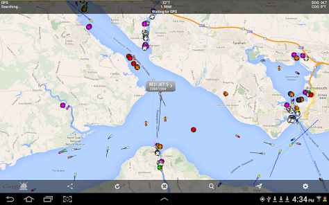
Boat Beacon is the only Marine AIS ship tracking app to provide Collision Detection, use real-time data and share your own boat’s position with other internet AIS users.
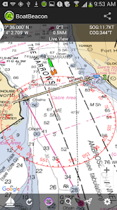
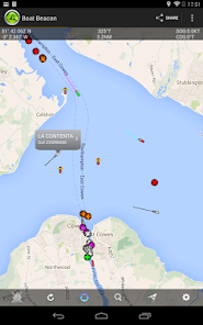
Specifically designed for use on the water, as well as showing all the Ships around you on a chart, Boat Beacon uniquely provides Bearing, Range and Closest Point of Approach (CPA) calculations in addition to AIS ship information. Transmits as well as receives internet AIS and is the only app that continuously monitors CPA, notifying if potential collisions are detected even when the app is in the background.
Key Features
------------
Receives and sends AIS ship data in real-time via the internet. No VHF AIS receiver, transponder or aerial required.
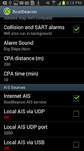
Over the horizon Collision and SART detection (30 miles radius) using continuous Closest Point of Approach (CPA) calculations - highlights boats that are on a potential collision course and alarms even when the app is in the background.
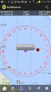
Provides Bearing and Distance information to other boats in addition to AIS information like speed, course, location, name, length etc. Shows you a track of the boats most recent voyage.
Share your live position, speed course and destination. People can follow you using Boat Beacon or our free Boat Watch app and on leading internet AIS systems like MarineTraffic and Ship Finder. Transmit also works continuously in the background when enabled.
Live Map view with compass overlay which rotates with you so you can look in the direction of the ships on the map to locate them. You can also tilt the map to get a 3D perspective by dragging upwards with two fingers.
NOAA US and UKHO Marine Charts (IAP required)
Extensive details on other ships including Photos.
Search for boats or places by name or MMSI.
Share your track and position with friends and family instantly and in real time via email, Twitter and Facebook etc.
AIS Share lets you share BoatBeacon's live AIS data with other apps like Navionics on your device. (IAP required with free 3 day trial)
Man Overboard (MOB) & Anchor Watch:-
-MOB tracks the position, distance, bearing & time in water.
-Anchor Watch marks your anchor's position & alerts if you drift out of range or too fast (IAP with free 3 day trial).
Arm all the crews in a race with Boat Beacon and see real time updates on the race positions. Watch the action and replay it back in the Club-house with Boat Beacon's dedicated live race web pages.
VHF AIS with RTL-SDR and AIS Share app.
Local NMEA AIS via Wifi and USB.
Boat Beacon requires internet access to work. Most popular coastal areas around the world including the US and UK have mobile data access (2G or better) extending 12 or more miles out to sea.
Requirements:
Android Smartphone or Tablet with GPS.
Internet connection.
You do not need an MMSI to use Boat Beacon and you can be seen on Boat Beacon by other Boat Beacon users without having one. However if you want to be seen on Global AIS systems like Marine Traffic, Ship Finder and AIS Hub, etc. then you will need to have and use an MMSI number. If you don't have an MMSI for your boat you can obtain one in the US by visiting http://www.boatus.com/mmsi (the USCG approved agent). Alternatively email us for a free internet MMSI number.
Please note that continued use of GPS running in the background can dramatically decrease battery life.
AIS Ship data is provided by a network of voluntary AIS shore based stations. Some areas may not have AIS coverage.
N.B. This is not an AIS transponder. You will not be visible to other ships on their AIS systems unless they also use data from the same land based AIS networks.
NOT FOR NAVIGATION
This program is distributed in the hope that it will be useful. Boat Beacon should only be used for basic navigation reference and should not be solely relied upon to determine precise locations, proximity, distance, or direction.
Boat Beacon is the only Marine AIS ship tracking app to provide Collision Detection, use real-time data and share your own boat’s position with other internet AIS users.
Specifically designed for use on the water, as well as showing all the Ships around you on a chart, Boat Beacon uniquely provides Bearing, Range and Closest Point of Approach (CPA) calculations in addition to AIS ship information. Transmits as well as receives internet AIS and is the only app that continuously monitors CPA, notifying if potential collisions are detected even when the app is in the background.
Key Features
------------
Receives and sends AIS ship data in real-time via the internet. No VHF AIS receiver, transponder or aerial required.
Over the horizon Collision and SART detection (30 miles radius) using continuous Closest Point of Approach (CPA) calculations - highlights boats that are on a potential collision course and alarms even when the app is in the background.
Provides Bearing and Distance information to other boats in addition to AIS information like speed, course, location, name, length etc. Shows you a track of the boats most recent voyage.
Share your live position, speed course and destination. People can follow you using Boat Beacon or our free Boat Watch app and on leading internet AIS systems like MarineTraffic and Ship Finder. Transmit also works continuously in the background when enabled.
Live Map view with compass overlay which rotates with you so you can look in the direction of the ships on the map to locate them. You can also tilt the map to get a 3D perspective by dragging upwards with two fingers.
NOAA US and UKHO Marine Charts (IAP required)
Extensive details on other ships including Photos.
Search for boats or places by name or MMSI.
Share your track and position with friends and family instantly and in real time via email, Twitter and Facebook etc.
AIS Share lets you share BoatBeacon's live AIS data with other apps like Navionics on your device. (IAP required with free 3 day trial)
Man Overboard (MOB) & Anchor Watch:-
-MOB tracks the position, distance, bearing & time in water.
-Anchor Watch marks your anchor's position & alerts if you drift out of range or too fast (IAP with free 3 day trial).
Arm all the crews in a race with Boat Beacon and see real time updates on the race positions. Watch the action and replay it back in the Club-house with Boat Beacon's dedicated live race web pages.
VHF AIS with RTL-SDR and AIS Share app.
Local NMEA AIS via Wifi and USB.
Boat Beacon requires internet access to work. Most popular coastal areas around the world including the US and UK have mobile data access (2G or better) extending 12 or more miles out to sea.
Requirements:
Android Smartphone or Tablet with GPS.
Internet connection.
You do not need an MMSI to use Boat Beacon and you can be seen on Boat Beacon by other Boat Beacon users without having one. However if you want to be seen on Global AIS systems like Marine Traffic, Ship Finder and AIS Hub, etc. then you will need to have and use an MMSI number. If you don't have an MMSI for your boat you can obtain one in the US by visiting http://www.boatus.com/mmsi (the USCG approved agent). Alternatively email us for a free internet MMSI number.
Please note that continued use of GPS running in the background can dramatically decrease battery life.
AIS Ship data is provided by a network of voluntary AIS shore based stations. Some areas may not have AIS coverage.
N.B. This is not an AIS transponder. You will not be visible to other ships on their AIS systems unless they also use data from the same land based AIS networks.
NOT FOR NAVIGATION
This program is distributed in the hope that it will be useful. Boat Beacon should only be used for basic navigation reference and should not be solely relied upon to determine precise locations, proximity, distance, or direction.
Updated on
Safety starts with understanding how developers collect and share your data. Data privacy and security practices may vary based on your use, region, and age. The developer provided this information and may update it over time.

This app may share these data types with third parties
Location

No data collected
Learn more about how developers declare collection

Data is encrypted in transit

Data can’t be deleted
Ratings and reviews
3.2
291 reviews

Radio Rental
- Flag inappropriate
March 14, 2023
Ive used this app since i started sharing to Steve's site . The app is my daily driver and have my ais-catcher decoder linked to it as well through various receivers .The app is decent for its simplicity and the ability to share from/to multiple devices is excellent. Also the maps and ship icons are laid out clearly and you can differentiate between them . I see some negative reviews with regards to navigation remember these apps are more hobbyist than accuracy. Keep up the good work . Rab
9 people found this review helpful

Randy Ellison
- Flag inappropriate
May 18, 2023
App is cool, functionally of it sucks, many areas you can be right next to a ship or vessel you know has ais and it literally doesn't even show up on the map. You pay money for the app and all the add ons and then later their customer service basically tells you that they don't have coverage in your area. You should probably tell people that before they pay for the app. Don't waste your money on this app... This app is far more novelty than functional.
2 people found this review helpful
Electric Pocket
May 18, 2023
Our coastal real-time AIS coverage is amongst the best in the industry. Your particular case was a river which are notoriously difficult to provide AIS for apart from around major towns/cities or by satellite AIS which is not real-time. Folks can check our coverage for free with our BoatWatch app or via our website.

A Google user
- Flag inappropriate
January 29, 2020
It didn't work on my Lenovo tablet. Keeps saying that GPS is not enabled (it's enabled and all other apps like Google Maps have no issues). "Use GPS satellites" is turned on in Android settings and tablet has GPS built in. Tried to contact support number of times, sent screenshots and descriptions - no response. Wasted $20.
15 people found this review helpful
What’s new
Upate for latest Android OS 16 requirements.
Fix for layouts in boat and trip details, help and faq on OS15 and above
AIS Sharing via NMEA0183 and NMEA2000 to MFDs like the Garmin, Echomap and Simrad/Lowrance/B&G so they can display live AIS targets without needing an AIS VHF receiver and aerial.
Local AIS receive over UDP working again.
Fix for layouts in boat and trip details, help and faq on OS15 and above
AIS Sharing via NMEA0183 and NMEA2000 to MFDs like the Garmin, Echomap and Simrad/Lowrance/B&G so they can display live AIS targets without needing an AIS VHF receiver and aerial.
Local AIS receive over UDP working again.
App support
About the developer
ELECTRIC POCKET LIMITED
business@electricpocket.com
Alpha Lower Leigh Road
PONTYPOOL
NP4 8LG
United Kingdom
+44 7980 725095


