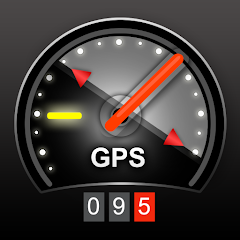
Speedometer 22S GPS Dash Cam
1K+
Téléchargements

Tout public
info

À propos de l'application
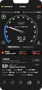
This application is a GPS-based accurate (we create speedometers since 2010) speedometer showing the speed of the device it is installed on. The speed is displayed with a night mode and day mode.
Main features:
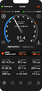
• Measuring travel speed (MPH KM/H)
• Calculate max speed
• Calculate average speed
• Measure the time elapsed
• Measure the distance you have traveled
• Also tells the accuracy of the speedometer
• High and Low speed limit alert system. Add minimum and maximum speed. Set the speed limit and drive calmly
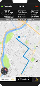
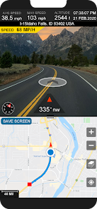
• Street & Map Dual Viewer Speedometer
• Speedometer GPS Live Map Direction. Street View & Speedometer is working with GPS system, gives best route from current location to destination.
• Offline maps, speedometer & live street view in one
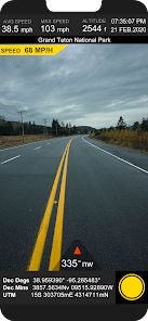
• Earth Street Views Maps & Speedometer app will show panorama view of selected locations on globe. This GPS route finder & navigator live maps app can find multiple ways for traveling. the application will track your GPS coordinates and draw movement trajectory, pointing your current location on standard, satellite or hybrid maps.
• GPS Stamp camera. Helps you to add the speed, address, location coordinates direction, altitude, current date & time.
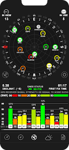
• Gps Test GPS Status Data. It allows you to check GPS signal quality, test GPS module, satellites count, signal quality. Supports GPS, GLONASS, GALILEO, SBAS, BEIDOU and QZSS satellites.
• Tracking. The application will track your GPS coordinates and draw movement trajectory, pointing your current location on standard, satellite or hybrid maps.
- Speed tracking in mph or km/h based on MPH or KM/H mode.
- Distance tracking in miles or kilometers based on MPH or KM/H mode.
- Time tracking.
- Tracking location on map.
- Ability to turn tracking off/on.
- Longitude, latitude coordinates.
• Map integration
- Satellite maps mode.
- Hybrid maps mode.
- Standard maps mode.
- Tracking location changes trajectory.
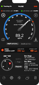
• Compass
- Shows device real-time orientation to magnetic fields.
- Ability to switch between true and magnetic North.
- Location coordinates (longitude, latitude).
- Course
Main features:
• Measuring travel speed (MPH KM/H)
• Calculate max speed
• Calculate average speed
• Measure the time elapsed
• Measure the distance you have traveled
• Also tells the accuracy of the speedometer
• High and Low speed limit alert system. Add minimum and maximum speed. Set the speed limit and drive calmly
• Street & Map Dual Viewer Speedometer
• Speedometer GPS Live Map Direction. Street View & Speedometer is working with GPS system, gives best route from current location to destination.
• Offline maps, speedometer & live street view in one
• Earth Street Views Maps & Speedometer app will show panorama view of selected locations on globe. This GPS route finder & navigator live maps app can find multiple ways for traveling. the application will track your GPS coordinates and draw movement trajectory, pointing your current location on standard, satellite or hybrid maps.
• GPS Stamp camera. Helps you to add the speed, address, location coordinates direction, altitude, current date & time.
• Gps Test GPS Status Data. It allows you to check GPS signal quality, test GPS module, satellites count, signal quality. Supports GPS, GLONASS, GALILEO, SBAS, BEIDOU and QZSS satellites.
• Tracking. The application will track your GPS coordinates and draw movement trajectory, pointing your current location on standard, satellite or hybrid maps.
- Speed tracking in mph or km/h based on MPH or KM/H mode.
- Distance tracking in miles or kilometers based on MPH or KM/H mode.
- Time tracking.
- Tracking location on map.
- Ability to turn tracking off/on.
- Longitude, latitude coordinates.
• Map integration
- Satellite maps mode.
- Hybrid maps mode.
- Standard maps mode.
- Tracking location changes trajectory.
• Compass
- Shows device real-time orientation to magnetic fields.
- Ability to switch between true and magnetic North.
- Location coordinates (longitude, latitude).
- Course
Date de mise à jour
La sécurité, c'est d'abord comprendre comment les développeurs collectent et partagent vos données. Les pratiques concernant leur confidentialité et leur protection peuvent varier selon votre utilisation, votre région et votre âge. Le développeur a fourni ces informations et peut les modifier ultérieurement.


Nouveautés
- Minor optimizations & issue fixes


