
Hawk Map GPS-GIS
ବିଜ୍ଞାପନ ଅନ୍ତର୍ଭୂକ୍ତ
4.5star
1.08ହଟି ସମୀକ୍ଷା
100ହ+
ଡାଉନଲୋଡଗୁଡ଼ିକ

ସମସ୍ତେ
info


ଏହି ଆପ୍ ବିଷୟରେ
GPS and coordinate systems helper especially for military personnel.
It is also a complete helper for airsoft, mountaineering, trekking and hiking, cross running, scouting, hunting, fishing, geocaching, off-road navigation and all other outdoor activities and sports.
With satellite navigation systems such as GPS, GALILEO and GLONASS (GNSS) supported by your device and your sensors, you can see your most accurate position on different map layers.
⭐⭐Features⭐⭐
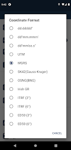
👉 Coordinate Indicator, finder and converter
Format options:
- D°M'S" (WGS84)
- Latitude/Longitude (WGS84)
- UTM (WGS84/NAD83),
- MGRS / U.S. National Grid (USNG) (WGS84/NAD83)
- SK42(Gauss Kruger)
- British National Grid(BNG-OSNG)
- Irish Grid Reference
- ED50 (6°-3°)
- ITRF (6°-3°)
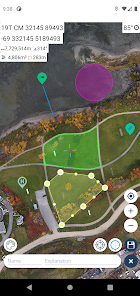
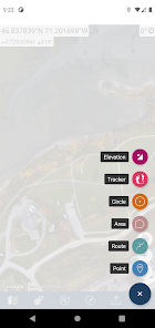
👉 You can make colored markings on the map.
Markers,Polygons,Polylines,Circles
👉 Area & Distance measurement
Distance unit options: m , ft , mi , yd , nmi
Area unit options: m² , ha , ft², yd², mi²
👉 Elevation information
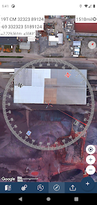
👉 Compass
Angular unit options: Degrees ,NATO mil, Warsaw Mil, Grad
👉 Map style options: (Road,Terrain,Satellite,Night Mode,Hybrid)
👉 KML viewer. (Export and import KML layers).
👉 GPS track recorder.
It is also a complete helper for airsoft, mountaineering, trekking and hiking, cross running, scouting, hunting, fishing, geocaching, off-road navigation and all other outdoor activities and sports.
With satellite navigation systems such as GPS, GALILEO and GLONASS (GNSS) supported by your device and your sensors, you can see your most accurate position on different map layers.
⭐⭐Features⭐⭐
👉 Coordinate Indicator, finder and converter
Format options:
- D°M'S" (WGS84)
- Latitude/Longitude (WGS84)
- UTM (WGS84/NAD83),
- MGRS / U.S. National Grid (USNG) (WGS84/NAD83)
- SK42(Gauss Kruger)
- British National Grid(BNG-OSNG)
- Irish Grid Reference
- ED50 (6°-3°)
- ITRF (6°-3°)
👉 You can make colored markings on the map.
Markers,Polygons,Polylines,Circles
👉 Area & Distance measurement
Distance unit options: m , ft , mi , yd , nmi
Area unit options: m² , ha , ft², yd², mi²
👉 Elevation information
👉 Compass
Angular unit options: Degrees ,NATO mil, Warsaw Mil, Grad
👉 Map style options: (Road,Terrain,Satellite,Night Mode,Hybrid)
👉 KML viewer. (Export and import KML layers).
👉 GPS track recorder.
ଗତ ଅପଡେଟର ସମୟ
ଡେଭେଲପରମାନେ ଆପଣଙ୍କ ଡାଟାକୁ କିପରି ସଂଗ୍ରହ ଏବଂ ସେୟାର କରନ୍ତି ସେହି ଧାରଣା ସହିତ ସୁରକ୍ଷା ଆରମ୍ଭ ହୁଏ। ଆପଣଙ୍କ ବ୍ୟବହାର, ଅଞ୍ଚଳ ଏବଂ ବୟସ ଆଧାରରେ, ଡାଟା ଗୋପନୀୟତା ଓ ସୁରକ୍ଷା କାର୍ଯ୍ୟପଦ୍ଧତିଗୁଡ଼ିକ ଭିନ୍ନ ହୋଇପାରେ। ଡେଭେଲପର ଏହି ସୂଚନା ପ୍ରଦାନ କରିଛନ୍ତି ଏବଂ ସେ ସମୟାନୁସାରେ ଏହାକୁ ଅପଡେଟ କରିପାରନ୍ତି।


ମୂଲ୍ୟାଙ୍କନ ଓ ସମୀକ୍ଷା
4.5
1.06ହଟି ସମୀକ୍ଷା


