

Metar-Taf - Visual decoder

4.9star
947 reviews
10K+
Downloads

Everyone
info


About this app
Visualized METAR and TAF weather information for all airports in the world. Concise summary of everything you need to know about today's aviation weather.
METAR features:
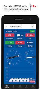
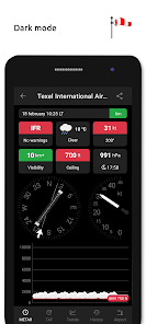
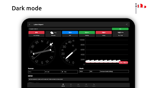
- Visualized in easy to understand and colourful metrics
- Weather symbols for significant weather and clouds, like in a non-aviation weather report
- Crosswind calculations, by combining METAR and runway information
- Flight rules category: VFR, MVFR, IFR, LIFR
- Read out by text-to-speech available, listen to a decoded METAR while doing other things
TAF features:
- TAF broken down and displayed per hour in a table
- Show sunrise/sunset, minimum and maximum temperature
Keeping track:
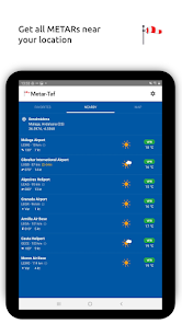
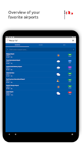
- Add your favorite stations to the list, see their weather at a glance
- Get observations near your location
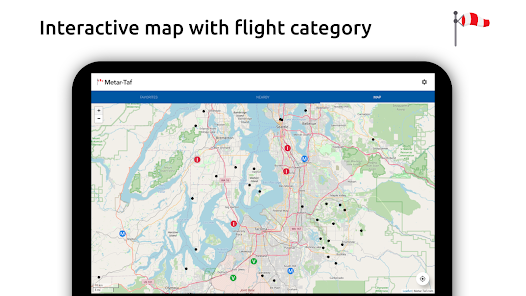
- Find stations in the interactive map with weather codes
- Search airports by ICAO code or name
History:
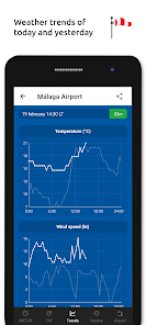
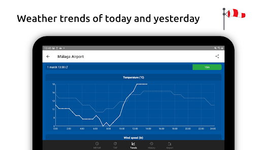
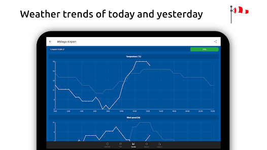
- Graphs with weather trends today and yesterday: temperature, visibility, wind speed, QNH
- METAR history for the last hours and link to more on the website
Airport information:
- See information about the airports, like runway directions, elevation, location
- If the airport doesn't report a METAR, the nearest station used for calculations
Calculations:
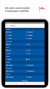
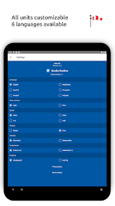
- All units are customizable units: speed (knots, km/h, m/s, mph), altitude (meters/feet), visibility (kilometers/miles), temperature (Celcius/Fahrenheit) and air pressure (Hectopascal, Inch Hg)
- Times are converted to the local time for each airport
- Sunrise and sunset are calculated based on the airports latitude/longitude
General:
- METAR, TAF and airport data are automatically saved for offline use
- Available in 6 languages: English, Dutch, Spanish, Portuguese, German and French
METAR features:
- Visualized in easy to understand and colourful metrics
- Weather symbols for significant weather and clouds, like in a non-aviation weather report
- Crosswind calculations, by combining METAR and runway information
- Flight rules category: VFR, MVFR, IFR, LIFR
- Read out by text-to-speech available, listen to a decoded METAR while doing other things
TAF features:
- TAF broken down and displayed per hour in a table
- Show sunrise/sunset, minimum and maximum temperature
Keeping track:
- Add your favorite stations to the list, see their weather at a glance
- Get observations near your location
- Find stations in the interactive map with weather codes
- Search airports by ICAO code or name
History:
- Graphs with weather trends today and yesterday: temperature, visibility, wind speed, QNH
- METAR history for the last hours and link to more on the website
Airport information:
- See information about the airports, like runway directions, elevation, location
- If the airport doesn't report a METAR, the nearest station used for calculations
Calculations:
- All units are customizable units: speed (knots, km/h, m/s, mph), altitude (meters/feet), visibility (kilometers/miles), temperature (Celcius/Fahrenheit) and air pressure (Hectopascal, Inch Hg)
- Times are converted to the local time for each airport
- Sunrise and sunset are calculated based on the airports latitude/longitude
General:
- METAR, TAF and airport data are automatically saved for offline use
- Available in 6 languages: English, Dutch, Spanish, Portuguese, German and French
Updated on
Safety starts with understanding how developers collect and share your data. Data privacy and security practices may vary based on your use, region, and age. The developer provided this information and may update it over time.

No data shared with third parties
Learn more about how developers declare sharing

No data collected
Learn more about how developers declare collection

Data is encrypted in transit

Data can’t be deleted
Ratings and reviews
4.9
840 reviews

_ (ShadowDragon246)
- Flag inappropriate
September 10, 2025
They have every single runway in Canada showing incorrectly. In Canada all runways are Magnetic headings, not True headings. They refuse to fix it. I gave up correcting them, and sending the NAV Canada's publications of every airport in Canada. Runway 10/28 for example at my airport (102°/282°) is being shown as 086°/266° I use to use this app to help me see what way the winds were blowing across the runway at the start of my shift so I could get a heads up to plan how I was plowing the runway.
Studio Eveline
September 24, 2025
Please mention the airport ID so we can have a look at it. Note that we have moved to OurAirports.com as source of airport information. Maintaining an airport database was never the intention of this project. You can post your updates on their website.

Michael Tucker
- Flag inappropriate
October 24, 2025
Can my home airport be displayed when the app is launched? Now, all I see is a list of airports and I have to select my home airport to see the data.

Phoenix Wehrly
- Flag inappropriate
October 26, 2025
great interface, easy to use, but METAR data is rather slow to update sometimes
App support
About the developer
Eveline Miranda van den Boom
studio@eveline.nl
Calle Lentisco de la Torre 1
Villa 12
29650 Mijas
Spain


