
Imray Navigator
In-app purchases
3.8star
521 reviews
100K+
Downloads

Everyone
info


About this app
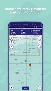
Welcome to Imray Navigator for Android
This is a basic chart plotter app.
Features:
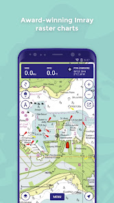
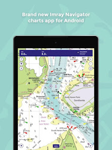
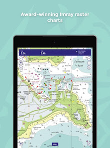
- Award-winning nautical raster charts from Imray and other Hydrographic Offices.
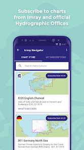
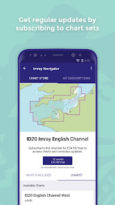
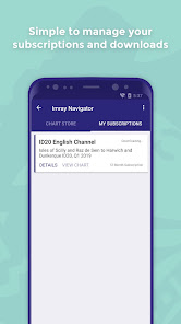
- Chart subscriptions with quarterly updates
- Data overlays including marina contact details and navigation notes
- Imray login system for sharing subscriptions across Android and Apple devices
- Routes - plot, edit, share with the crew
- GPS boat position, speed over ground, course over ground
- Tracks - plot and edit
- Waypoints - plot, edit, share with crew
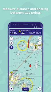
- Distance measure
Please let us know what you think by emailing support@imray.com.
This is a basic chart plotter app.
Features:
- Award-winning nautical raster charts from Imray and other Hydrographic Offices.
- Chart subscriptions with quarterly updates
- Data overlays including marina contact details and navigation notes
- Imray login system for sharing subscriptions across Android and Apple devices
- Routes - plot, edit, share with the crew
- GPS boat position, speed over ground, course over ground
- Tracks - plot and edit
- Waypoints - plot, edit, share with crew
- Distance measure
Please let us know what you think by emailing support@imray.com.
Updated on
Safety starts with understanding how developers collect and share your data. Data privacy and security practices may vary based on your use, region, and age. The developer provided this information and may update it over time.


Ratings and reviews
3.8
480 reviews

Sandy Garrity
- Flag inappropriate
- Show review history
March 3, 2023
Disappointing, I purchased a couple of charts thinking that like NV Charts I would also have access to the electronic version, but that is not how it works. Looks like you need to then purchase the same electronic chart and can only view it for a year. Tried out the demo chart, but that was so limited I gave up. Really, really disappointed with the product and would encourage Imray to look at the NV Charts app and consider using the same business model.
8 people found this review helpful

Hedley Jones
- Flag inappropriate
- Show review history
May 30, 2024
I like this app. The charts, being Imray, are really clear, and easily readable on phone or laptop. Much clearer in default settings than Navionics or similar. If I could add anything it would be WiFi access to NMEA GPS/AIS/DSC information. The other feature I would add is the ability to draw more than just 1 bearing on the chart. That would enable a user, whose GPS was not functional, to use their electronic chart in the "old fashioned" way to triangulate a position, or to draw a safety bearing
5 people found this review helpful

Ian Nethersell
- Flag inappropriate
- Show review history
September 17, 2020
Consistently unable to do anything with this app. Set up account and downloaded trial charts twice but it keeps saying error. Shame really because their paper charts and folio packs are excellent. Was hoping to give this app a go whilst bringing a boat back from Wales but looks like I'm staying with paper and Garmin. Update: Looks like the problem was with my software, which is now resolved. Imray have been super helpful and understanding trying to sort it with me, can't fault them.
22 people found this review helpful
Imray, Laurie, Norie and Wilson Ltd
September 17, 2020
Hi Ian, thanks for your review. I believe, after some work at both ends, we have fixed this so would it be possible for you to update your rating please? Thanks
What’s new
In this minor release, we have fixed some bugs to improve the stability of the application.
App support
About the developer
IMRAY,LAURIE,NORIE & WILSON,LIMITED
support@imray.com
Wych House 20 The Broadway, St Ives
ST. IVES
PE27 5BT
United Kingdom
+44 7787 854468


