
Hawk Map GPS-GIS
Contains ads
4.5star
1.17K reviews
100K+
Downloads

Teen
info


About this app
GPS and coordinate systems helper especially for military personnel.
It is also a complete helper for airsoft, mountaineering, trekking and hiking, cross running, scouting, hunting, fishing, geocaching, off-road navigation and all other outdoor activities and sports.
With satellite navigation systems such as GPS, GALILEO and GLONASS (GNSS) supported by your device and your sensors, you can see your most accurate position on different map layers.
⭐⭐Features⭐⭐
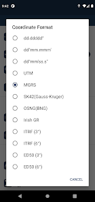
👉 Coordinate Indicator, finder and converter
Format options:
- D°M'S" (WGS84)
- Latitude/Longitude (WGS84)
- UTM (WGS84/NAD83),
- MGRS / U.S. National Grid (USNG) (WGS84/NAD83)
- SK42(Gauss Kruger)
- British National Grid(BNG-OSNG)
- Irish Grid Reference
- ED50 (6°-3°)
- ITRF (6°-3°)
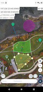
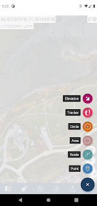
👉 You can make colored markings on the map.
Markers,Polygons,Polylines,Circles
👉 Area & Distance measurement
Distance unit options: m , ft , mi , yd , nmi
Area unit options: m² , ha , ft², yd², mi²
👉 Elevation information
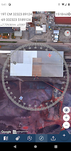
👉 Compass
Angular unit options: Degrees ,NATO mil, Warsaw Mil, Grad
👉 Map style options: (Road,Terrain,Satellite,Night Mode,Hybrid)
👉 KML viewer. (Export and import KML layers).
👉 GPS track recorder.
It is also a complete helper for airsoft, mountaineering, trekking and hiking, cross running, scouting, hunting, fishing, geocaching, off-road navigation and all other outdoor activities and sports.
With satellite navigation systems such as GPS, GALILEO and GLONASS (GNSS) supported by your device and your sensors, you can see your most accurate position on different map layers.
⭐⭐Features⭐⭐
👉 Coordinate Indicator, finder and converter
Format options:
- D°M'S" (WGS84)
- Latitude/Longitude (WGS84)
- UTM (WGS84/NAD83),
- MGRS / U.S. National Grid (USNG) (WGS84/NAD83)
- SK42(Gauss Kruger)
- British National Grid(BNG-OSNG)
- Irish Grid Reference
- ED50 (6°-3°)
- ITRF (6°-3°)
👉 You can make colored markings on the map.
Markers,Polygons,Polylines,Circles
👉 Area & Distance measurement
Distance unit options: m , ft , mi , yd , nmi
Area unit options: m² , ha , ft², yd², mi²
👉 Elevation information
👉 Compass
Angular unit options: Degrees ,NATO mil, Warsaw Mil, Grad
👉 Map style options: (Road,Terrain,Satellite,Night Mode,Hybrid)
👉 KML viewer. (Export and import KML layers).
👉 GPS track recorder.
Updated on
Safety starts with understanding how developers collect and share your data. Data privacy and security practices may vary based on your use, region, and age. The developer provided this information and may update it over time.


Ratings and reviews
4.5
1.14K reviews

L Jones
- Flag inappropriate
- Show review history
March 14, 2021
I'm using Galaxy S10 - I see the reviews about crashing, but so far it has not crashed for me, however, I have been unable to export/import. I click "export as", name it, click ok and "export as" box remains. The XML list remains empty and when I click the plus sign nothing happens. I am still learning the "convert and find" function. This is day one of use, I will keep checking it. *UPDATE I allowed storage permission and export/import is working.
19 people found this review helpful
DakikTech
March 14, 2021
Hi Jines,
Thanks for your rewiev and feedback

A Google user
- Flag inappropriate
March 13, 2021
Crashed almost immediately and caused my phone (Samsung a50) to restart. I really like the old version and use it all the time out in the bush. If the issues are sorted out this will likely be a great gps app as the older one was excellent for what it is. Looking forward to seeing this fixed and trying it again, until then I do not recommend this.
12 people found this review helpful
DakikTech
March 14, 2021
Hi.
This situation was due to you denied location permission. I hope I fixed the problem. Please update and try.

Daniel Wind
- Flag inappropriate
October 21, 2022
Wish I landed on this one first. Vary new to this and has been by far the best app I came across yet. Wanted to create a map of a search area for a missing person. This has everything thing I need on just the basic version and my maps caught up. Love this app
3 people found this review helpful
App support
About the developer
Zahid Çataltaş
zhdctlts@gmail.com
İstiklal mahallesi, 1170 sokak, no:18, daire 6, Pamukkale , Denizli
Cinkaya Yapı 1
20000 Ege/Denizli
Türkiye
undefined


