

VFRnav flight navigation

100 hilj.+
Preuzimanja

Svako
info


O aplikaciji
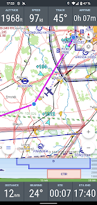
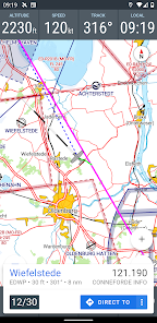
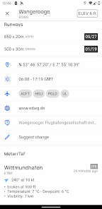
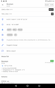
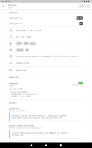
The integrated database includes airfields from Germany, Austria, Switzerland as well as BeNeLux, France, Italy, the Czech Republic and Poland and many other countries with information about name, frequency and runway data.
After the setup, VFRnav works completely offline and does not need an existing data connection for navigation at any time.
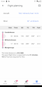
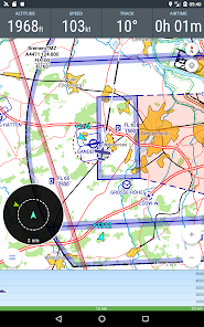
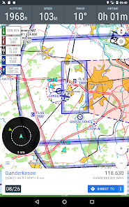
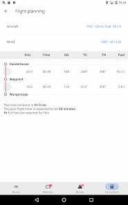
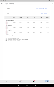
The integrated flight planning helps with route planning, the calculation of fuel and flight times and automatically provides information about flight weather (metar & taf) and notams enroute.
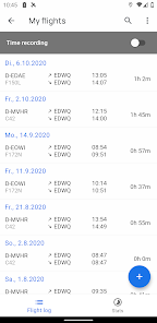
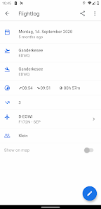
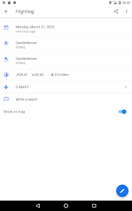
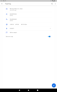
The flight log enables the digital recording of your flights. Thanks to the automatic flight time recording, all flights are automatically recorded. Tracks can be exported as KML files and sent by email. Flown routes can thus be easily displayed e.g. on Google Maps.
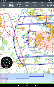
For high requirements, VFRnav can process position data from external GPS receivers via Wifi or Bluetooth. Traffic data is also processed and displayed directly on the map. VFRnav works with many FLARM and ADS-B devices. Stratux is also supported.
The development of VFRnav takes place in close contact with pilots in europe. In the current version 3, many ideas and suggestions have been implemented that have reached us by e-mail in the past few months. Many thanks at this point for all the feedback.
VFRnav is compatible with traffic data sources such as SafeSky, CCAS, Stratux, AT-01, FLARM, etc.
All functions of VFRnav can be tested without restrictions. If you like VFRnav, you can purchase a license for 49.95 €. You will receive all updates free of charge for one year. After 12 months have expired, the update period can be extended for just 29.80 €. However, VFRnav itself can run indefinitely.
By the way: The license is personal, but not device-specific. If you use several Android devices under the same Google account, the full version is available on all devices (maximum of three devices).
Note: For the map and airspace display, at least 200MB of free storage space must be available. Compatible with devices from Android 5. A minimum resolution of 480x800 pixels is recommended.
Disclaimer of liability: Please note that VFRnav is not an officially approved aid for flight preparation and execution. A guarantee for the correctness and completeness of the data is excluded. Please always check the data displayed with official aviation maps.
After the setup, VFRnav works completely offline and does not need an existing data connection for navigation at any time.
The integrated flight planning helps with route planning, the calculation of fuel and flight times and automatically provides information about flight weather (metar & taf) and notams enroute.
The flight log enables the digital recording of your flights. Thanks to the automatic flight time recording, all flights are automatically recorded. Tracks can be exported as KML files and sent by email. Flown routes can thus be easily displayed e.g. on Google Maps.
For high requirements, VFRnav can process position data from external GPS receivers via Wifi or Bluetooth. Traffic data is also processed and displayed directly on the map. VFRnav works with many FLARM and ADS-B devices. Stratux is also supported.
The development of VFRnav takes place in close contact with pilots in europe. In the current version 3, many ideas and suggestions have been implemented that have reached us by e-mail in the past few months. Many thanks at this point for all the feedback.
VFRnav is compatible with traffic data sources such as SafeSky, CCAS, Stratux, AT-01, FLARM, etc.
All functions of VFRnav can be tested without restrictions. If you like VFRnav, you can purchase a license for 49.95 €. You will receive all updates free of charge for one year. After 12 months have expired, the update period can be extended for just 29.80 €. However, VFRnav itself can run indefinitely.
By the way: The license is personal, but not device-specific. If you use several Android devices under the same Google account, the full version is available on all devices (maximum of three devices).
Note: For the map and airspace display, at least 200MB of free storage space must be available. Compatible with devices from Android 5. A minimum resolution of 480x800 pixels is recommended.
Disclaimer of liability: Please note that VFRnav is not an officially approved aid for flight preparation and execution. A guarantee for the correctness and completeness of the data is excluded. Please always check the data displayed with official aviation maps.
Ažurirano dana
Sigurnost počinje razumijevanjem na koji način programeri prikupljaju i dijele vaše podatke. Privatnost podataka i sigurnosne prakse se mogu razlikovati ovisno o korištenju, regiji i dobi. Programer je naveo ove informacije i može ih s vremenom ažurirati.

Podaci se ne dijele s trećim stranama
Saznajte više o načinu na koji programeri pružaju izjavu o dijeljenju

Ova aplikacija može prikupljati ove vrste podataka
Lične informacije

Podaci se šifriraju tokom prenosa

Možete zatražiti da se podaci izbrišu
Šta ima novo
v4.4.0
New: DFS AIP links in airport screen added
New: chart sheet option to remove a chart from map
New: SR and SS times added
New: support for rotated charts
Fix: Airspace list misses some airspaces
Fix: widget cannot be set to "END"
Fix: black screen while loading DFS charts
improved excel time parsing
minor bug fixes
minor ui changes
Podrška za aplikaciju
Informacije o programeru
Hermann Hölter
mail@flugbetrieb.com
Vörreeg 6
27804 Berne
Germany
+49 4406 9572948


