
Earthquakes
Sadržava oglaseKupovina unutar aplikacije
4,2star
2,31 hilj. recenzija
500 hilj.+
Preuzimanja

Svako
info


O aplikaciji
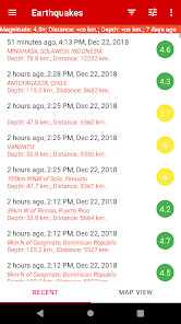
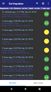
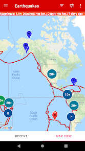
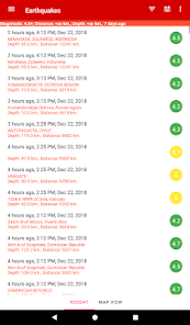
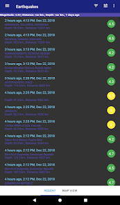
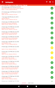
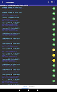
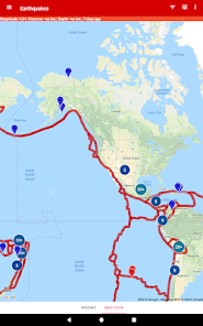
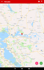
This mobile application is designed for users who are interested in staying informed about the latest earthquakes around the world. The app features a database of the latest earthquakes, which can be displayed in a list and on a map. The list view allows users to see the location, magnitude, and time of each earthquake, while the map view provides a visual representation of the earthquakes' locations.
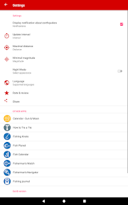
Users can filter the list of earthquakes based on strength, distance from their current location, and depth. This makes it easier for users to find earthquakes that are relevant to them, and to see how close earthquakes are to their current location.
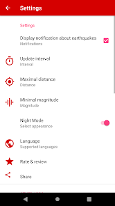
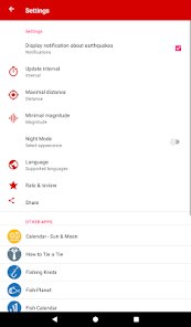
The app also includes an alert feature that notifies users about new earthquakes in real-time. This feature can be turned on or off, and users can choose to receive alerts for earthquakes of a certain magnitude or within a certain distance from their current location.
Whether you're a scientist, a geology enthusiast, or just someone who wants to stay informed about earthquakes, this app is for you.
In addition to the list and map views, this application also provides detailed information about each earthquake, including its depth, magnitude, and intensity. Users can also access a history of past earthquakes, which allows them to track the frequency and distribution of earthquakes over time.
Another great feature of Earthquake Alert is its ability to display earthquakes on a map using satellite imagery. This provides users with a visual representation of the earthquakes' locations, and makes it easy to see the proximity of earthquakes to populated areas.
Also the map shows the boundaries of tectonic plates on which earthquakes occur, it is possible to assess the dangerous and safe countries and regions of the planet.
Data on earthquakes are taken from the official “USGS” program, “European seismic program” - “EMSC” and “New Zealand GeoNet service”.
Users can filter the list of earthquakes based on strength, distance from their current location, and depth. This makes it easier for users to find earthquakes that are relevant to them, and to see how close earthquakes are to their current location.
The app also includes an alert feature that notifies users about new earthquakes in real-time. This feature can be turned on or off, and users can choose to receive alerts for earthquakes of a certain magnitude or within a certain distance from their current location.
Whether you're a scientist, a geology enthusiast, or just someone who wants to stay informed about earthquakes, this app is for you.
In addition to the list and map views, this application also provides detailed information about each earthquake, including its depth, magnitude, and intensity. Users can also access a history of past earthquakes, which allows them to track the frequency and distribution of earthquakes over time.
Another great feature of Earthquake Alert is its ability to display earthquakes on a map using satellite imagery. This provides users with a visual representation of the earthquakes' locations, and makes it easy to see the proximity of earthquakes to populated areas.
Also the map shows the boundaries of tectonic plates on which earthquakes occur, it is possible to assess the dangerous and safe countries and regions of the planet.
Data on earthquakes are taken from the official “USGS” program, “European seismic program” - “EMSC” and “New Zealand GeoNet service”.
Ažurirano dana
Sigurnost počinje razumijevanjem na koji način programeri prikupljaju i dijele vaše podatke. Privatnost podataka i sigurnosne prakse se mogu razlikovati ovisno o korištenju, regiji i dobi. Programer je pružio ove informacije i može ih s vremenom ažurirati.


Ocjene i recenzije
4,2
2,24 hilj. recenzija

Danijela Tomic
- Označavanje kao neprikladno
8. februar 2023.
Sad sam instalirao al vidim.da je ok
2 osobe smatraju ovu recenziju korisnom
Šta ima novo
- fix location search
- add location history
- add location history


