OSMTracker for Android™
3.8star
268 reviews
50K+
Downloads

Everyone
info
About this app
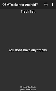
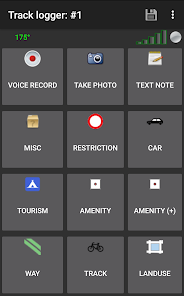
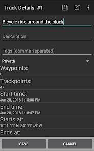
Inspired by OSMTracker for Windows Mobile, allows you to track your journeys, mark waypoints with tags, voice record, and photos.
GPS traces can then be exported in GPX format for later use with OpenStreetMap tools like JOSM, or uploaded directly to OpenStreetMap.
Tracks can be displayed over an OpenStreetMap background or with no background if you don't have a data plan.
Project page: https://github.com/labexp/osmtracker-android
Please visit the project page to report an issue or get more information.
Help translate OSMTracker: https://www.transifex.com/projects/p/osmtracker-android/
Source code: https://github.com/labexp/osmtracker-android
Permissions
• Fine location: Access the GPS
• Record audio: Record an audio tag
• Internet & network state: Display map background and upload to OpenStreetMap
• WiFi state: Get coarse location
• Write to SD card: GPX export
Updated on
Safety starts with understanding how developers collect and share your data. Data privacy and security practices may vary based on your use, region, and age. The developer provided this information and may update it over time.


Ratings and reviews
3.9
260 reviews

Joe Kazimierczyk
- Flag inappropriate
March 21, 2023
The controls are not very easy to figure out. I have a hard time figuring out how to stop a recording in progress. I don't know what most of the controls on the main screen are for. It's not intuitive how to save your GPX recording somewhere. I tracks well, but doesn't show anything like distance covered, elevation, etc. I guess this app is meant for uploading data to OSM, but it's not great for a general purpose GPS tracker for hiking or cycling.
2 people found this review helpful

Dan Roitner
- Flag inappropriate
February 28, 2023
A simple straight forward GPS tracking app. I use it for MTB riding and Nordic skiing for years. Fairly accurate and locks onto the GPS signal better than other apps I have used. Does not drain my battery too fast. You can mark waypoints, and take photos at those spots for reference. Others use it for plotting maps on OSM. I have no time for that but the tools are there.
3 people found this review helpful

Jaakko Karhu
- Flag inappropriate
August 15, 2024
Photos are not stored anywhere, or if they are, they are so hard to find that I am running out of ideas. Just lost all of the photos I took on my 100km+ tour. I recommend using something more reliable. If I am wrong and the photos are accessible after all, will change this review.
What’s new
Bug fixes: Warn user when no photo or audio app is installed (for waypoints preview).
New feature: Upload tracks to GitHub. Auto-rename duplicates.
Language translation updates (thanks translators!)
New feature: Upload tracks to GitHub. Auto-rename duplicates.
Language translation updates (thanks translators!)
App support
About the developer
Jaime Gutiérrez Alfaro
contacto@labexp.org
Costa Rica
undefined


