
渋滞情報
Contains ads
1K+
Downloads

Everyone
info


About this app
現在位置の渋滞情報を地図(通常地図、衛星写真、地形図)に表示します、広域情報、雨雲レーダー、出発ICから到着ICまでのルート上の規制・渋滞情報も表示します。
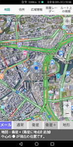
1.地図は、通常の地図、衛星写真、衛星写真に地名を加えたもの、地形図の4種類が表示します。道路の渋滞箇所は赤字で表示します。[メール]をタッチすると地図情報(緯度、経度)のURLと住所をメールで送ることができます。
2.住所は、現在位置の緯度、経度、国コード、国名、郵便番号、都道府県、市区町村、市区町村のヨミ、町、町のヨミ、丁目、番地、号・建物を表示します。
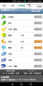
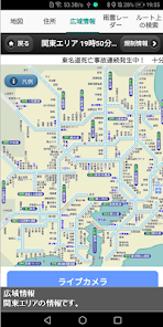
3.広域情報は、全国の交通状況マップを表示します。
4.雨雲レーダーは、最新の雨雲の発生状況を表示します。レーダーの縮尺は5~15で、5が広域で日本全土、15が狭域で近所になります。[+]は現在位置です。
5.ルート上の検索は、出発ICから到着ICまでのルート上の規制・渋滞情報を表示します。
1.地図は、通常の地図、衛星写真、衛星写真に地名を加えたもの、地形図の4種類が表示します。道路の渋滞箇所は赤字で表示します。[メール]をタッチすると地図情報(緯度、経度)のURLと住所をメールで送ることができます。
2.住所は、現在位置の緯度、経度、国コード、国名、郵便番号、都道府県、市区町村、市区町村のヨミ、町、町のヨミ、丁目、番地、号・建物を表示します。
3.広域情報は、全国の交通状況マップを表示します。
4.雨雲レーダーは、最新の雨雲の発生状況を表示します。レーダーの縮尺は5~15で、5が広域で日本全土、15が狭域で近所になります。[+]は現在位置です。
5.ルート上の検索は、出発ICから到着ICまでのルート上の規制・渋滞情報を表示します。
Updated on
Safety starts with understanding how developers collect and share your data. Data privacy and security practices may vary based on your use, region, and age. The developer provided this information and may update it over time.

No data shared with third parties
Learn more about how developers declare sharing

No data collected
Learn more about how developers declare collection
What’s new
雨雲レーダー修正
App support
About the developer
FNDXTECH
fndxtech@gmail.com
5-7, KITAYAMATA, TSUZUKI-KU
YOKOHAMA, 神奈川県 224-0021
Japan
+81 90-6841-9420


