
APAIMS
1 Tsg.+
Downloads

Jedes Alter
info
Über diese App
The State of Andhra Pradesh has Agriculture as one the major contributors to GVA.
Out of the total geographical area of 1.6 Lakh Hectares, 80 Lakh Hectares(net) is
cultivable area and 50% of that is under rainfed cultivation. Due to deficit rainfall,
changing rainfall patterns and climate change, farmers growing rainfed crops are
routinely faced with yield loss and crop failures due to soil moisture stress. Pest
infestation is the other factor that is linked to lower crop yields.
Agriculture Department is interested in using technology to make better informed
and timely decisions. Some goals of this project include:
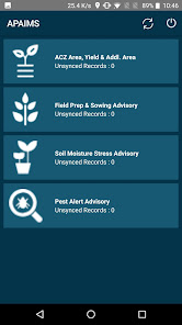
1. Raising timely advisories to MPEOs to be eventually communicated to the
farmers to help in decision making and interventions
2. Agriculture analytics built on the existing soil health card and crop sown
analytics to enable decision makers with actionable insights
3. Drought manual automation to equip department with early season drought
advisory to take necessary action
4. Web Geo-Portal to bring all agriculture related information and assets into one
common geo-portal
Out of the total geographical area of 1.6 Lakh Hectares, 80 Lakh Hectares(net) is
cultivable area and 50% of that is under rainfed cultivation. Due to deficit rainfall,
changing rainfall patterns and climate change, farmers growing rainfed crops are
routinely faced with yield loss and crop failures due to soil moisture stress. Pest
infestation is the other factor that is linked to lower crop yields.
Agriculture Department is interested in using technology to make better informed
and timely decisions. Some goals of this project include:
1. Raising timely advisories to MPEOs to be eventually communicated to the
farmers to help in decision making and interventions
2. Agriculture analytics built on the existing soil health card and crop sown
analytics to enable decision makers with actionable insights
3. Drought manual automation to equip department with early season drought
advisory to take necessary action
4. Web Geo-Portal to bring all agriculture related information and assets into one
common geo-portal
Aktualisiert am
Was die Sicherheit angeht, solltest du als Erstes verstehen, wie Entwickler deine Daten erheben und weitergeben. Die Datenschutz- und Sicherheitspraktiken können je nach deiner Verwendung, deiner Region und deinem Alter variieren. Diese Informationen wurden vom Entwickler zur Verfügung gestellt und können jederzeit von ihm geändert werden.

Keine Daten werden mit Drittunternehmen oder -organisationen geteilt

Diese App kann die folgenden Datentypen erheben
Standort, Fotos und Videos und App-Informationen und -Leistung

Daten werden nicht verschlüsselt
Daten können nicht gelöscht werden
Neuigkeiten
Bug fixes and Optimisations


