
onX Hunt: GPS Hunting Maps
In-App-Käufe
4.7star
52 Tsg. Rezensionen
5 Mio.+
Downloads

Jedes Alter
info


Über diese App
onX Hunt is a fully-functioning GPS navigation app on your phone. View private and public property land ownership data, landowner names, and property lines on your custom maps. Easily view hunting units, roads and trails, U.S. topographic maps, and more.
New features including Aerial imagery, Compass Mode with Rangefinder, and Trail Camera Integration ensure onX is your go-to tool for this hunting season and beyond. Our new Two-State Premium Membership allows you to have full access to all onX features in two states, ideal for hunters who cross state lines.
▶Government Information
onXmaps, Inc. does not represent any government or political entity, though you may find various links to public information within our services. For more info on any government information found within the services, click on the associated .gov link.
▶ FREE TRIAL:
While the onX Hunt App and many of its features are free, you’ll start a free Premium State Membership trial when you install the App. This allows you to try a full-featured Premium State Membership for seven days.
▶ FREE HUNTING APP FEATURES:
• NO ADS
• Satellite Maps and 24K Topographical Maps with GPS Navigation
• Local weather conditions, forecasts, wind speeds, and wind direction
• Aerial / Topo Hybrid overlay to see contours with satellite imagery
• Hunting Zones, Areas, or Game Management Units (GMU) for game species in all 50 states
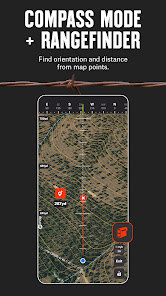
• New Compass Mode with Rangefinder: find orientation and distance from map points
• Mark Waypoints with custom icons for camps, vehicles, and more
• Measure distances with the Line Tool
• Track the distance, coordinates, duration, and speed of your hunt with Tracker
▶ OFFLINE GPS FUNCTIONALITY:
Turn your phone into an outdoor handheld GPS navigator using the built-in GPS to display your location on the map. Cellular coverage is NOT needed as tile-saving technology allows you to save basemaps and layers for offline navigation.
▶ DESKTOP MAPS: Memberships also include access to our online Web Hunting Map (www.onxmaps.com/web).
• Scout from the comfort of your home
• Sync markups and tracks between devices
• Print unlimited free maps
▶ PREMIUM SINGLE-STATE MEMBERSHIP:
This membership costs $34.99/year. Get all the great features of the free onX Hunt App PLUS the additional benefits of:
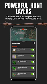
• Public land like Forest Service, Bureau of Land Management (BLM maps), Wildlife Management Areas, county and state land hunting maps, Timber Lands, and more
• 3D maps on phone and desktop
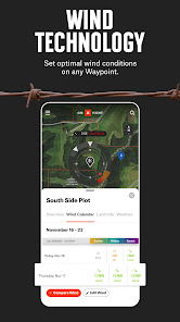
• Optimal Wind and Wind Calendar for stand locations and hunt planning
• Landowner names with property line maps and land boundaries finder in available counties (U.S. only)
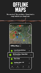
• Save private or public hunting land maps for offline use
• GMU or Hunting Units for multiple species
• Possible Access Lands, Walk-In Areas, Block Management Areas, and private lands open to the public
* Private land ownership maps may not be available for all counties (U.S. only)
▶ PREMIUM TWO-STATE MEMBERSHIP:
With a Premium Two-State Membership, you get all the benefits of our Premium Single-State Membership, but for two states. A Premium Two-State Membership costs $49.99/year and gets you all the great features of the free onX Hunt App PLUS the additional benefits listed above.
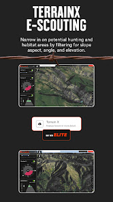
▶ ELITE NATIONWIDE MEMBERSHIP:
The best tool for the best hunters. With an Elite Membership, you get a complete, purpose-built solution for dedicated hunters and the game they pursue, including:
• Proprietary maps for all 50 states
• Advanced Tools: TerrainX 3D, Recent Imagery, Route Builder
• Elite-exclusive pro deals and expert resources
• Available for $99.99/year or $14.99/month.
▶onX HUNT GOVERNMENT DATA SOURCES:
https://data.fs.usda.gov/geodata/
https://gbp-blm-egis.hub.arcgis.com/
https://www.arcgis.com/home/group.html?id=00f2977287f74c79aad558708e3b6649#overview
▶ TERMS OF USE:
https://www.onxmaps.com/tou
▶ FEEDBACK:
Have a problem or want to request new features? Please contact us at support@onxmaps.com
New features including Aerial imagery, Compass Mode with Rangefinder, and Trail Camera Integration ensure onX is your go-to tool for this hunting season and beyond. Our new Two-State Premium Membership allows you to have full access to all onX features in two states, ideal for hunters who cross state lines.
▶Government Information
onXmaps, Inc. does not represent any government or political entity, though you may find various links to public information within our services. For more info on any government information found within the services, click on the associated .gov link.
▶ FREE TRIAL:
While the onX Hunt App and many of its features are free, you’ll start a free Premium State Membership trial when you install the App. This allows you to try a full-featured Premium State Membership for seven days.
▶ FREE HUNTING APP FEATURES:
• NO ADS
• Satellite Maps and 24K Topographical Maps with GPS Navigation
• Local weather conditions, forecasts, wind speeds, and wind direction
• Aerial / Topo Hybrid overlay to see contours with satellite imagery
• Hunting Zones, Areas, or Game Management Units (GMU) for game species in all 50 states
• New Compass Mode with Rangefinder: find orientation and distance from map points
• Mark Waypoints with custom icons for camps, vehicles, and more
• Measure distances with the Line Tool
• Track the distance, coordinates, duration, and speed of your hunt with Tracker
▶ OFFLINE GPS FUNCTIONALITY:
Turn your phone into an outdoor handheld GPS navigator using the built-in GPS to display your location on the map. Cellular coverage is NOT needed as tile-saving technology allows you to save basemaps and layers for offline navigation.
▶ DESKTOP MAPS: Memberships also include access to our online Web Hunting Map (www.onxmaps.com/web).
• Scout from the comfort of your home
• Sync markups and tracks between devices
• Print unlimited free maps
▶ PREMIUM SINGLE-STATE MEMBERSHIP:
This membership costs $34.99/year. Get all the great features of the free onX Hunt App PLUS the additional benefits of:
• Public land like Forest Service, Bureau of Land Management (BLM maps), Wildlife Management Areas, county and state land hunting maps, Timber Lands, and more
• 3D maps on phone and desktop
• Optimal Wind and Wind Calendar for stand locations and hunt planning
• Landowner names with property line maps and land boundaries finder in available counties (U.S. only)
• Save private or public hunting land maps for offline use
• GMU or Hunting Units for multiple species
• Possible Access Lands, Walk-In Areas, Block Management Areas, and private lands open to the public
* Private land ownership maps may not be available for all counties (U.S. only)
▶ PREMIUM TWO-STATE MEMBERSHIP:
With a Premium Two-State Membership, you get all the benefits of our Premium Single-State Membership, but for two states. A Premium Two-State Membership costs $49.99/year and gets you all the great features of the free onX Hunt App PLUS the additional benefits listed above.
▶ ELITE NATIONWIDE MEMBERSHIP:
The best tool for the best hunters. With an Elite Membership, you get a complete, purpose-built solution for dedicated hunters and the game they pursue, including:
• Proprietary maps for all 50 states
• Advanced Tools: TerrainX 3D, Recent Imagery, Route Builder
• Elite-exclusive pro deals and expert resources
• Available for $99.99/year or $14.99/month.
▶onX HUNT GOVERNMENT DATA SOURCES:
https://data.fs.usda.gov/geodata/
https://gbp-blm-egis.hub.arcgis.com/
https://www.arcgis.com/home/group.html?id=00f2977287f74c79aad558708e3b6649#overview
▶ TERMS OF USE:
https://www.onxmaps.com/tou
▶ FEEDBACK:
Have a problem or want to request new features? Please contact us at support@onxmaps.com
Aktualisiert am
Was die Sicherheit angeht, solltest du als Erstes verstehen, wie Entwickler deine Daten erheben und weitergeben. Die Datenschutz- und Sicherheitspraktiken können je nach deiner Verwendung, deiner Region und deinem Alter variieren. Diese Informationen wurden vom Entwickler zur Verfügung gestellt und können jederzeit von ihm geändert werden.


Bewertungen und Rezensionen
4.7
50.7 Tsg. Rezensionen
Neuigkeiten
Introducing the new “Mark My Location” feature for onX Hunt for Wear OS! With just one tap, you can instantly drop a waypoint from your wrist, seamlessly syncing to the onX Hunt app on your phone. This game-changing tool allows you to stay focused on the hunt without needing to look at your phone, enhancing both your efficiency and safety in the field.


