
Runplanner: Running route plan


전체이용가
info
1만+
다운로드

전체이용가
자세히 알아보기


앱 정보
Most apps draw a straight line and call it a running route planner. Runplanner actually understands runners — your route snaps to real roads, paths, and cycleways.
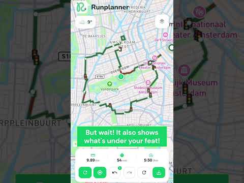
Tap waypoints on the map and Runplanner builds a route along the streets and trails that are actually there. You see your real distance, a proper elevation profile, and a breakdown of what surface you're running on, before you leave the house. Free, no account, no ads.
🚦 Traffic Light Detection
Runplanner detects and shows traffic lights along your running route on the map. Know exactly where your natural pause points are — useful for intervals, tempo runs, or planning a route where you won't be stuck waiting at every crossing.
🔄 Roundtrip Generator
Tell Runplanner how far you want to run and it builds a loop route back to your starting point. Good for training days when you want a distance, not a destination.
🗺️ Runner-First Routing
Footpaths and cycleways take priority over busy car roads. Surface awareness tells you whether you're heading onto tarmac, gravel, or trail — no surprises.
📅 Schedule Your Runs
Plan future runs in the built-in calendar and get a notification on the day. Turn Runplanner into your running route planner and your training calendar in one app.
🏋️ Workout Plans
Build structured training sessions directly on your route — warm-up, intervals, cool-down — with custom pace zones for each segment.
Start your run and follow along with live turn-by-turn navigation: street names, turn directions, and an alert when you go off-route.
🌤️ Weather Check
See the forecast before you head out. Know whether to bring a jacket before you've laced up.
📊 Route Metrics
Distance, estimated duration, pace, elevation, and road type breakdown update in real time as you plan your running route.
📁 GPX Import & Export
Export any route as a GPX file for Garmin, Apple Watch, Coros, or Strava. Import existing GPX files into Runplanner with one tap.
🔗 Share Routes
Share routes with friends via QR code or link. They scan, you both run the same route.
👟 Gear Tracking
Log which shoes you ran in. Track mileage on each pair so you know when it's time to replace them.
🔒 Privacy First
No account required. No ads. No subscriptions. Your routes and activities are stored locally on your device with AES-256 encryption.
We don't track you, sell your data, or push you toward a premium tier.
Free running route planner. No paid tier. Built by runners, for runners.
👉 runplannerapp.com
Tap waypoints on the map and Runplanner builds a route along the streets and trails that are actually there. You see your real distance, a proper elevation profile, and a breakdown of what surface you're running on, before you leave the house. Free, no account, no ads.
🚦 Traffic Light Detection
Runplanner detects and shows traffic lights along your running route on the map. Know exactly where your natural pause points are — useful for intervals, tempo runs, or planning a route where you won't be stuck waiting at every crossing.
🔄 Roundtrip Generator
Tell Runplanner how far you want to run and it builds a loop route back to your starting point. Good for training days when you want a distance, not a destination.
🗺️ Runner-First Routing
Footpaths and cycleways take priority over busy car roads. Surface awareness tells you whether you're heading onto tarmac, gravel, or trail — no surprises.
📅 Schedule Your Runs
Plan future runs in the built-in calendar and get a notification on the day. Turn Runplanner into your running route planner and your training calendar in one app.
🏋️ Workout Plans
Build structured training sessions directly on your route — warm-up, intervals, cool-down — with custom pace zones for each segment.
Start your run and follow along with live turn-by-turn navigation: street names, turn directions, and an alert when you go off-route.
🌤️ Weather Check
See the forecast before you head out. Know whether to bring a jacket before you've laced up.
📊 Route Metrics
Distance, estimated duration, pace, elevation, and road type breakdown update in real time as you plan your running route.
📁 GPX Import & Export
Export any route as a GPX file for Garmin, Apple Watch, Coros, or Strava. Import existing GPX files into Runplanner with one tap.
🔗 Share Routes
Share routes with friends via QR code or link. They scan, you both run the same route.
👟 Gear Tracking
Log which shoes you ran in. Track mileage on each pair so you know when it's time to replace them.
🔒 Privacy First
No account required. No ads. No subscriptions. Your routes and activities are stored locally on your device with AES-256 encryption.
We don't track you, sell your data, or push you toward a premium tier.
Free running route planner. No paid tier. Built by runners, for runners.
👉 runplannerapp.com
Plan running routes on real paths, generate loops, navigate and export GPX.
업데이트 날짜
추천 스토리


새로운 기능
What's new in version 1.3.8
• 3D showcase on the route detail map: the camera flies around your whole route
• New animated confirmation when you save a route
• Route planning no longer stalls when a routing server is unreachable
• More accurate distance calculations
• Fixed several crashes on the map and route screens
• 3D showcase on the route detail map: the camera flies around your whole route
• New animated confirmation when you save a route
• Route planning no longer stalls when a routing server is unreachable
• More accurate distance calculations
• Fixed several crashes on the map and route screens


