Trailblazer Navigator Pro
Contient des annoncesAchats via l'appli
4,2star
981 avis
100K+
Téléchargements

Tout public
info


À propos de l'application
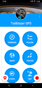
Use Trailblazer Navigator Pro to display tracks and waypoints in KML and KMZ files, then navigate them with the app's offline and online maps. Download a map before traveling beyond network reach and use it to keep you oriented anywhere on the planet! Record your hikes, runs and bike rides with the app's track recorder and create waypoints with the app's location logging tools.
Maps
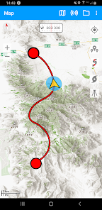
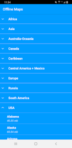
Trailblazer Navigator Pro has maps for every situation. Explore mountains and national parks with topographic and hiking maps. Find and explore biking trails with our cycle maps and navigate coastal areas with NOAA nautical charts. Our offline maps are perfect for back country hiking and cycling. Offline maps can be downloaded and transferred to the SD card to save phone memory.
In keeping with our company's pledge to make our downloadable maps available to the most number of people, all maps are available free without any limits on downloads.
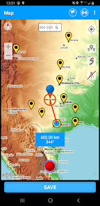
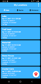
View your previously recorded trails and waypoints on any map or add trails and waypoints from a kml or kmz file. All maps have custom built-in compasses and measurement tools to enhance your location awareness.
Location Recorder
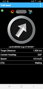
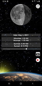
Save your current location, enter coordinates or use a map to create a waypoint. Multiple coordinate formats including UTM can be entered. Navigate to any saved location using maps or the app's location-finding compass where you simply follow the arrow along a straight line course to your waypoint.
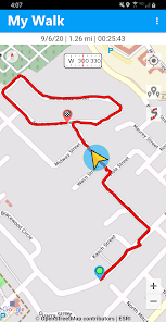
Trail Navigation
Record a track and follow it on your return trip or navigate along a trail included on the maps.
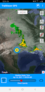
Weather Maps
• Animated Live Doppler Weather Radar.
• Weather Satellite Layer (visible clouds and infrared imaging).
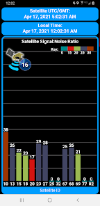
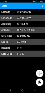
GPS Parameters and GPS Signal Diagnostics
Navigation accuracy is only as good as the information that comes from your GPS chip. Use the app's GPS reports to understand the accuracy of your location information and the quality of the GPS signals received by your phone. For our more technically oriented users, the app offers graphs and charts that describe GPS signal quality and satellite location in greater detail.
Compasses
Magnetic compasses, GPS controlled compasses and waypoint compasses are all there to give you that extra bit of navigation information that cannot be provided by a map alone. All magnetic compasses feature gyroscopic stabilization on compatible devices for super smooth operation.
Explore the app and you will be surprised by the number of useful navigation tools that are available!
Maps
Trailblazer Navigator Pro has maps for every situation. Explore mountains and national parks with topographic and hiking maps. Find and explore biking trails with our cycle maps and navigate coastal areas with NOAA nautical charts. Our offline maps are perfect for back country hiking and cycling. Offline maps can be downloaded and transferred to the SD card to save phone memory.
In keeping with our company's pledge to make our downloadable maps available to the most number of people, all maps are available free without any limits on downloads.
View your previously recorded trails and waypoints on any map or add trails and waypoints from a kml or kmz file. All maps have custom built-in compasses and measurement tools to enhance your location awareness.
Location Recorder
Save your current location, enter coordinates or use a map to create a waypoint. Multiple coordinate formats including UTM can be entered. Navigate to any saved location using maps or the app's location-finding compass where you simply follow the arrow along a straight line course to your waypoint.
Trail Navigation
Record a track and follow it on your return trip or navigate along a trail included on the maps.
Weather Maps
• Animated Live Doppler Weather Radar.
• Weather Satellite Layer (visible clouds and infrared imaging).
GPS Parameters and GPS Signal Diagnostics
Navigation accuracy is only as good as the information that comes from your GPS chip. Use the app's GPS reports to understand the accuracy of your location information and the quality of the GPS signals received by your phone. For our more technically oriented users, the app offers graphs and charts that describe GPS signal quality and satellite location in greater detail.
Compasses
Magnetic compasses, GPS controlled compasses and waypoint compasses are all there to give you that extra bit of navigation information that cannot be provided by a map alone. All magnetic compasses feature gyroscopic stabilization on compatible devices for super smooth operation.
Explore the app and you will be surprised by the number of useful navigation tools that are available!
Date de mise à jour
La sécurité, c'est d'abord comprendre comment les développeurs collectent et partagent vos données. Les pratiques concernant leur confidentialité et leur protection peuvent varier selon votre utilisation, votre région et votre âge. Le développeur a fourni ces informations et peut les modifier ultérieurement.


Notes et avis
4,2
918 avis
Nouveautés
• Navigate with free offline maps.
• Download and move maps to the SD card.
• Display kml and kmz files.
• Improved map handling.
• Satellite Weather Map showing visible clouds, infrared imaging and Doppler Radar.
• Download and move maps to the SD card.
• Display kml and kmz files.
• Improved map handling.
• Satellite Weather Map showing visible clouds, infrared imaging and Doppler Radar.


