VDOT 511 Virginia Traffic
4,1star
892 avis
100K+
Téléchargements

Tout public
info


À propos de l'application
The Virginia 511 mobile application combines official information from the Virginia Department of Transportation (VDOT), driving and transit directions from Google, navigation with Waze, and other sources of information to provide a dynamic one-stop-shop for traveler information needs across Virginia.
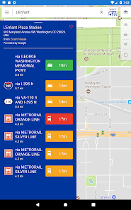
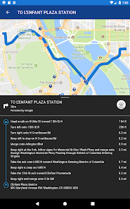
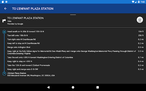
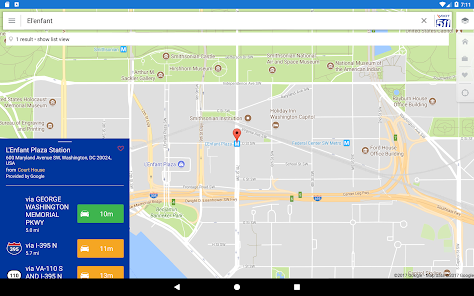
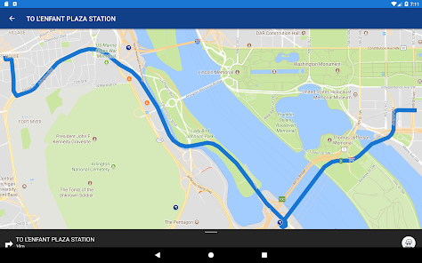
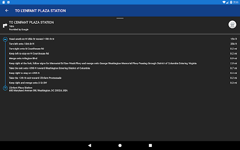
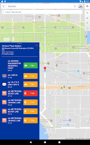
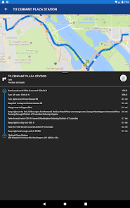
Open the app, search for any location in the search bar, and see travel times for driving and/or transit options to that location provided by Google. Tap on an option to see detailed driving or transit directions, then tap on the Waze button to open the Waze App for navigation to your destination (installation of Waze app is required to use this feature).
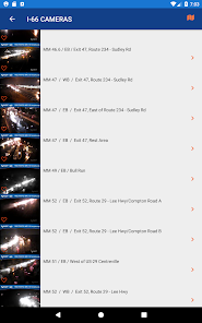
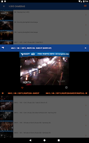
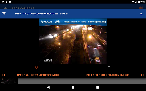
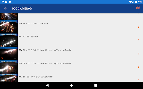
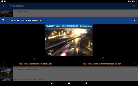
Access to VDOT cameras, incident reports, construction, bridge openings, and more is provided on the map by toggle option from the overlays menu in the upper right. Tap the pencil in this menu to re-order the Map Layers in the menu as you desire.
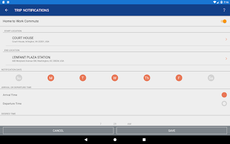
The main menu in the upper left provides access to Twitter feeds, cameras by route, travel times for predefined road segments, links to other commuter services for your area, and more. Settings can be accessed at the bottom of the main menu, and includes an option to sign up for trip notifications. Trip notifications allow you to define a recurring trip and desired arrival time, and receive a push notification in advance of the necessary departure time based upon the current traffic each day. Please note that traffic conditions can change rapidly, and travel and arrival times are a best estimate, but can never be a guarantee.
Additional information available in Northern Virginia includes VRE rail and PRTC bus schedules and routes, along with real-time VRE train locations. A unique feature provides a limited ability to see drive-to-transit options for these services when the “Nearby Transit Options” is selected from certain directions results. These services will be expanded in the future to include more agencies statewide. Other features in the app will also continue to be enhanced over time.
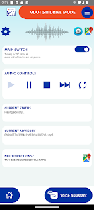
Utilize drive mode, to provide a customized radio-like traffic report as you drive! Hear pre-recorded media of all or a customizable subset of events near your location (and within a radius you can customize) as you go along your route. You can also limit events to those on your specific path of travel by setting a route in conjunction with Google Maps!
Powered by ClearRoute™
Open the app, search for any location in the search bar, and see travel times for driving and/or transit options to that location provided by Google. Tap on an option to see detailed driving or transit directions, then tap on the Waze button to open the Waze App for navigation to your destination (installation of Waze app is required to use this feature).
Access to VDOT cameras, incident reports, construction, bridge openings, and more is provided on the map by toggle option from the overlays menu in the upper right. Tap the pencil in this menu to re-order the Map Layers in the menu as you desire.
The main menu in the upper left provides access to Twitter feeds, cameras by route, travel times for predefined road segments, links to other commuter services for your area, and more. Settings can be accessed at the bottom of the main menu, and includes an option to sign up for trip notifications. Trip notifications allow you to define a recurring trip and desired arrival time, and receive a push notification in advance of the necessary departure time based upon the current traffic each day. Please note that traffic conditions can change rapidly, and travel and arrival times are a best estimate, but can never be a guarantee.
Additional information available in Northern Virginia includes VRE rail and PRTC bus schedules and routes, along with real-time VRE train locations. A unique feature provides a limited ability to see drive-to-transit options for these services when the “Nearby Transit Options” is selected from certain directions results. These services will be expanded in the future to include more agencies statewide. Other features in the app will also continue to be enhanced over time.
Utilize drive mode, to provide a customized radio-like traffic report as you drive! Hear pre-recorded media of all or a customizable subset of events near your location (and within a radius you can customize) as you go along your route. You can also limit events to those on your specific path of travel by setting a route in conjunction with Google Maps!
Powered by ClearRoute™
Date de mise à jour
La sécurité, c'est d'abord comprendre comment les développeurs collectent et partagent vos données. Les pratiques concernant leur confidentialité et leur protection peuvent varier selon votre utilisation, votre région et votre âge. Le développeur a fourni ces informations et peut les modifier ultérieurement.

Aucune donnée partagée avec des tiers
En savoir plus sur la manière dont les développeurs déclarent le partage

Cette appli peut recueillir ces types de données
Position, Activité dans l'application, Infos et performance des applis

Les données sont chiffrées lors de leur transfert

Impossible de supprimer les données
Notes et avis
4,1
827 avis
Nouveautés
Removed Twitter alerts.
Updated VDOT emergency alerts.
Updated VDOT emergency alerts.


