Natural Disaster Monitor
ବିଜ୍ଞାପନ ଅନ୍ତର୍ଭୂକ୍ତ
3.2star
315ଟି ସମୀକ୍ଷା
50ହ+
ଡାଉନଲୋଡ

ସମସ୍ତେ
info


ଏହି ଆପ୍ ବିଷୟରେ
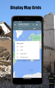
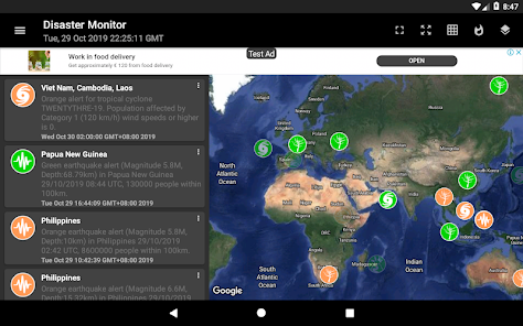
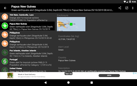
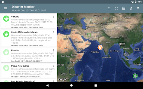
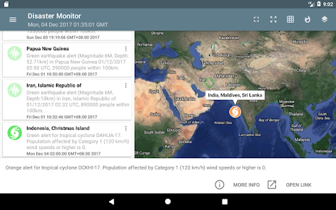
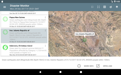
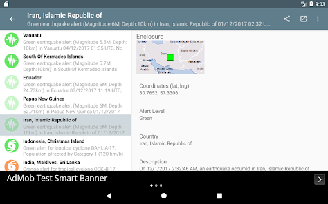
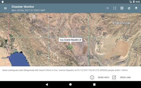
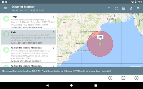
You can monitor natural disasters around the world, as published by the Global Disaster Alert and Coordination System - www.gdacs.org. The app shows the latest natural disasters like earthquakes, droughts, volcano eruptions, tropical cyclones, tsunamis and floods as color coded icons in a list as well as on a Google Maps backdrop; the icon colors indicate the alert level - green, orange, and red. The icon will look more transparent the older the event was published. Clicking on the item will bring up more details about the disaster event. UTM or geographic grids can optionally be displayed on the map.
* Now with dark mode setting.
* Now with dark mode setting.
ଗତ ଅପଡେଟର ସମୟ
ଡେଭେଲପରମାନେ ଆପଣଙ୍କ ଡାଟାକୁ କିପରି ସଂଗ୍ରହ ଏବଂ ସେୟାର କରନ୍ତି ସେହି ଧାରଣା ସହିତ ସୁରକ୍ଷା ଆରମ୍ଭ ହୁଏ। ଆପଣଙ୍କ ବ୍ୟବହାର, ଅଞ୍ଚଳ ଏବଂ ବୟସ ଆଧାରରେ, ଡାଟା ଗୋପନୀୟତା ଓ ସୁରକ୍ଷା ପ୍ରାକ୍ଟିସ ଭିନ୍ନ ହୋଇପାରେ। ଡେଭେଲପର ଏହି ସୂଚନା ପ୍ରଦାନ କରିଛନ୍ତି ଏବଂ ସେ ସମୟାନୁସାରେ ଏହାକୁ ଅପଡେଟ କରିପାରନ୍ତି।

ତୃତୀୟ ପକ୍ଷଗୁଡ଼ିକ ସହ କୌଣସି ଡାଟା ସେୟାର କରାଯାଇନାହିଁ
ଡେଭେଲପରମାନେ କିପରି ସେୟାରିଂର ଘୋଷଣା କରନ୍ତି ସେ ବିଷୟରେ ଅଧିକ ଜାଣନ୍ତୁ

କୌଣସି ଡାଟା ସଂଗ୍ରହ କରାଯାଇନାହିଁ
ଡେଭେଲପରମାନେ କିପରି ସଂଗ୍ରହର ଘୋଷଣା କରନ୍ତି ସେ ବିଷୟରେ ଅଧିକ ଜାଣନ୍ତୁ

ଟ୍ରାଞ୍ଜିଟ ସମୟରେ ଡାଟା ଏନକ୍ରିପ୍ଟ କରାଯାଇଥାଏ

ଡାଟା ଡିଲିଟ କରାଯାଇପାରିବ ନାହିଁ
ମୂଲ୍ୟାଙ୍କନ ଓ ସମୀକ୍ଷା
3.1
262ଟି ସମୀକ୍ଷା
ନୂଆ କଣ ଅଛି
Add null checks for bitmap conversion
ଆପ ସପୋର୍ଟ
ଡେଭେଲପରଙ୍କ ବିଷୟରେ
Dominic Chin Chi Yin
dominoc925@ymail.com
Singapore
undefined


