AR Bearing + Baseplate Compass
Përmban reklamaBlerje përmes aplikacionit
4,1star
567 komente
50 mijë+
shkarkime

Të gjithë
info


Rreth këtij aplikacioni
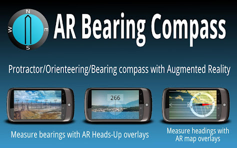
A free baseplate compass and a bearing compass with Augmented Reality (AR) in a single tool !
* Measure and record headings on paper or digital maps.
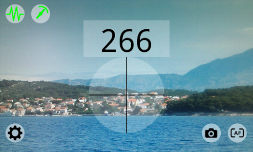
* Head towards the right direction using the Augmented Reality Heads-Up overlay.
* Take and record bearings in the field.
* Fast and stable.
!!! CAUTION
For best results:
* calibrate the magnetic sensors every time you use the application: move your device along a "8" shaped path several times
* some protective cases and pouches include a MAGNET. If this is your case, please keep the magnet away from your device when using the application.
Features of the free version:
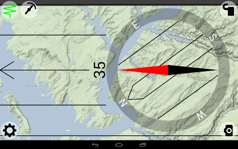
* Baseplate compass with rotating dial and precise heading display.
* Baseplate compass background can be set to camera preview or picture. Very useful if you have maps stored as pictures on your device.
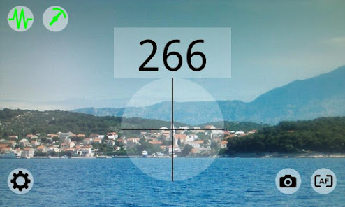
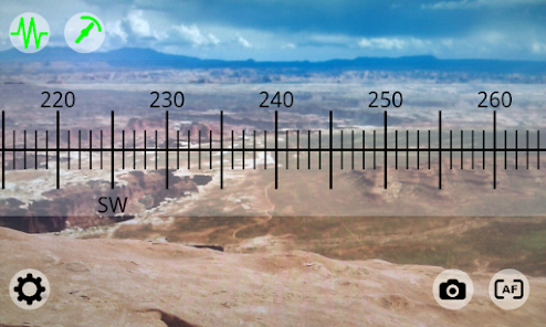
* Bearing compass with 2 Augmented Reality (AR) modes: ruler overlay and viewfinder overlay.
* 4 different overlay transparency levels.
* Sensor accuracy indication.
* Autofocus and macro focus (if supported by device camera).
* Zoom (if supported by device camera).
* Field of View automatic detection and calibration.
* Sensor update rate settings.
* Sensor filtering settings.
* Easy to use
* Detailed user guide
Paid Pro-version includes following extra features:
* Pitch (aka tilt) display.
* Augmented Reality (AR) screenshots to record headings and bearings in all modes.
* True/Geographic North indication (magnetic declination correction using a numerical model and GPS or network based geolocation).
* Manual location settings to get the magnetic declination without GPS nor network connection
* Augmented Reality (AR) screenshots geo-tagging (GPS or network based geolocation) and time.
* Bearing and pitch stored in EXIF.
* EXIF data overlaid on snapshot
* Augmented Reality (AR) screenshots resolution settings.
* Removal of ads and Goodbye screen.
Numerous applications including:
* Orienteering
* Sailing
* Hiking
* Trekking
* Backpacking
* Outdoor activities
* Topographic and site survey
!!!!!!!!! IMPORTANT !!!!!!!!
Sensors behavior can vary a lot between devices.
If AR Bearing Compass does not work properly on your device, please drop me an email indicating your device model and Android version and a description of the issue.
Thanks!
* Measure and record headings on paper or digital maps.
* Head towards the right direction using the Augmented Reality Heads-Up overlay.
* Take and record bearings in the field.
* Fast and stable.
!!! CAUTION
For best results:
* calibrate the magnetic sensors every time you use the application: move your device along a "8" shaped path several times
* some protective cases and pouches include a MAGNET. If this is your case, please keep the magnet away from your device when using the application.
Features of the free version:
* Baseplate compass with rotating dial and precise heading display.
* Baseplate compass background can be set to camera preview or picture. Very useful if you have maps stored as pictures on your device.
* Bearing compass with 2 Augmented Reality (AR) modes: ruler overlay and viewfinder overlay.
* 4 different overlay transparency levels.
* Sensor accuracy indication.
* Autofocus and macro focus (if supported by device camera).
* Zoom (if supported by device camera).
* Field of View automatic detection and calibration.
* Sensor update rate settings.
* Sensor filtering settings.
* Easy to use
* Detailed user guide
Paid Pro-version includes following extra features:
* Pitch (aka tilt) display.
* Augmented Reality (AR) screenshots to record headings and bearings in all modes.
* True/Geographic North indication (magnetic declination correction using a numerical model and GPS or network based geolocation).
* Manual location settings to get the magnetic declination without GPS nor network connection
* Augmented Reality (AR) screenshots geo-tagging (GPS or network based geolocation) and time.
* Bearing and pitch stored in EXIF.
* EXIF data overlaid on snapshot
* Augmented Reality (AR) screenshots resolution settings.
* Removal of ads and Goodbye screen.
Numerous applications including:
* Orienteering
* Sailing
* Hiking
* Trekking
* Backpacking
* Outdoor activities
* Topographic and site survey
!!!!!!!!! IMPORTANT !!!!!!!!
Sensors behavior can vary a lot between devices.
If AR Bearing Compass does not work properly on your device, please drop me an email indicating your device model and Android version and a description of the issue.
Thanks!
Përditësuar më
Siguria fillon me njohjen e mënyrës se si i mbledhin dhe i ndajnë zhvilluesit të dhënat e tua. Praktikat për privatësinë dhe sigurinë e të dhënave mund të variojnë bazuar në përdorimin, rajonin dhe moshën tënde. Këto informacione janë dhënë nga zhvilluesi dhe ato mund të përditësohen me kalimin e kohës.

Nuk ndahen të dhëna me palë të treta
Mëso më shumë për mënyrën se si e deklarojnë zhvilluesit ndarjen e të dhënave

Ky aplikacion mund të mbledhë këto lloje të dhënash
Informacionet e aplikacioneve dhe cilësia e funksionimit

Të dhënat janë enkriptuar gjatë transferimit

Të dhënat nuk mund të fshihen
Vlerësime dhe komente
4,1
535 komente
Ç'të reja ka
v1.14
Faster & more stable bearing indication
Ruler scaling changed in line with zoom level
v1.13
Fixed a display bug (pitch & roll in degrees/minutes) in some locales
Faster & more stable bearing indication
Ruler scaling changed in line with zoom level
v1.13
Fixed a display bug (pitch & roll in degrees/minutes) in some locales


