Earthquakes
Reklamalar mavjudIlova ichida xaridlar
4,2star
2,31 ming ta sharh
500 ming+
Yuklanmalar

Hamma uchun
info


Bu ilova haqida
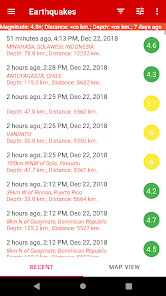
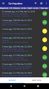
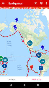
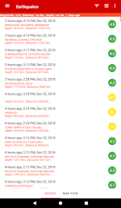
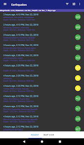
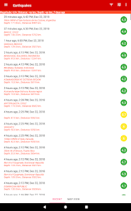
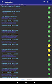
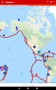
This mobile application is designed for users who are interested in staying informed about the latest earthquakes around the world. The app features a database of the latest earthquakes, which can be displayed in a list and on a map. The list view allows users to see the location, magnitude, and time of each earthquake, while the map view provides a visual representation of the earthquakes' locations.
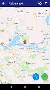
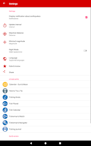
Users can filter the list of earthquakes based on strength, distance from their current location, and depth. This makes it easier for users to find earthquakes that are relevant to them, and to see how close earthquakes are to their current location.
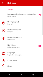
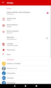
The app also includes an alert feature that notifies users about new earthquakes in real-time. This feature can be turned on or off, and users can choose to receive alerts for earthquakes of a certain magnitude or within a certain distance from their current location.
Whether you're a scientist, a geology enthusiast, or just someone who wants to stay informed about earthquakes, this app is for you.
In addition to the list and map views, this application also provides detailed information about each earthquake, including its depth, magnitude, and intensity. Users can also access a history of past earthquakes, which allows them to track the frequency and distribution of earthquakes over time.
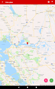
Another great feature of Earthquake Alert is its ability to display earthquakes on a map using satellite imagery. This provides users with a visual representation of the earthquakes' locations, and makes it easy to see the proximity of earthquakes to populated areas.
Also the map shows the boundaries of tectonic plates on which earthquakes occur, it is possible to assess the dangerous and safe countries and regions of the planet.
Data on earthquakes are taken from the official “USGS” program, “European seismic program” - “EMSC” and “New Zealand GeoNet service”.
Users can filter the list of earthquakes based on strength, distance from their current location, and depth. This makes it easier for users to find earthquakes that are relevant to them, and to see how close earthquakes are to their current location.
The app also includes an alert feature that notifies users about new earthquakes in real-time. This feature can be turned on or off, and users can choose to receive alerts for earthquakes of a certain magnitude or within a certain distance from their current location.
Whether you're a scientist, a geology enthusiast, or just someone who wants to stay informed about earthquakes, this app is for you.
In addition to the list and map views, this application also provides detailed information about each earthquake, including its depth, magnitude, and intensity. Users can also access a history of past earthquakes, which allows them to track the frequency and distribution of earthquakes over time.
Another great feature of Earthquake Alert is its ability to display earthquakes on a map using satellite imagery. This provides users with a visual representation of the earthquakes' locations, and makes it easy to see the proximity of earthquakes to populated areas.
Also the map shows the boundaries of tectonic plates on which earthquakes occur, it is possible to assess the dangerous and safe countries and regions of the planet.
Data on earthquakes are taken from the official “USGS” program, “European seismic program” - “EMSC” and “New Zealand GeoNet service”.
Oxirgi yangilanish
Xavfsizlik — dastur ishlab chiquvchilar maʼlumotlaringizni qanday jamlashi va ulashishini tushinishdan boshlanadi. Maʼlumotlar maxfiyligi va xavfsizlik amaliyotlari ilovadan foydalanish, hudud va yoshga qarab farq qilishi mumkin. Bu axborot dastur ishlab chiquvchi tomonidan taqdim etilgan va keyinchalik yangilanishi mumkin.


Reytinglar va sharhlar
4,2
2,24 ming ta sharh

Marjona Toxirova
- Nomaqbul deb belgilash
- Sharh tarixini ochish
22-aprel, 2024
Qanday yoqishni tushunib bulmadi

Xolmurod Suratjonov
- Nomaqbul deb belgilash
22-yanvar, 2024
Ok

Laylo Rahimova
- Nomaqbul deb belgilash
23-mart, 2023
Uncha chunmadim qande oldindan xabar beredigonini yoqib quysa bo'ladi kecha yer qimirlaganda xish tima xabar bermadi?
10 kishi bu sharhni foydali deb topgan
Nima yangiliklar
- fix location search
- add location history
- add location history


