TrekMe - GPS trekking offline
Ilova ichida xaridlar
3,9star
718 ta sharh
100 ming+
Yuklanmalar

Hamma uchun
info

Bu ilova haqida
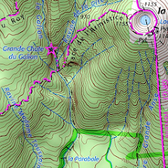
TrekMe is an Android app to get live position on a map and other useful information, without ever needing an internet connection (except when creating a map). It's ideal for trekking, biking, or any outdoor activity.
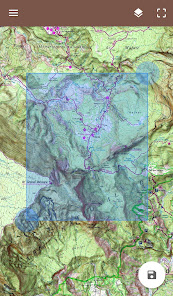
In this application, you create a map by chosing the area you want to download. Then, your map is available for offline usage (the GPS works even without mobile data).
Download from USGS, OpenStreetMap, SwissTopo, IGN (France and Spain)
Other topographic map sources will be added.
Fluid and doesn't drain the battery
Particular attention was given to efficency, low battery usage, and smooth experience.
SD card compatible
A large map can be quite heavy and may not fit into your internal memory. If you have an SD card, you can use it.
Features
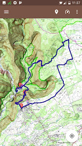
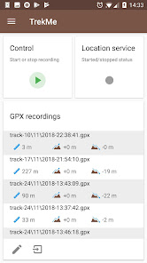
• Import, record, and share GPX files
• Marker support, with optional comments
• Real-time visualization of a GPX record, as well as its statistics (distance, elevation, ..)
• Orientation, distance, and speed indicators
• Measure a distance along a track
• Be alerted when you move away from a track
For instance, all map providers are free, except for France IGN - which requires an annual subscription.
For professionals and enthousiasts
If you have an external GPS with bluetooth*, you can connect it to TrekMe and use it instead of the internal GPS of your device. This is especially useful when your activity (aeronautic, professional topography, ..) requires better precision and updating your position at a higher frequency than every second.
(*) Supports NMEA over bluetooth
Privacy
During a GPX recording, the app collects location data even when the app is closed or not in use. However, your location will never be shared with anyone and gpx files are stored locally on your device.
General TrekMe guide
https://github.com/peterLaurence/TrekMe/blob/master/Readme.md
In this application, you create a map by chosing the area you want to download. Then, your map is available for offline usage (the GPS works even without mobile data).
Download from USGS, OpenStreetMap, SwissTopo, IGN (France and Spain)
Other topographic map sources will be added.
Fluid and doesn't drain the battery
Particular attention was given to efficency, low battery usage, and smooth experience.
SD card compatible
A large map can be quite heavy and may not fit into your internal memory. If you have an SD card, you can use it.
Features
• Import, record, and share GPX files
• Marker support, with optional comments
• Real-time visualization of a GPX record, as well as its statistics (distance, elevation, ..)
• Orientation, distance, and speed indicators
• Measure a distance along a track
• Be alerted when you move away from a track
For instance, all map providers are free, except for France IGN - which requires an annual subscription.
For professionals and enthousiasts
If you have an external GPS with bluetooth*, you can connect it to TrekMe and use it instead of the internal GPS of your device. This is especially useful when your activity (aeronautic, professional topography, ..) requires better precision and updating your position at a higher frequency than every second.
(*) Supports NMEA over bluetooth
Privacy
During a GPX recording, the app collects location data even when the app is closed or not in use. However, your location will never be shared with anyone and gpx files are stored locally on your device.
General TrekMe guide
https://github.com/peterLaurence/TrekMe/blob/master/Readme.md
Oxirgi yangilanish
Xavfsizlik — dastur ishlab chiquvchilar maʼlumotlaringizni qanday jamlashi va ulashishini tushinishdan boshlanadi. Maʼlumotlar maxfiyligi va xavfsizlik amaliyotlari ilovadan foydalanish, hudud va yoshga qarab farq qilishi mumkin. Bu axborot dastur ishlab chiquvchi tomonidan taqdim etilgan va keyinchalik yangilanishi mumkin.


Reytinglar va sharhlar
3,8
692 ta sharh

Bekzod Mahmadmurodov
- Nomaqbul deb belgilash
17-yanvar, 2024
Zoʼr ekan.
1 kishi bu sharhni foydali deb topgan
Nima yangiliklar
4.3.0
• New optional track export format: GeoJSON
• Simplified settings
4.2.3
• Stability improvements
• NEW: Search for markers, multi select them for color change or deletion…
• New optional track export format: GeoJSON
• Simplified settings
4.2.3
• Stability improvements
• NEW: Search for markers, multi select them for color change or deletion…


