
Aloft Air Aware
3.9star
66 reviews
10K+
Downloads

Everyone
info


About this app
Airspace safety and situational awareness is no longer just about "before" you fly but across the entirety of your operation.
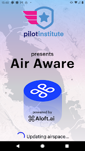
From the makers of the original B4UFLY, Aloft is launching Air Aware for next-generation situational awareness. In partnership with Pilot Institute (https://pilotinstitute.com), Air Aware is the platform for all drone pilots to get started safely and compliantly to fly drones.
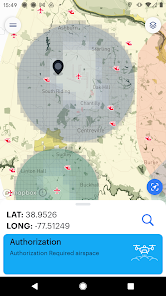
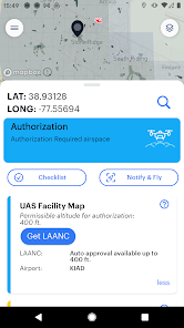
In addition to authoritative airspace information from Aloft (an FAA-approved UAS Service Supplier for LAANC), Air Aware includes Aloft's exclusive Geo layers with over 10 million square miles of local, state, and federal advisory information to assist pilots with takeoff/landing restrictions and other pertinent safety information.
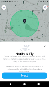
We've also incorporated Aloft's Notify & Fly system, originally introduced in the FAA's B4UFLY app, into Air Aware -- giving pilots the ability to read and share live flight volumes for complete real-time situational awareness and deconfliction.
As we've partnered with Pilot Institute, inside Air Aware you will also find links to free resources, such as training videos, FAA TRUST information, and free stickers for labeling your drone.
Please get in touch with our team directly at support@aloft.ai if you have any questions, feedback, or ideas. Together with Pilot Institute, we're looking for your feedback as we evolve this new platform.
From the makers of the original B4UFLY, Aloft is launching Air Aware for next-generation situational awareness. In partnership with Pilot Institute (https://pilotinstitute.com), Air Aware is the platform for all drone pilots to get started safely and compliantly to fly drones.
In addition to authoritative airspace information from Aloft (an FAA-approved UAS Service Supplier for LAANC), Air Aware includes Aloft's exclusive Geo layers with over 10 million square miles of local, state, and federal advisory information to assist pilots with takeoff/landing restrictions and other pertinent safety information.
We've also incorporated Aloft's Notify & Fly system, originally introduced in the FAA's B4UFLY app, into Air Aware -- giving pilots the ability to read and share live flight volumes for complete real-time situational awareness and deconfliction.
As we've partnered with Pilot Institute, inside Air Aware you will also find links to free resources, such as training videos, FAA TRUST information, and free stickers for labeling your drone.
Please get in touch with our team directly at support@aloft.ai if you have any questions, feedback, or ideas. Together with Pilot Institute, we're looking for your feedback as we evolve this new platform.
Updated on
Safety starts with understanding how developers collect and share your data. Data privacy and security practices may vary based on your use, region, and age. The developer provided this information and may update it over time.

No data shared with third parties
Learn more about how developers declare sharing

This app may collect these data types
App activity and App info and performance

Data is encrypted in transit

Data can’t be deleted
Ratings and reviews
3.8
64 reviews

Michael Wells
- Flag inappropriate
- Show review history
February 2, 2024
Does the job of helping determine if you're in a generally clear spot to fly. Would love to see: (1) a button that can reorient your map straight North if you've accidentally turned it; (2) easy way to see NOTAMs, TFRs, and local weather conditions for the closest airport with automated weather data (AWOS etc). Note to Aloft - these reviews ARE the feedback; please don't ask to send an email. You have the suggestions right here.
8 people found this review helpful
Aloft (www.aloft.ai)
February 4, 2024
Point taken, Michael. We always welcome a deeper dialog if you want it, but trust us -- we take all these reviews into consideration for our roadmap, as well as the Pilot Institute survey, etc, etc. NOTAMS and TFRs are already in the airspace map and advisories. Weather and LAANC is on the way :)

Rene R
- Flag inappropriate
- Show review history
December 17, 2023
Honestly, I don't know why it's so difficult for companies to work on their UI. B4UFly and now this app have UI problems where it would be simple to fix. As a novice app developer, I could fix it for you. Also the entire hamburger menu is useless and a waste of space. All are external links and when you go back to the app, the app has to reload (instead of updating in the background) . Just kinda clumsy. The one link that is actually needed "Get LAANC" IS COVERED by your "Leave us a review"
19 people found this review helpful
Aloft (www.aloft.ai)
December 18, 2023
Hi, Rene. We'd love to dive into these. Can you send us a screenshot of what overlap you're seeing? Please reach out to support@aloft.ai if you have any other questions, feedback, etc. We'd love to hear from you.

Howard Quimby
- Flag inappropriate
- Show review history
February 26, 2024
Uninstalled. I was hoping this was a feature complete successor to Air Control including ceiling heights, LAANC approvals, weather forecasts and flight logs like Airdata UAV. The Pilot Institute partnership is all this app adds right now. Even the main menu is too large to display correctly on mobile. Aloft still needs the Air Control app to view ground/parks details and LAANC approvals. Airdata UAV still wins for weather, logs, analysis and clear pricing. I use OpenSky for easier LAANC.
4 people found this review helpful
Aloft (www.aloft.ai)
February 24, 2024
Thanks, Howard. Appreciate the feedback. If you've been following the Aloft + Pilot Institute news around Air Aware, you'll see that we're on the track to this app for you! Stay tuned and reach out any time. We love hearing from the Aloft community!
What's new
This update adds new data layers, including all FAA-required B4UFLY layers for Military Training Routes, Part 93, and Recreational Flyer Fixed Sites. We’ve also added an all-new data layer for FRIAs (FAA Recognized Identification Areas) where Remote ID is not required.
We’ve made other performance and speed improvements that y’all have requested, including faster load times.
We’ve made other performance and speed improvements that y’all have requested, including faster load times.


