
MNsight - Lidar and what's bel
4.9star
28 reviews
5K+
Downloads

Everyone
info

About this app
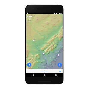
Explore the beautiful detail of Minnesota's statewide Lidar topographic dataset, and find out what lies beneath your feet - anywhere in the state.
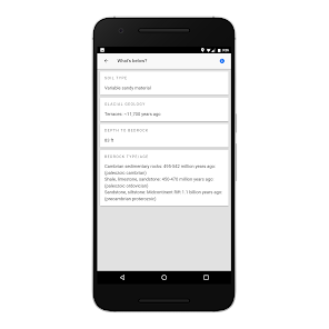
Tap anywhere on the map within Minnesota to get information about the soil, glacial geology, depth of the bedrock below the land's surface, and the types and ages of the bedrock in that location. Press the 'below me now' button to instantly get the above information about your current GPS determined location.
Tap anywhere on the map within Minnesota to get information about the soil, glacial geology, depth of the bedrock below the land's surface, and the types and ages of the bedrock in that location. Press the 'below me now' button to instantly get the above information about your current GPS determined location.
Updated on
Data safety
Developers can show information here about how their app collects and uses your data. Learn more about data safety

No information available
Ratings and reviews
4.8
27 reviews

A Google user
- Flag inappropriate
July 18, 2019
This map is going no where apart from manisota,
4 people found this review helpful
Regents of the University of Minnesota
August 28, 2019
The app is made for use in Minnesota, sorry you thought otherwise.
A Google user
- Flag inappropriate
- Show review history
March 13, 2018
Another great app from Shane Loeffler! A great way for professionals and non-professionals alike to quickly access geologic information. Simple, useful, clean and fast.
11 people found this review helpful
A Google user
- Flag inappropriate
- Show review history
March 12, 2018
I love this app. It is extremely well optimized and the idea is unique and well executed. I'm always happy to support projects like these!
6 people found this review helpful
What's new
Geology queries fixed!


