Altimeter Plus & GPS Altitude
Enthält WerbungIn-App-Käufe
2.7star
232 Rezensionen
100 Tsg.+
Downloads

Jedes Alter
info


Über diese App
Altimeter GPS app is an accurate Altitude meter App used to measure elevation above sea level. Elevation Altimeter map is an elevation tracker app that uses Altitude GPS online and offline Map. You can also find Satellite based altitude elevation using this barometric pressure app. The new Altimeter GPS is an elevation tracker used to measure GPS altitude above sea level with the help of an elevation app. The Altimeter Free app is a smart altitude tool that measures my elevation and GPS location. It is a perfect altitude tracking app for people who love Mountain biking, Hiking, or visiting Hiking areas. Aircraft pilots also use this Altitude measure App to measure the aircraft altitude. This App is used for my GPS coordinates, Latitude, longitude, and altitude measuring. Here are the other valuable features of this altimeter measuring and barometric pressure App.
Altimeter Offline Install GPS altimeter to get accurate longitude and latitude along with live location
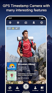
Altimeter App-Compass Get digital compass with weather alerts for android and camera stamp date & time
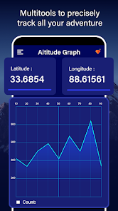
Save History of Altitude using altimeter app
Your altitude elevation changes at a high altitude above sea level. To measure and record these elevations, you can take pictures of yourself and save these altitude heights. You can see all of these altimeter elevation images in the altimeter widget. Take a photo at different air pressures using this altimeter barometric pressure app and save all the elevation records in a map chart. You can check my altitude, elevation from above sea level or Localization coordinates any time with high precision of altitude. It works online and offline and also Saves Altitude History with charts.
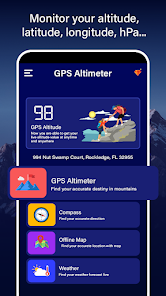
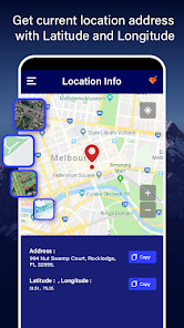
GPS Coordinates with Elevation Accurate location with GPS navigation of live location and check height above sea level
Magnetic Compass App Get GPS camera photo with location with longitude and latitude with accurate GPS location
Different map modes with Localization coordinates:
Calculating my altitude to varying elevations in localization coordinates is easy in longitude and latitude coordinates. There are various GPS maps with localization coordinates of Latitude and longitude. These Gps Maps are online and offline GPS maps. This accurate altimeter app will help you measure pressure by connecting it with a GPS map of Latitude and longitude.
Pressure measurement using barometer:
The barometer measures atmospheric air pressure at different levels above sea level. The barometer only works when your device has a barometer sensor to measure pressure. Therefore, you can find air pressure using this barometer at different altitudes.
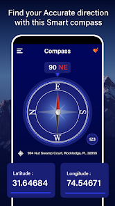
Digital Compass with altimeter map:
You can also find the correct direction using Digital Compass in this Altimeter digital compass app. Also, with these features, you will find guidance with longitude and Latitude. Digital Compass is the most accurate smart compass app for outdoor activities like hilly areas and airplanes.
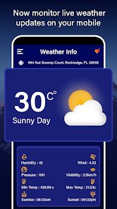
Weather forecast:
Enjoy the weather app with an accurate weather forecast, weather widget, and local radar map. It's not a problem where you are; the weather app will provide accurate and detailed live weather forecast information. Find the actual time and accurate weather forecast information with Air pressure and rain details. You will find detailed information about the weather in hours and days. Measure accurate altitude above sea level & elevation with a GPS altimeter app.
Compass to find direction Check altitude by capturing images to get GPS camera photo with location GPS coordinates
GPS Altimeter Suitable for hiking and trekking mountains to check height above sea level altitude
GPS Altimeter Compass View your height above sea level, get weather alerts and GPS compass live navigation
True North Compass Maps with longitude and latitude, GPS live satellite location, navigate digital compass.
Altimeter Offline Install GPS altimeter to get accurate longitude and latitude along with live location
Altimeter App-Compass Get digital compass with weather alerts for android and camera stamp date & time
Save History of Altitude using altimeter app
Your altitude elevation changes at a high altitude above sea level. To measure and record these elevations, you can take pictures of yourself and save these altitude heights. You can see all of these altimeter elevation images in the altimeter widget. Take a photo at different air pressures using this altimeter barometric pressure app and save all the elevation records in a map chart. You can check my altitude, elevation from above sea level or Localization coordinates any time with high precision of altitude. It works online and offline and also Saves Altitude History with charts.
GPS Coordinates with Elevation Accurate location with GPS navigation of live location and check height above sea level
Magnetic Compass App Get GPS camera photo with location with longitude and latitude with accurate GPS location
Different map modes with Localization coordinates:
Calculating my altitude to varying elevations in localization coordinates is easy in longitude and latitude coordinates. There are various GPS maps with localization coordinates of Latitude and longitude. These Gps Maps are online and offline GPS maps. This accurate altimeter app will help you measure pressure by connecting it with a GPS map of Latitude and longitude.
Pressure measurement using barometer:
The barometer measures atmospheric air pressure at different levels above sea level. The barometer only works when your device has a barometer sensor to measure pressure. Therefore, you can find air pressure using this barometer at different altitudes.
Digital Compass with altimeter map:
You can also find the correct direction using Digital Compass in this Altimeter digital compass app. Also, with these features, you will find guidance with longitude and Latitude. Digital Compass is the most accurate smart compass app for outdoor activities like hilly areas and airplanes.
Weather forecast:
Enjoy the weather app with an accurate weather forecast, weather widget, and local radar map. It's not a problem where you are; the weather app will provide accurate and detailed live weather forecast information. Find the actual time and accurate weather forecast information with Air pressure and rain details. You will find detailed information about the weather in hours and days. Measure accurate altitude above sea level & elevation with a GPS altimeter app.
Compass to find direction Check altitude by capturing images to get GPS camera photo with location GPS coordinates
GPS Altimeter Suitable for hiking and trekking mountains to check height above sea level altitude
GPS Altimeter Compass View your height above sea level, get weather alerts and GPS compass live navigation
True North Compass Maps with longitude and latitude, GPS live satellite location, navigate digital compass.
Aktualisiert am
Was die Sicherheit angeht, solltest du nachvollziehen, wie Entwickler deine Daten erheben und weitergeben. Die Datenschutz- und Sicherheitspraktiken können je nach Verwendung, Region und Alter des Nutzers variieren. Diese Informationen wurden vom Entwickler zur Verfügung gestellt und können jederzeit von ihm geändert werden.

Keine Daten werden mit Drittunternehmen oder -organisationen geteilt

Diese App kann die folgenden Datentypen erheben
Standort, Fotos und Videos und Geräte- oder andere IDs

Daten werden nicht verschlüsselt
Daten können nicht gelöscht werden
Bewertungen und Rezensionen
2.8
227 Rezensionen


