
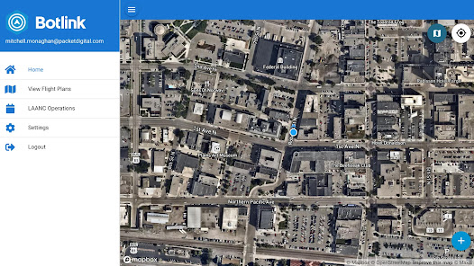
Botlink Capture Drone App

3,9star
23 recenzije
1 hilj.+
Preuzimanja

Svako
info


O aplikaciji
Capture the world with your DJI drone using the world’s easiest-to-use waypoint and survey mapping app. The free Botlink app features intuitive mission planning, automated flight, and automated image/data capture. Fewer buttons to push, a more intuitive process, and the most user-friendly experience means you’ll spend less time learning complex systems and more time getting work done. The Botlink app is designed to work seamlessly on a phone or tablet with no sacrifice of features, information, or usability.
Currently compatible with the latest DJI drones:
- Phantom 3 Pro
- Phantom 4
- Phantom 4 Pro
-Phantom 4 Pro V2.0
- Inspire 1 V2
- Inspire 1 Pro
- DJI Spark
- Mavic Pro
- Mavic Air
- Mavic 2 Pro
Supports Android 5+
Features & Benefits:
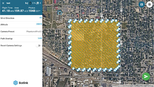
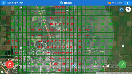
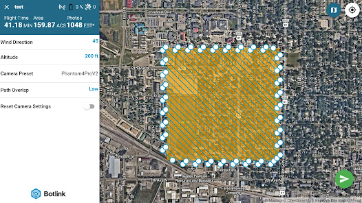
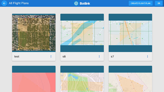
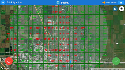
- Simple flight planning that enables you to track sites over time
- Location-aware flight plans
- Drag-and-drop waypoints
- Altitude settings
- No drone profiles necessary. Softwar recognizes drone camera, and adjust flight parameters, including speed, to capture ideal flight data
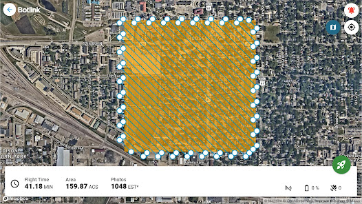
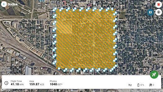
- Takeoff, landing, and everything in between is 100% automated
- Ability to land, swap batteries, and resume without losing flight progress
- Safety controls
- 3D modeling and map creation
- Track flight progress and monitor your drone from the ground
- Fully automated cameras, sensors, and live video
- Automatically capture still photos or stream live video
- In-app support
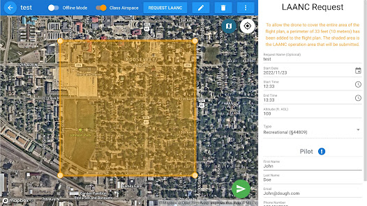
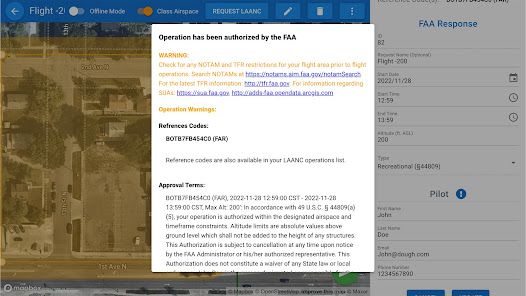
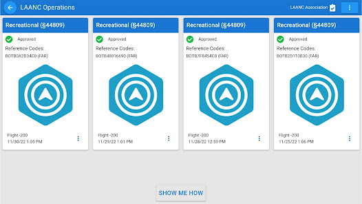
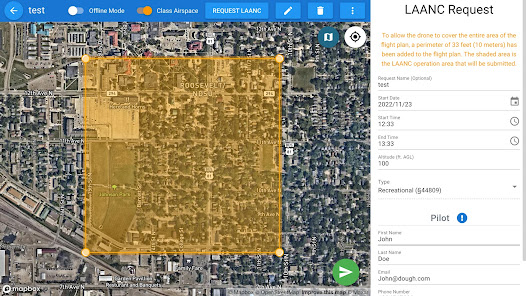
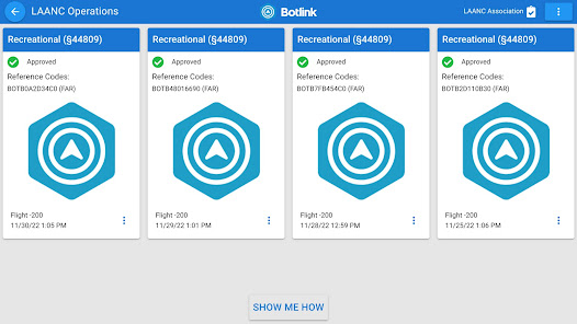
- LAANC Authorization requests and approval
Post-flight processing & analysis using Botlink:
- Upload drone imagery to our cloud-based software to automatically stitch aerial imagery and sensor data into high-resolution orthomosaic images
- Examine valuable maps such as orthomosaic, vegetation index, terrain maps, and 3D models
- Measure distance, area, and volume right from your computer or tablet
- Collaborate and share maps, annotations, and messages with colleagues
- Export data in the format you prefer and connect to industry software to streamline your workflow
- 14-day free trial of Botlink Professional at https://app.botlink.com/signup
Disclaimer:
The FAA requires that operators of unmanned aircraft follow specific aircraft registration and flight regulations. Please familiarize yourself with these rules and always operate your drone safely and responsibly. For more information on regulations in the United States, visit: https://www.faa.gov/uas/
Please note that safety features other than automated aircraft control and basic map functions may be limited outside of the United States.
Currently compatible with the latest DJI drones:
- Phantom 3 Pro
- Phantom 4
- Phantom 4 Pro
-Phantom 4 Pro V2.0
- Inspire 1 V2
- Inspire 1 Pro
- DJI Spark
- Mavic Pro
- Mavic Air
- Mavic 2 Pro
Supports Android 5+
Features & Benefits:
- Simple flight planning that enables you to track sites over time
- Location-aware flight plans
- Drag-and-drop waypoints
- Altitude settings
- No drone profiles necessary. Softwar recognizes drone camera, and adjust flight parameters, including speed, to capture ideal flight data
- Takeoff, landing, and everything in between is 100% automated
- Ability to land, swap batteries, and resume without losing flight progress
- Safety controls
- 3D modeling and map creation
- Track flight progress and monitor your drone from the ground
- Fully automated cameras, sensors, and live video
- Automatically capture still photos or stream live video
- In-app support
- LAANC Authorization requests and approval
Post-flight processing & analysis using Botlink:
- Upload drone imagery to our cloud-based software to automatically stitch aerial imagery and sensor data into high-resolution orthomosaic images
- Examine valuable maps such as orthomosaic, vegetation index, terrain maps, and 3D models
- Measure distance, area, and volume right from your computer or tablet
- Collaborate and share maps, annotations, and messages with colleagues
- Export data in the format you prefer and connect to industry software to streamline your workflow
- 14-day free trial of Botlink Professional at https://app.botlink.com/signup
Disclaimer:
The FAA requires that operators of unmanned aircraft follow specific aircraft registration and flight regulations. Please familiarize yourself with these rules and always operate your drone safely and responsibly. For more information on regulations in the United States, visit: https://www.faa.gov/uas/
Please note that safety features other than automated aircraft control and basic map functions may be limited outside of the United States.
Ažurirano dana
Sigurnost počinje razumijevanjem na koji način programeri prikupljaju i dijele vaše podatke. Privatnost podataka i sigurnosne prakse se mogu razlikovati ovisno o korištenju, regiji i dobi. Programer je pružio ove informacije i može ih s vremenom ažurirati.


Ocjene i recenzije
3,9
22 recenzije
Šta ima novo
Fixed issue with date validation during laanc form entry.


