Bristol Maps
In-app purchases
100+
Downloads

Everyone
info


About this app
Bristol Maps is designed specifically for commercial fishermen to navigate using the latest satellite imagery. Currently serving Bristol Bay and Copper River watersheds. Say goodbye to outdated maps and inaccurate information - our app utilizes the latest, detailed images for increased efficiency, safer fishing trips, and a higher return on investment.
Like all fishermen I have always relied on NOAA charts created for Bristol Bay. Given how fast the environment changes these are out of date almost as soon as they are made. In some areas there are no similarities between the NOAA charts and what exists. And as exciting as it is to find the channel with the bow of your boat it is at best time consuming and at worst dangerous in the wrong weather.
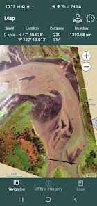
With this app you can view personally curated satellite images photographed at low tide. I've found its been helpful to see where bars have moved to. The core functionality allows for multiple images to be layered with transparencies to view simultaneously. For areas with multiple images at varying tides it allows you to see where there will/not be water available. NOAA charts are also available that allow new satellite imagery to be overlayed onto traditional familiar NOAA charts.
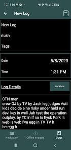
Beyond the core mapping functionality, tide and weather data is also available. Weather can be pinpointed to a location as well as the nearest NOAA zone weather forecast. These can be combined with the mapping functionality to create digital logs. Location, weather, and tide, catch/delivery data can all be integrated into a log event. Log events can be overlaid on the navigation page as well as analyzed to view catch data by species, area, gear type (4.75" vs 5"), and weather.
Feature list:
Satellite overlays available for: Naknek/Kvichak, Egegik, Ugashik, Nushagak, and Copper River. Additional areas added by request.
NOAA overlays available for Alaska while offline and all of US via online base map
Grid Layouts with search can replace traditional paper maps or code tables shared by groups. IE: "I'm over by green 22." A search tool is included to quickly find locations.
NOAA tide charts available offline for Bristol Bay tide stations. Other locations downloaded as they are used.
Pinpoint weather forecasts available as well as NOAA zone weather forecasts.
Boundary lines for all major districts are preprogrammed w/ the ability to create new boundaries. Use at your own risk.
A boundary alarm triggered when you are detected within X distance of the nearest boundary line.
Create Waypoints and Routes. These can also be exported/imported by other users to share data.
Online maps can also be streamed with NOAA charts, custom satellite views, a high res Ak Government view, and a street view if thats ever helpful.
Log events can record, opener times, tides, weather, pictures, sets/deliveries and district.
Coming this fall a printed log book will be available for a hard copy option to have a 'seasonal' journal.
Subscription required:
$150 billed annually
A two week free trial is included for testing and includes free cancellation. Subscription includes updates, bug fixes, general support and continuous imagery additions as available. All that for less than a Netflix subscription.
Like all fishermen I have always relied on NOAA charts created for Bristol Bay. Given how fast the environment changes these are out of date almost as soon as they are made. In some areas there are no similarities between the NOAA charts and what exists. And as exciting as it is to find the channel with the bow of your boat it is at best time consuming and at worst dangerous in the wrong weather.
With this app you can view personally curated satellite images photographed at low tide. I've found its been helpful to see where bars have moved to. The core functionality allows for multiple images to be layered with transparencies to view simultaneously. For areas with multiple images at varying tides it allows you to see where there will/not be water available. NOAA charts are also available that allow new satellite imagery to be overlayed onto traditional familiar NOAA charts.
Beyond the core mapping functionality, tide and weather data is also available. Weather can be pinpointed to a location as well as the nearest NOAA zone weather forecast. These can be combined with the mapping functionality to create digital logs. Location, weather, and tide, catch/delivery data can all be integrated into a log event. Log events can be overlaid on the navigation page as well as analyzed to view catch data by species, area, gear type (4.75" vs 5"), and weather.
Feature list:
Satellite overlays available for: Naknek/Kvichak, Egegik, Ugashik, Nushagak, and Copper River. Additional areas added by request.
NOAA overlays available for Alaska while offline and all of US via online base map
Grid Layouts with search can replace traditional paper maps or code tables shared by groups. IE: "I'm over by green 22." A search tool is included to quickly find locations.
NOAA tide charts available offline for Bristol Bay tide stations. Other locations downloaded as they are used.
Pinpoint weather forecasts available as well as NOAA zone weather forecasts.
Boundary lines for all major districts are preprogrammed w/ the ability to create new boundaries. Use at your own risk.
A boundary alarm triggered when you are detected within X distance of the nearest boundary line.
Create Waypoints and Routes. These can also be exported/imported by other users to share data.
Online maps can also be streamed with NOAA charts, custom satellite views, a high res Ak Government view, and a street view if thats ever helpful.
Log events can record, opener times, tides, weather, pictures, sets/deliveries and district.
Coming this fall a printed log book will be available for a hard copy option to have a 'seasonal' journal.
Subscription required:
$150 billed annually
A two week free trial is included for testing and includes free cancellation. Subscription includes updates, bug fixes, general support and continuous imagery additions as available. All that for less than a Netflix subscription.
Updated on
Safety starts with understanding how developers collect and share your data. Data privacy and security practices may vary based on your use, region, and age. The developer provided this information and may update it over time.

No data shared with third parties
Learn more about how developers declare sharing

No data collected
Learn more about how developers declare collection
What's new
New map configuration recommendations for PWS/Copper river flats
Bug fixes
Bug fixes


