Aqua Map Boating
In-app purchases
3.6star
673 reviews
100K+
Downloads

Everyone
info
About this app
FREE 14-day trial on ALL subscriptions.
Get the latest charts you can use offline, weather, tides and ActiveCaptain Points of Interest. Connect AIS and your boat instruments data via WiFi. Plan routes, record your tracks, follow your friends and share your data across devices or the community with Live Sharing.
THE MOST ADVANCED MARINE NAVIGATION APP
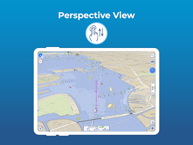
• Optimised for both smartphone and tablet
• Latest vector and raster nautical charts for offline use, updated regularly
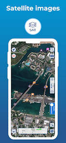
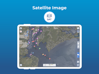
• Satellite imagery
• Routes/Tracks navigation with real-time information on bridges, hazards, and best fuel prices
• Easy manual route planning
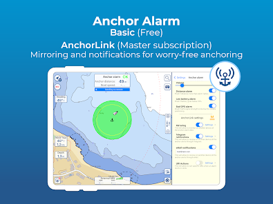
• Basic anchor alarm and advanced AnchorLink with mirroring and email/telegram notifications
• Marine Forecasts for wind, waves, currents and worldwide weather information
• Easy sharing and uploading of tracks, markers and routes
• Live Sharing-Aqua Map community to find new friends on the water
• ActiveCaptain and Waterway Guide community integration
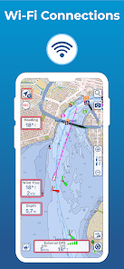
• Real time display of NMEA instruments (depth sounder, wind sensor, compass, GPS)
• AIS target display with automatic collision detection
• Powerful search with advanced settings
• Light/Dark display
• Optimised battery usage
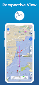
► NAUTICAL CHARTS
Aqua Map uses only official vector and raster Nautical charts complete with depth contours, navigation markers, buoys, lights and other chart features.You can download the maps at home on all your devices and use them on the boat offline (no internet connection required).
► ROUTES, WAYPOINTS AND TRACKS
Plan your route, insert and edit waypoints. Navigate your route and record your track, monitor distance, time (ETA), course and heading to next waypoint or your final destination.
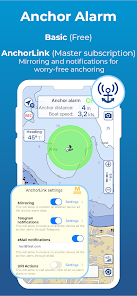
► ANCHOR ALARM
Advanced setup to let you set your anchor position and drift radius. Monitors in real time your GPS position against the defined drift area. An acoustic alarm will sound and a visual alarm be displayed when your GPS position is outside the defined range. There’s also a low battery alarm and a bad GPS reception alarm.
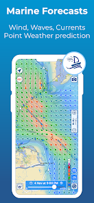
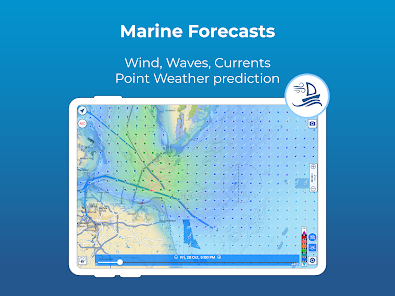
► TIDES AND MARINE FORECASTS
Get currents, wind and waves forecasts as overlay onto the chart with a time slider.
► LOADING and SHARING
Share your favorite markers on Facebook or send an email with your last daily track. Load KML, KMZ, GPX (including zip files).
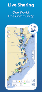
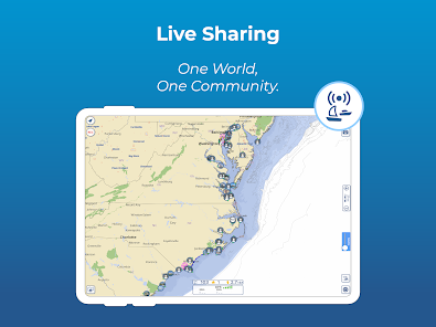
► LIVE SHARING
Share your data with the Aqua Map community, follow your friends and see all active users around you. Chat, send and receive routes/tracks/markers.
► ACTIVECAPTAIN and WATERWAY GUIDE
Access tens of thousands of points of interests and reviews across UK, Ireland and all over the world. Join the community of boaters who write reviews, update data and provide up to date hazard information.
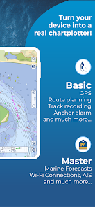
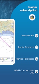
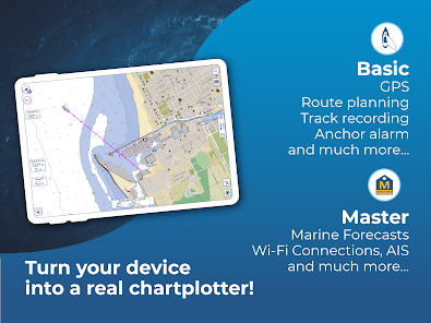
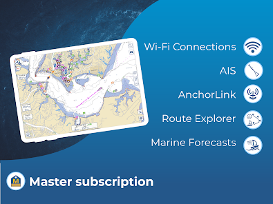
► AQUA MAP MASTER
Transform your device into a chartplotter with Aqua Map Master:
• AnchorLink with mirroring and email/telegram notifications
• Full marine forecasts (wind, waves, currents and weather).
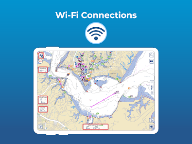
• Connect NMEA devices through WiFi and use instrument and AIS data all across the app.
• Display AIS targets on the chart with automatic collision detection.
• Make route planning easier with Route Explorer automatically finding anchorages, bridges and marinas close to your route.
► TYPE OF PURCHASES
Subscription: one year auto-renewable subscription. The payment will be made through your Google account. The subscription will renew automatically unless cancelled at least 24 hours before the expiration. The user can manage their subscription and turn off auto-renewal in the Google Account Settings section after purchase.
Terms of Service: https://www.aquamap.app/terms-and-conditions
Privacy Policy: https://www.aquamap.app/privacy-policy
Get the latest charts you can use offline, weather, tides and ActiveCaptain Points of Interest. Connect AIS and your boat instruments data via WiFi. Plan routes, record your tracks, follow your friends and share your data across devices or the community with Live Sharing.
THE MOST ADVANCED MARINE NAVIGATION APP
• Optimised for both smartphone and tablet
• Latest vector and raster nautical charts for offline use, updated regularly
• Satellite imagery
• Routes/Tracks navigation with real-time information on bridges, hazards, and best fuel prices
• Easy manual route planning
• Basic anchor alarm and advanced AnchorLink with mirroring and email/telegram notifications
• Marine Forecasts for wind, waves, currents and worldwide weather information
• Easy sharing and uploading of tracks, markers and routes
• Live Sharing-Aqua Map community to find new friends on the water
• ActiveCaptain and Waterway Guide community integration
• Real time display of NMEA instruments (depth sounder, wind sensor, compass, GPS)
• AIS target display with automatic collision detection
• Powerful search with advanced settings
• Light/Dark display
• Optimised battery usage
► NAUTICAL CHARTS
Aqua Map uses only official vector and raster Nautical charts complete with depth contours, navigation markers, buoys, lights and other chart features.You can download the maps at home on all your devices and use them on the boat offline (no internet connection required).
► ROUTES, WAYPOINTS AND TRACKS
Plan your route, insert and edit waypoints. Navigate your route and record your track, monitor distance, time (ETA), course and heading to next waypoint or your final destination.
► ANCHOR ALARM
Advanced setup to let you set your anchor position and drift radius. Monitors in real time your GPS position against the defined drift area. An acoustic alarm will sound and a visual alarm be displayed when your GPS position is outside the defined range. There’s also a low battery alarm and a bad GPS reception alarm.
► TIDES AND MARINE FORECASTS
Get currents, wind and waves forecasts as overlay onto the chart with a time slider.
► LOADING and SHARING
Share your favorite markers on Facebook or send an email with your last daily track. Load KML, KMZ, GPX (including zip files).
► LIVE SHARING
Share your data with the Aqua Map community, follow your friends and see all active users around you. Chat, send and receive routes/tracks/markers.
► ACTIVECAPTAIN and WATERWAY GUIDE
Access tens of thousands of points of interests and reviews across UK, Ireland and all over the world. Join the community of boaters who write reviews, update data and provide up to date hazard information.
► AQUA MAP MASTER
Transform your device into a chartplotter with Aqua Map Master:
• AnchorLink with mirroring and email/telegram notifications
• Full marine forecasts (wind, waves, currents and weather).
• Connect NMEA devices through WiFi and use instrument and AIS data all across the app.
• Display AIS targets on the chart with automatic collision detection.
• Make route planning easier with Route Explorer automatically finding anchorages, bridges and marinas close to your route.
► TYPE OF PURCHASES
Subscription: one year auto-renewable subscription. The payment will be made through your Google account. The subscription will renew automatically unless cancelled at least 24 hours before the expiration. The user can manage their subscription and turn off auto-renewal in the Google Account Settings section after purchase.
Terms of Service: https://www.aquamap.app/terms-and-conditions
Privacy Policy: https://www.aquamap.app/privacy-policy
Updated on
Safety starts with understanding how developers collect and share your data. Data privacy and security practices may vary based on your use, region and age The developer provided this information and may update it over time.

No data shared with third parties
Learn more about how developers declare sharing

This app may collect these data types
Location, Personal info and 3 others

Data is encrypted in transit

You can request that data be deleted
Ratings and reviews
3.4
604 reviews

glen coombs
- Flag inappropriate
28 February 2024
The app is nice but is not compatible with needed accessibilty settings on my S22 Ultra. It requires me to use the lowest screen zoom setting which makes the text on all other apps so small that I can't read it. So it's either A) change the screen zoom setting every time I open the app and change it back when I close the app or B) just find another app. I chose option B.
2 people found this review helpful
GEC srl
29 February 2024
We are really sorry for the trouble and we appreciate you bringing this issue to our attention.
We found the solution of this issue and will include it in our next release.

Steve Murphy
- Flag inappropriate
- Show review history
27 September 2022
As a follow up on previous post: The app seems to have stabilized and now loads up and holds onto downloaded charts. It has not crashed again. It puts much information that previously took a lot of time to gather for cruising long distances. Having it on Android device helps to quickly look up info. needed on a cruise. If I can get it to work on Windows OS with emulator, will be a great 2nd nav. program.
29 people found this review helpful

Ed Herlihy
- Flag inappropriate
- Show review history
12 October 2023
Update: losing a star b/c it crashes. Recovery is to delete & reinstal Have been running this app on my phone and tablet for over a year. It is a MUST HAVE for navigating the AICW! The Army Corps of Engineers does frequent surveys that are quickly posted to the Aqua Map charts, and are later posted to the official NOAA charts. The upgrade to Aqua Map Master allows real time display of NMEA 2000 instruments (depth sounder, AIS, etc.). Unfortunately the upgrade is only available on a subscription.
26 people found this review helpful
What's new
• Added State and County boundaries
• Improvements and bug fixing
• Improvements and bug fixing


