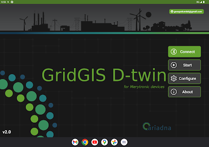
GridGIS D-twin
100+
Downloads

Everyone
info
About this app
GridGIS D-Twin is an app for digitising Low Voltage electrical grids. Specially developed to work with Merytronic portable devices, it provides a comprehensive and efficient solution that allows for automatic storage and transfer of field-collected data. This includes grid topology, electric line layouts, network inventory (transformers, lines..), and barcode information for smart meters, among other things.
With GridGIS D-Twin, data collection in the field is significantly streamlined, avoiding transcription errors and simplifying the transfer of information to the utility's GIS system. All collected data is stored in a file, ensuring data integrity and accuracy.
The app is compatible with the following Merytronic devices:
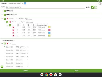
- ILF G2 and ILF G2Pro: Line and phase identifiers.
- MRT-700 and MRT-500: Underground line and pipe locators.
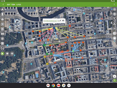
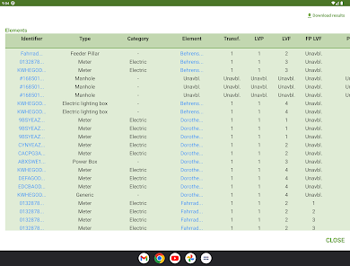
The real-time visualization of identified elements on a map allows for easy access to all meter data with just one click. This includes GPS location, topology data, additional information, and photographs.
Furthermore, the automatic generation functionality of electric line layouts enables the creation of a map with identified lines, which can be edited as needed. It is also possible to complement them with data provided by the tracer devices, MRT-700 or MRT-500.
GridGIS D-Twin provides a comprehensive and user-friendly interface for efficiently managing and updating low-voltage distribution networks.
Additional features of GridGIS D-Twin:
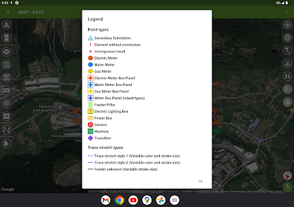
- Identified elements: Secondary substation, electric/water/gas meter, electric/water/gas meter box panel, feeder pillar, power box, electric lighting box, manhole, transition, etc.
- Import/export file formats: *.kmz, *.kml, *.shp, GEOJSON, and *.xls.
- Work progress tracking: Worker identification, date, tracking, etc.
- Underground and/or overhead line tracing
- Together with the MRT-700 or MRT-500 devices, this app is also suitable for locating and tracing metallic or non-metallic underground pipe networks.
Minimum tablet requirements:
- Android version: V7.0 or higher.
- Bluetooth version: V4.2.
- Minimum resolution: 1200x1920.
- 2GB of RAM.
- Support for GPS and GLONASS.
- Compatibility with Google Services.
These features and specifications ensure that GridGIS D-Twin is a versatile and efficient tool for digitizing and managing low voltage distribution networks, providing accurate data collection and integration capabilities.
With GridGIS D-Twin, data collection in the field is significantly streamlined, avoiding transcription errors and simplifying the transfer of information to the utility's GIS system. All collected data is stored in a file, ensuring data integrity and accuracy.
The app is compatible with the following Merytronic devices:
- ILF G2 and ILF G2Pro: Line and phase identifiers.
- MRT-700 and MRT-500: Underground line and pipe locators.
The real-time visualization of identified elements on a map allows for easy access to all meter data with just one click. This includes GPS location, topology data, additional information, and photographs.
Furthermore, the automatic generation functionality of electric line layouts enables the creation of a map with identified lines, which can be edited as needed. It is also possible to complement them with data provided by the tracer devices, MRT-700 or MRT-500.
GridGIS D-Twin provides a comprehensive and user-friendly interface for efficiently managing and updating low-voltage distribution networks.
Additional features of GridGIS D-Twin:
- Identified elements: Secondary substation, electric/water/gas meter, electric/water/gas meter box panel, feeder pillar, power box, electric lighting box, manhole, transition, etc.
- Import/export file formats: *.kmz, *.kml, *.shp, GEOJSON, and *.xls.
- Work progress tracking: Worker identification, date, tracking, etc.
- Underground and/or overhead line tracing
- Together with the MRT-700 or MRT-500 devices, this app is also suitable for locating and tracing metallic or non-metallic underground pipe networks.
Minimum tablet requirements:
- Android version: V7.0 or higher.
- Bluetooth version: V4.2.
- Minimum resolution: 1200x1920.
- 2GB of RAM.
- Support for GPS and GLONASS.
- Compatibility with Google Services.
These features and specifications ensure that GridGIS D-Twin is a versatile and efficient tool for digitizing and managing low voltage distribution networks, providing accurate data collection and integration capabilities.
Updated on
Safety starts with understanding how developers collect and share your data. Data privacy and security practices may vary based on your use, region, and age. The developer provided this information and may update it over time.

No data shared with third parties
Learn more about how developers declare sharing

No data collected
Learn more about how developers declare collection
What’s new
· App performance and styling improvements
App support
phone
Phone number
+34946559270
About the developer
ARIADNA INSTRUMENTS SL
app@ariadnagrid.com
POLIGONO INDUSTRIAL BOROA, PAR 2 C 1
48340 AMOREBIETA-ETXANO
Spain
+34 634 25 27 96


