Footpath Route Planner
In-app purchases
4.8star
5.82K reviews
500K+
Downloads

Everyone
info
About this app
Trace a map with your finger and Footpath will snap to roads and trails. Measure distance and elevation in seconds, then follow along with turn-by-turn voice navigation.
Mix up your routine and plan out a new running route or bike ride, or plan a scenic road trip or multi-day hiking adventure. Footpath allows you to plan custom routes quicker and easier than ever before.
Join millions of adventurers using Footpath Route Planner and pave your own path.
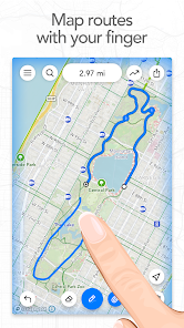
Snap to map
Quickly measure distances by tracing a map with your finger. Footpath will snap to any roads, bike paths, hiking trails, or paths you can find on Footpath's topo maps. Footpath can even snap to rivers and railroads.
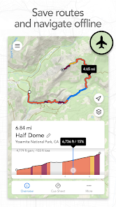
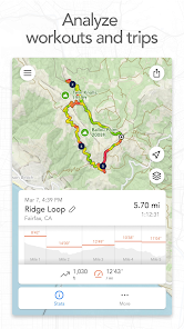
Measure distance and elevation
Know exactly how far and how high you'll travel with an accurate distance measure and detailed elevation profiles. Plan a precise route that matches your mileage goal, or use as a GPS distance tracker if you run without a plan.
Save routes for later
Marathon training or planning a backpacking trip? Sign up for a free account to save up to 5 routes at a time, or save an unlimited number of routes with Footpath Elite.
GPX viewer
Find a cool hiking trail on the web? Import GPX files from anywhere to analyze or save for later.
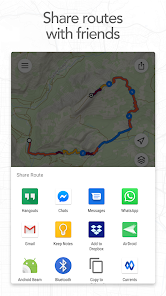
Share routes
Send your routes to friends or workout partners and let them partake in your adventure.
Footpath is designed to work in any country, and for any activity or adventure you can imagine:
• Running, walking, and hiking
• Cycling and mountain biking
• Motorcycling and driving
• Kayaking, canoeing, and standup paddleboarding
• Backcountry skiing
• Sailing
• And many more!
———
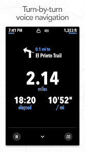
Ready to go the extra mile? Upgrading to a Footpath Elite subscription unlocks the following powerful features:
• Turn-by-turn navigation: Footpath will tell you when to turn with turn-by-turn audio cues
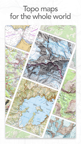
• Premium topo maps & overlays: including USGS Topo Maps, OpenCycleMap, bike paths, avalanche slope shading, elevation contour lines, and many more
• Offline map downloads: follow your route even without cell service
• Organize: save unlimited routes and sort routes into custom lists
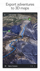
• Export: export GPX files directly to Garmin Connect, Wahoo ELEMNT, COROS, and other apps
• GPS Devices: export TCX and FIT courses for turn-by-turn navigation on select Garmin and Wahoo running watches and cycling computers
———
• For a longer route, try zooming in and mapping your route in multiple segments.
• Tap and hold the map to quickly route between waypoints and POIs.
• Did Footpath snap to the wrong roads? Trace over the incorrect segment to edit, or use the eraser tool.
• Turn off snap to roads (magnet icon) and zoom in to manually trace the map. (Try switching to a satellite layer).
———
We've got a lot planned for Footpath. If you have any suggestions or feedback, or if you run into any issues, please contact us at support@footpathapp.com.
Mix up your routine and plan out a new running route or bike ride, or plan a scenic road trip or multi-day hiking adventure. Footpath allows you to plan custom routes quicker and easier than ever before.
Join millions of adventurers using Footpath Route Planner and pave your own path.
Snap to map
Quickly measure distances by tracing a map with your finger. Footpath will snap to any roads, bike paths, hiking trails, or paths you can find on Footpath's topo maps. Footpath can even snap to rivers and railroads.
Measure distance and elevation
Know exactly how far and how high you'll travel with an accurate distance measure and detailed elevation profiles. Plan a precise route that matches your mileage goal, or use as a GPS distance tracker if you run without a plan.
Save routes for later
Marathon training or planning a backpacking trip? Sign up for a free account to save up to 5 routes at a time, or save an unlimited number of routes with Footpath Elite.
GPX viewer
Find a cool hiking trail on the web? Import GPX files from anywhere to analyze or save for later.
Share routes
Send your routes to friends or workout partners and let them partake in your adventure.
Footpath is designed to work in any country, and for any activity or adventure you can imagine:
• Running, walking, and hiking
• Cycling and mountain biking
• Motorcycling and driving
• Kayaking, canoeing, and standup paddleboarding
• Backcountry skiing
• Sailing
• And many more!
———
Footpath Elite
Ready to go the extra mile? Upgrading to a Footpath Elite subscription unlocks the following powerful features:
• Turn-by-turn navigation: Footpath will tell you when to turn with turn-by-turn audio cues
• Premium topo maps & overlays: including USGS Topo Maps, OpenCycleMap, bike paths, avalanche slope shading, elevation contour lines, and many more
• Offline map downloads: follow your route even without cell service
• Organize: save unlimited routes and sort routes into custom lists
• Export: export GPX files directly to Garmin Connect, Wahoo ELEMNT, COROS, and other apps
• GPS Devices: export TCX and FIT courses for turn-by-turn navigation on select Garmin and Wahoo running watches and cycling computers
———
Tips for mapping routes
• For a longer route, try zooming in and mapping your route in multiple segments.
• Tap and hold the map to quickly route between waypoints and POIs.
• Did Footpath snap to the wrong roads? Trace over the incorrect segment to edit, or use the eraser tool.
• Turn off snap to roads (magnet icon) and zoom in to manually trace the map. (Try switching to a satellite layer).
———
Contact Us
We've got a lot planned for Footpath. If you have any suggestions or feedback, or if you run into any issues, please contact us at support@footpathapp.com.
Updated on
Safety starts with understanding how developers collect and share your data. Data privacy and security practices may vary based on your use, region, and age. The developer provided this information and may update it over time.

No data shared with third parties
Learn more about how developers declare sharing

This app may collect these data types
Location, Personal info and 3 others

Data is encrypted in transit

You can request that data be deleted
Ratings and reviews
4.8
5.58K reviews

DavidPrice PSU
- Flag inappropriate
- Show review history
May 21, 2024
Simple, easy to use, does precisely what I hoped it would do. I've gotten a couple of timeout hiccups, but when I zoom in and/or make shorter entries, I have no problem at all. I particularly like that there are in-town trails on this, too, so I can venture off of my streets into a known local path. Altogether a superior product for my uses, which primarily is relatively accurately estimating the length of a walk or run in areas known to me.
4 people found this review helpful

Eric
- Flag inappropriate
October 6, 2023
The app is OK, not greatest thing but not the worst. We do have the premium version for turn by turn directions. It sometimes will not navigate me correctly when doing repeats around blocks (it cuts me short by one lap). I haven't seen a decent upgrade in over a year where functionalities were added. Would like an option to repeat planned routes. When getting off route it oftentimes takes 30 seconds to send a correction prompt.
3 people found this review helpful

t ega
- Flag inappropriate
September 15, 2023
(this for free version) Ok app, easy to use and good for tracking runs. My main issue is it will occasionally jump distance, meaning it thinks I've gone further than I did. Several times I'll be about 4 minutes in and it will notify me of my first mile; I'm in decent shape, but not that fast. If that were fixed, or I had to ability to manually edit the data on my runs, I wouldn't care all that much.
6 people found this review helpful
Half Mile Labs LLC
September 15, 2023
Thanks for the review! Could you email us at support@footpathapp.com with a screenshot of the recording? We can see what caused the distance glitch, and we can use that to refine the GPS filtering algorithm.
What's new
- Fixed issue with app freezing during login, syncing, and Elite activation
- Bug fixes
If you're enjoying Footpath, please help us out by writing a review on the Play Store.
If you have any problems or suggestions, send us an email at support@footpathapp.com.
- Bug fixes
If you're enjoying Footpath, please help us out by writing a review on the Play Store.
If you have any problems or suggestions, send us an email at support@footpathapp.com.


