
iHunter Alberta
In-app purchases
3.8star
507 reviews
50K+
Downloads

Everyone
info
About this app
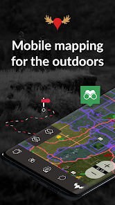
Don't be confused by imitators. iHunter Alberta is the #1 Hunting app for Albertans (with the ratings to back it up)!
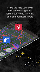
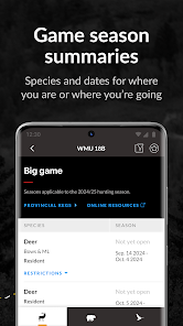
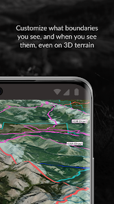
iHunter Alberta gives hunters and outdoor enthusiasts a new view into Alberta's wildlife management units. By overlaying the WMUs on top of base maps, users can see their current location and which WMU they are in. Contribute to the map by adding your own waypoints to keep track of hunting spots, past animal harvests, and landowner contact information. With one of the iHunter subscriptions, dive deeper into specific WMUs to see which big game, predator, and game bird seasons are open.
Features (Most functional offline):
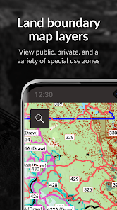
• View Hunting zones overlaid on your choice of map.
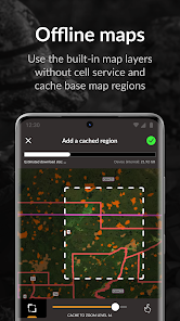
• Multiple satellite, topographic, and road maps included which automatically caching for offline use.
• Add waypoints to the map at your current location, known GPS locations, or by tapping on the map.
• Log in to back up and synchronize waypoints and preferences across devices.
• Utilize the sunrise/sunset calculator to determine legal hunting light at your location or a waypoint.
• Share your current location with friends or family via email or text for easy location tracking requires internet.
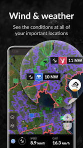
• Display weather at your current location or a waypoint (requires internet).
• First Nations Reserve boundaries.
• Import waypoints and tracks from GPX, KML, and KMZ files.
• Track your position, speed, and altitude; draw over the map; search the map; view recently viewed and favourited items. (Note: Continued use of GPS running in the background can significantly decrease battery life).
With an iHunter Core yearly subscription, you will receive:
• Access to select hunting zones to view summaries of big-game, predators, game birds, and small game seasons (works offline).
• Ability to select regions of base maps and map layers to cache for offline use.
• Unlimited waypoints, tracks, and drawings.
• Capability to add your own TMS and WMS map layers.
• Wind condition display by location (requires internet).
• 3D base maps.
With an iHunter Pro yearly subscription, you will receive:
• All features included in the Core Subscription.
• CarPlay integration.
• iHunter layers in driving navigation for both CarPlay and in-app navigation.
• Additional public and private land layers include over 6000 agricultural leases. See https://www.ihunterapp.com/ for more information.
County Land Ownership Maps: 70 maps to choose from, between $9.99 and $30 CAD each.
iHunter Alberta gives hunters and outdoor enthusiasts a new view into Alberta's wildlife management units. By overlaying the WMUs on top of base maps, users can see their current location and which WMU they are in. Contribute to the map by adding your own waypoints to keep track of hunting spots, past animal harvests, and landowner contact information. With one of the iHunter subscriptions, dive deeper into specific WMUs to see which big game, predator, and game bird seasons are open.
Features (Most functional offline):
• View Hunting zones overlaid on your choice of map.
• Multiple satellite, topographic, and road maps included which automatically caching for offline use.
• Add waypoints to the map at your current location, known GPS locations, or by tapping on the map.
• Log in to back up and synchronize waypoints and preferences across devices.
• Utilize the sunrise/sunset calculator to determine legal hunting light at your location or a waypoint.
• Share your current location with friends or family via email or text for easy location tracking requires internet.
• Display weather at your current location or a waypoint (requires internet).
• First Nations Reserve boundaries.
• Import waypoints and tracks from GPX, KML, and KMZ files.
• Track your position, speed, and altitude; draw over the map; search the map; view recently viewed and favourited items. (Note: Continued use of GPS running in the background can significantly decrease battery life).
With an iHunter Core yearly subscription, you will receive:
• Access to select hunting zones to view summaries of big-game, predators, game birds, and small game seasons (works offline).
• Ability to select regions of base maps and map layers to cache for offline use.
• Unlimited waypoints, tracks, and drawings.
• Capability to add your own TMS and WMS map layers.
• Wind condition display by location (requires internet).
• 3D base maps.
With an iHunter Pro yearly subscription, you will receive:
• All features included in the Core Subscription.
• CarPlay integration.
• iHunter layers in driving navigation for both CarPlay and in-app navigation.
• Additional public and private land layers include over 6000 agricultural leases. See https://www.ihunterapp.com/ for more information.
County Land Ownership Maps: 70 maps to choose from, between $9.99 and $30 CAD each.
Updated on
Safety starts with understanding how developers collect and share your data. Data privacy and security practices may vary based on your use, region and age The developer provided this information and may update it over time.


Ratings and reviews
3.8
480 reviews

Biff 99
- Flag inappropriate
- Show review history
15 January 2024
Helpful app for identifying back road access and crown land. However, many of the landowners maps are not up to date. The one for my WMU has not been updated for several years. It's safer to purchase the map from your county or MD, as some areas identified as crown are now privately owned.
1 person found this review helpful
Inside Outside Studios Inc.
15 January 2024
Hi,
We do our best to provide up to date landowner maps, unfortunately we are typically licensing them in which case we don't have control over the frequency. For maps that we produce in-house, they take months to create, but we're doing our best to speed that up in 2024.

Tycro Eq
- Flag inappropriate
- Show review history
25 April 2023
Need to fix it. When you click on leased land and the person who owns the lease when you try to back out, it reloads the entire province map and you forget where you were looking. You have to zoom back in to try to find it. Very annoying. Update After working with tech support, who was extremely helpful and patient. We found out it was because I had devolper options turned on. Thanks for the help 5 stars
15 people found this review helpful
Inside Outside Studios Inc.
20 April 2023
Hi,
Could you email us at info@ihunterapp.com? This is not at all how the app works so you must be experiencing a bug. It's also worth noting that this isn't happening on any of my devices and nobody else has reported this, so there's a good chance it's something specific to your setup. I'll need you to write on so I can help you resolve the issue.

Liam Kavanagh-Bradette
- Flag inappropriate
- Show review history
15 October 2023
App's confusing and not very clear, once you start to figure it out then it's actually very detailed. But you have to pay for the app, plus $15/map and each WMU is over lapped by sometimes 3 different maps which means I've had to spend $50 this season just to get what I need for a single WMU. Edit: 1) I was mistaken one of the maps I needed was $30 (plus 2 for $15). 2) You're providing the only option for hunters, if you're going to charge for the maps, take the extra time and sell them by WMU.
18 people found this review helpful
Inside Outside Studios Inc.
14 October 2023
None of this should be a surprise. It's outlined in the app description, at ihunterapp.com, and at store.ihunterapp.com. Landowner maps are licensed from the counties and are therefore sold by county. They take considerable time and money to develop, so they can't reasonably be provided for free.
As for clarity, please email us with suggestions.


