
ExitEval
In-app purchases


Everyone
info
100+
Downloads

Everyone
Learn more


About this app
ExitEval is a tool for BASE jumpers to measure exit profiles, analyze GPS tracks, and explore a worldwide database of 2,000+ exits.
EVAL — MEASURE & ANALYZE
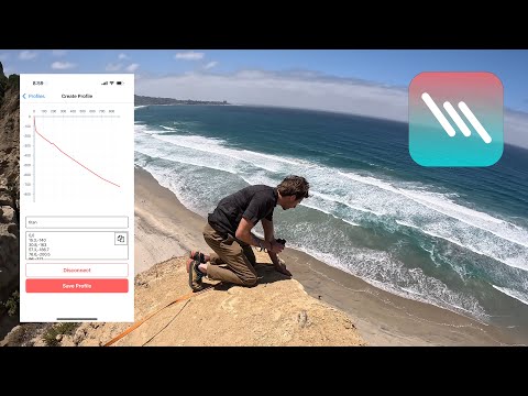
• Create exit profiles with a Uineye Bluetooth laser rangefinder or manual entry
• Import FlySight GPS tracks via file or directly over Bluetooth from FlySight2
• Automatic calculation of 12+ performance metrics: deployment altitude, 1:1 ratio, feather distance, max velocity, and more
• Start summaries showing horizontal distance at key altitude markers (-20m to -400m)
• Compare multiple tracks and profiles on a single interactive chart
• View all your data on a map
EXITS (PRO) — WORLDWIDE EXIT DATABASE
• Browse 2,000+ BASE exits on an interactive map
• Detailed info for each exit: altitude, approach time, jump type, flyable range
• Approach photos, jump videos, and landing zone images
• Community trip reports with real conditions and observations
• Submit new exits, trip reports, and media
• Filter by wingsuit, tracksuit, or slider-off
HARDWARE INTEGRATION
• Uineye laser rangefinder: real-time Bluetooth measurements with haptic feedback
• FlySight2 GPS: wireless track download over BLE (beta)
WORKS OFFLINE
All core measurement and analysis features work without an internet connection. Your data is stored locally on your device.
Free to download. Pro subscription unlocks the full exit database and community features.
EVAL — MEASURE & ANALYZE
• Create exit profiles with a Uineye Bluetooth laser rangefinder or manual entry
• Import FlySight GPS tracks via file or directly over Bluetooth from FlySight2
• Automatic calculation of 12+ performance metrics: deployment altitude, 1:1 ratio, feather distance, max velocity, and more
• Start summaries showing horizontal distance at key altitude markers (-20m to -400m)
• Compare multiple tracks and profiles on a single interactive chart
• View all your data on a map
EXITS (PRO) — WORLDWIDE EXIT DATABASE
• Browse 2,000+ BASE exits on an interactive map
• Detailed info for each exit: altitude, approach time, jump type, flyable range
• Approach photos, jump videos, and landing zone images
• Community trip reports with real conditions and observations
• Submit new exits, trip reports, and media
• Filter by wingsuit, tracksuit, or slider-off
HARDWARE INTEGRATION
• Uineye laser rangefinder: real-time Bluetooth measurements with haptic feedback
• FlySight2 GPS: wireless track download over BLE (beta)
WORKS OFFLINE
All core measurement and analysis features work without an internet connection. Your data is stored locally on your device.
Free to download. Pro subscription unlocks the full exit database and community features.
Updated on
Safety starts with understanding how developers collect and share your data. Data privacy and security practices may vary based on your use, region, and age. The developer provided this information and may update it over time.

No data shared with third parties
Learn more about how developers declare sharing

This app may collect these data types
Personal info, Photos and videos, and App activity

Data is encrypted in transit

You can request that data be deleted
What’s new
ExitEval is now available on Android! Browse exit points, view detailed information, and plan your jumps. Now including a logbook
Everyone
Learn moreApp support
About the developer
jonathan bruno
team@exiteval.org
3734 Curlew St
San Diego, CA 92103-3936
United States


