GPS Field Area Measure
Contains adsIn-app purchases
3.5star
2.97K reviews
1M+
Downloads

Everyone
info


About this app
Improve your measurements with GPS Field Area Measure. This app helps you accurately measure areas and distances, pick locations, and generate KML reports. Whether you're surveying land, planning projects, or simply exploring new territories, This app has you covered.
Key Features:
1. Area Measure: Choose between manual or Auto GPS measurement methods to accurately determine the area of any location. Utilize the interactive map screen to define boundaries, select measurable units, and access additional features such as map type changes and information displays. Save your measured areas along with details such as name, description, group classification, and the option to attach photos and notes for future reference.
-Use Land Type annotation for categorize land as agricultural, residential and commercial.
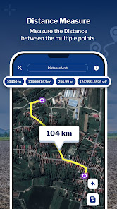
2. Distance Measure: Easily Measure distances using manual or GPS methods. Calculate point-to-point distances on the map screen, view total distances and choose from multiple distance units for convenience. Save your measured distances for quick access and reference along with details such as a name, description, group classification, and the option to attach photos and notes for future reference.
-Use Land Type annotation for categorize land as agricultural, residential and commercial.
-Easily draw plans with support for curved lands or area.
3. Pick Location: Quickly save current or specific locations with customizable details using the Pick Location feature. Store important points of interest for future reference or project planning.
4. Compass: Utilize the built-in compass feature to enhance the accuracy and convenience of your measurements in the field.
5. KML Report: Export KML files to share or analyze your measured data. Generate detailed reports for further analysis or collaboration with team members.
6. Saved List: Access all saved measurements and points of interest in a centralized list format. Organize entries by groups for easy management and retrieval.
7. Field Planner – Map, Draw, Edit & Share Land Projects
- Perfect for farmers, surveyors, or anyone showcasing land!
- Use map view to draw field boundaries, mark land areas, or plan crop/project layouts.
- Edit or customize your crop area from the map and place it on the canvas as an object.
- Create your plan by adding informative stickers or inserting images from your gallery to make it more detailed
- Export your entire plan as a professional PDF to share or present your land project with ease.
8. Unit Converter – Quick Land & Area Calculations
- Convert between various land units easily—acres, hectares, sq. ft, sq. m, and more. Useful for farmers, builders, and planners who need instant, accurate land conversions on the go.
Permissions
- Location - To get current location and display in map and draw path on map based on location.
- Storage(Android 10) & Read images(Above 10) - To get Images and Save your measured areas along with description.
- Camera - To Capture image for Save with Measurement and description.
Key Features:
1. Area Measure: Choose between manual or Auto GPS measurement methods to accurately determine the area of any location. Utilize the interactive map screen to define boundaries, select measurable units, and access additional features such as map type changes and information displays. Save your measured areas along with details such as name, description, group classification, and the option to attach photos and notes for future reference.
-Use Land Type annotation for categorize land as agricultural, residential and commercial.
2. Distance Measure: Easily Measure distances using manual or GPS methods. Calculate point-to-point distances on the map screen, view total distances and choose from multiple distance units for convenience. Save your measured distances for quick access and reference along with details such as a name, description, group classification, and the option to attach photos and notes for future reference.
-Use Land Type annotation for categorize land as agricultural, residential and commercial.
-Easily draw plans with support for curved lands or area.
3. Pick Location: Quickly save current or specific locations with customizable details using the Pick Location feature. Store important points of interest for future reference or project planning.
4. Compass: Utilize the built-in compass feature to enhance the accuracy and convenience of your measurements in the field.
5. KML Report: Export KML files to share or analyze your measured data. Generate detailed reports for further analysis or collaboration with team members.
6. Saved List: Access all saved measurements and points of interest in a centralized list format. Organize entries by groups for easy management and retrieval.
7. Field Planner – Map, Draw, Edit & Share Land Projects
- Perfect for farmers, surveyors, or anyone showcasing land!
- Use map view to draw field boundaries, mark land areas, or plan crop/project layouts.
- Edit or customize your crop area from the map and place it on the canvas as an object.
- Create your plan by adding informative stickers or inserting images from your gallery to make it more detailed
- Export your entire plan as a professional PDF to share or present your land project with ease.
8. Unit Converter – Quick Land & Area Calculations
- Convert between various land units easily—acres, hectares, sq. ft, sq. m, and more. Useful for farmers, builders, and planners who need instant, accurate land conversions on the go.
Permissions
- Location - To get current location and display in map and draw path on map based on location.
- Storage(Android 10) & Read images(Above 10) - To get Images and Save your measured areas along with description.
- Camera - To Capture image for Save with Measurement and description.
Updated on
Safety starts with understanding how developers collect and share your data. Data privacy and security practices may vary based on your use, region, and age. The developer provided this information and may update it over time.

No data shared with third parties
Learn more about how developers declare sharing

No data collected
Learn more about how developers declare collection

Data isn’t encrypted
Data can’t be deleted
Ratings and reviews
3.4
2.92K reviews

Roy Overby
- Flag inappropriate
August 27, 2025
GPS is problematic. many measurements are off by thousands of square feet. Worked great last year. Paid for the service for it to go down hill. needs a function to recalibrate GPS.
28 people found this review helpful

Sheikh Shabir
- Flag inappropriate
October 4, 2025
Does not show current image of land ,i try this app one month before and i found my lands accurate image but now it shows old image.
2 people found this review helpful

Wessels Jordaan
- Flag inappropriate
February 13, 2024
I like the "look and feel" of the app, but in my opinion, it needs a lot more attention to make it user-friendly. Eg. It provides editing of a point (showing 4-way-arrow cursor when the point is double-clicked). But try adjusting the position....the map moves with the cursor and editing impossible. Saving an area....where is the store? Can't store the size or/measurements in the doc dropdown......
150 people found this review helpful
What’s new
What's New:
-Field Planner – Map, Draw, Edit & Share Land Projects
-Unit Converter – Quick Land & Area Calculations
-Use Land Type annotation for categorize land
-Easily draw plans with support for curved lands or area.
-Field Planner – Map, Draw, Edit & Share Land Projects
-Unit Converter – Quick Land & Area Calculations
-Use Land Type annotation for categorize land
-Easily draw plans with support for curved lands or area.
App support
About the developer
DAMINI PUNITKUMAR PATEL
skilltest111@gmail.com
Nr Bus Stand
Dhamasana
Gandhinager, Gujarat 382740
India


