
My Track
Contains adsIn-app purchases
3.6star
14.3K reviews
1M+
Downloads

Everyone
info


About this app
My Track is a small and powerful application to keep track of your route while you go around. The quite complex functionality hides behind a very clear user interface which is easy to understand.
My Track can be very useful for all of your outdoor activities like hiking, bicycle and motorcycle touring, boating, skiing, climbing or sheer driving fun, it can also be used for business.
Have a look at all of these fancy features:
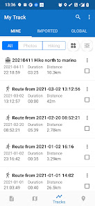
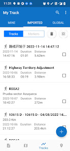
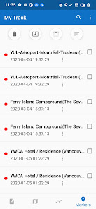
1. Record a route
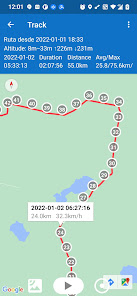
1.1 show current location on Google Map, along with time, duration and distance. even with latitude and longitude.
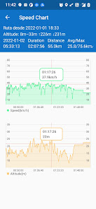
1.2 dynamic chart about speed and altitude.
1.3 route recording, pausing, resuming, saving and listing.
1.4 photos joining with a route automatically, whatever app you use to take photos.
1.5 voice report at predefined frequency of time or distance when recording
1.6 export routes to GPX/KML/KMZ files, or import from your phone or Google Drive.
1.7 sync and restore from Google Drive.
1.8 do stats.
1.9 show multi routes on the map.
1.10 print a route with the map.
2. Share a route
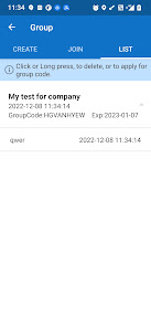
2.1 create a group and invite friends to join this group, you and your friends can share routes in this group.
2.2 share a route globally in this app.
2.3 share a route via web url to social medias, like WhatsApp, FaceBook, Gmail, etc.
2.4 select photos to share with a route.
3. Follow a route
3.1 follow your own route.
3.2 follow others’ shared route.
3.3 follow planned route.
3.4 fly your imagination: share a route in a group, friends in this group can follow this route.
4. Plan a route
4.1 plan a route(driving, bicycling and walking) among multi markers, the planed route can be followed on the map.
5. Markers
5.1 tap on the map to insert a marker, move the map to put the marker on proper position.
5.2 select markers to show on the map.
5.3 markers can be remembered to show next time when you open the app.
5.4 markers can be shared or exported within a route.
5.5 export markers to a KML file.
6. More
6.1 Live broadcast your locations to friends.
6.2 download offline map.
6.3 add map layer, and auto load this layer when the app starts.
6.4 click the map to measure distance, measure area, or to connect points to design a route line.
The app needs such permissions:
1. Storage permission for route saving.
2. Photo permission for joining photos with a route.
3. Location permission for route recording.
4. Internet permission for route sharing.
Attention:
1. Google Play and Google Maps should be installed first.
2. All basic features are free forever, others need subscription after trial period.
3. After 10 days you will see ads, you may pay to remove ads.
4. After 20 days you may click the menu item Store to subscribe.
My Track can be very useful for all of your outdoor activities like hiking, bicycle and motorcycle touring, boating, skiing, climbing or sheer driving fun, it can also be used for business.
Have a look at all of these fancy features:
1. Record a route
1.1 show current location on Google Map, along with time, duration and distance. even with latitude and longitude.
1.2 dynamic chart about speed and altitude.
1.3 route recording, pausing, resuming, saving and listing.
1.4 photos joining with a route automatically, whatever app you use to take photos.
1.5 voice report at predefined frequency of time or distance when recording
1.6 export routes to GPX/KML/KMZ files, or import from your phone or Google Drive.
1.7 sync and restore from Google Drive.
1.8 do stats.
1.9 show multi routes on the map.
1.10 print a route with the map.
2. Share a route
2.1 create a group and invite friends to join this group, you and your friends can share routes in this group.
2.2 share a route globally in this app.
2.3 share a route via web url to social medias, like WhatsApp, FaceBook, Gmail, etc.
2.4 select photos to share with a route.
3. Follow a route
3.1 follow your own route.
3.2 follow others’ shared route.
3.3 follow planned route.
3.4 fly your imagination: share a route in a group, friends in this group can follow this route.
4. Plan a route
4.1 plan a route(driving, bicycling and walking) among multi markers, the planed route can be followed on the map.
5. Markers
5.1 tap on the map to insert a marker, move the map to put the marker on proper position.
5.2 select markers to show on the map.
5.3 markers can be remembered to show next time when you open the app.
5.4 markers can be shared or exported within a route.
5.5 export markers to a KML file.
6. More
6.1 Live broadcast your locations to friends.
6.2 download offline map.
6.3 add map layer, and auto load this layer when the app starts.
6.4 click the map to measure distance, measure area, or to connect points to design a route line.
The app needs such permissions:
1. Storage permission for route saving.
2. Photo permission for joining photos with a route.
3. Location permission for route recording.
4. Internet permission for route sharing.
Attention:
1. Google Play and Google Maps should be installed first.
2. All basic features are free forever, others need subscription after trial period.
3. After 10 days you will see ads, you may pay to remove ads.
4. After 20 days you may click the menu item Store to subscribe.
Updated on
Safety starts with understanding how developers collect and share your data. Data privacy and security practices may vary based on your use, region, and age. The developer provided this information and may update it over time.


Ratings and reviews
3.6
13.9K reviews

Henry Tregillus
- Flag inappropriate
April 20, 2022
Okay, so this app IS better than most other similar apps. Out of everything, it's the most lightweight, which imho, is the most important thing for an app like it. That said...I really wish it was possible to bulk export kml files. I have like fifty that I want to get out, and given that it takes five taps for each...yeah, that's going to be annoying.
3 people found this review helpful
Daniel Qin
April 20, 2022
Thanks, about bulk exportation, your suggestion is valuable for better user experience. I will think about it in the future.

Roger B.
- Flag inappropriate
May 18, 2025
I love this app and have been using it for many years. I deducted one star because of the details page lists altitude in meters and speed (average & max) in km/h. Also, the distance meter on the map list distances in meters. I've tried to switch it to mi/hr and feet to no avail in the settings. All of the other readings are correct in mi/hr and feet. If this was corrected, I would definitely rate this five stars!
9 people found this review helpful
Daniel Qin
May 22, 2025
Hi Roger, Thanks very much for your feedback and your appreciation of this app, I will check this issue and correct it asap. May 23: would you like to upgrade to the latest release V8.1.2 which has fixed the bug?

A Google user
- Flag inappropriate
August 19, 2019
First impressions: seems very similar to Google's former My Tracks. Solid interface, simple to use. One feature I'd like is something that could be used on very long hikes. I tend to go backpacking for a week at a time. I would like, for instance, to set a sampling interval on GPS for every 5 minutes, letting GPS be off between samples to save battery.
42 people found this review helpful
Daniel Qin
August 20, 2019
David, thanks for your review, this app is my works, it's totally different from Google's. You can choose location interval in the app's setting, interval of 1 minute is good for hiking about 50 meters. you may need large capacity mobile power for 1 week's hiking. also, the feature of offline map download is good for hiking.
What’s new
Version 8.5 — Faster, Smoother, Smarter
1. Light & Fast — Removed unnecessary components for a snappier app
2. Rebuilt Screenshot Printing — Clearer, more reliable, hassle-free
3. Full-Screen UI — Optimized for modern devices, cleaner layout
4. Safer & More Reliable — Data handling improved for long-term stability
5. Better Export — Smoother workflow, fewer failures
Upgrade now and feel the difference!
App support
About the developer
Qin ZhiJian
qinzjy@gmail.com
RuiJin Two Road
黄浦区, 上海市
China
200120


