

LiPAD ENERGY Mobile Mapping

4.5star
29 reviews
10K+
Downloads

Everyone
info


About this app
Li.PAD MOBILE MAPPING - THE APP FOR SIGNIFICANT GPS
The solution adopted by dozens of ESCO, Technical Studies and municipalities under the Convention for the Public Lighting SERVICE LIGHT 3 CONSIP.
Using Li.PAD led, 31 August 2017, a census of 187 municipalities with a total of 289.000 points Light and electrical panels. A great result!
Li.PAD Mobile Mapping was founded in 2015 from the need of the companies in the energy sector to equip itself with a tool user friendly for the survey in the field of light points, Switchboards and Network for the purpose of drawing up the state of elements of the plant Done Public lighting, or as reliable and accurate starting point for the production of PRIC (Municipal Lighting Plan).
Easy to use
The use of a device such as the smartphone makes it extremely simple and intuitive mapping work, even on a bicycle.
Low hardware costs
The combination of smartphones and autonomous GPS receiver (optional), limited to a few tens of euro the preparation of the working equipment.
dedicated Functionality
The development of the procedure in close contact with companies active in the energy sector allows timely scheduling of technical characteristics.
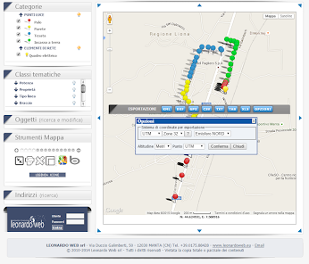
Export DXF, XLS, ...
Twenty-five years of development of mapping applications allow us to communicate with popular GIS and technical software such as QGIS, AutoCAD and ArcGIS.
- FUNCTIONALITY' -
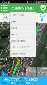
CATEGORY
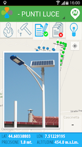
Allows selection of the category of items to be mapped (bins, baskets, expired medicines, used batteries, ...)
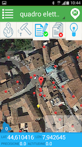
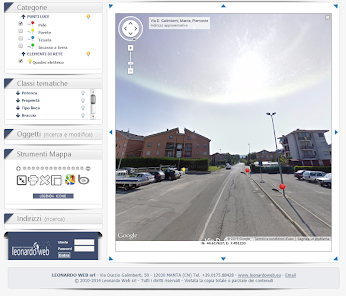
TYPE MAP
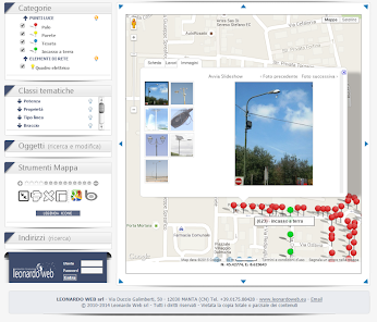
It allows choosing the type of map to represent (street, satellite, mixed).
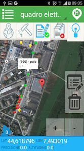
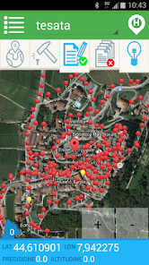
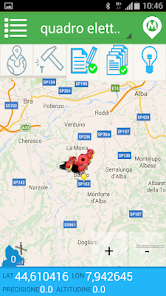
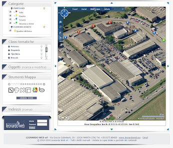
AREA MAP
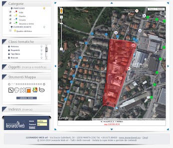
Returns the portion of the territory being mapped with highlighted or not the objects have already been recognized; if necessary, it can be replaced by the compilation tab, or from the maintenance operations carried out by the accompanying images.
COORDINATES
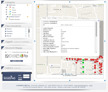
It presents the current position values: latitude, longitude, altitude and accuracy of the detected position.
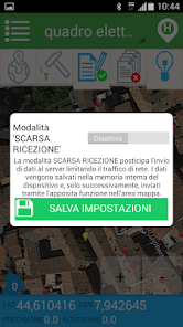
GPS
Activate the external GPS receiver (or internal radio to the device) and the subsequent interactive activities on the area map.
SURVEY
The pressure analyzes the GPS position of the current point and fix its location on the map.
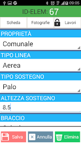
SHEET
Enable or not the opening and subsequent compilation of the information sheet to the point asssociata detected earlier.
COPY
Activate or not the serial nature of the information associated with points detected in consecutio and with the same characteristics.
ACCENDI
Shows or hides the point features found in the current map extent.
- PERMITS REQUIRED -
1. Manage phone calls: When you open the app side menu is returned our phone number to request information or advice; if pressed a call is initiated to our number. In no other case, our application can have access to her calls.
2. Media: In the light of the point card is given the ability to attach the photographs taken by the device which, before being sent to the portal, are saved in the media library; the application can not view or manage other multimedia content than those triggered directly from the Li.PAD.
3. Location: The location is used to manage the GPS device when you view the map.
- SPIN OFF -
The high degree of personalization of the service made it possible to prepare various solutions for surveying in the field or as a fixed station and the subsequent management of information in personal sites.
Li.PAD Garbage - Collection S.U.W. - bins and ecological islands
Li.PAD Covert - Technological networks, wells and network elements
Li.PAD Signage - Road signs and / or posters
Li.PAD Rainbow - Public Roads, landslides and storm damage
Li.PAD Topos - Place names, house numbers.
The solution adopted by dozens of ESCO, Technical Studies and municipalities under the Convention for the Public Lighting SERVICE LIGHT 3 CONSIP.
Using Li.PAD led, 31 August 2017, a census of 187 municipalities with a total of 289.000 points Light and electrical panels. A great result!
Li.PAD Mobile Mapping was founded in 2015 from the need of the companies in the energy sector to equip itself with a tool user friendly for the survey in the field of light points, Switchboards and Network for the purpose of drawing up the state of elements of the plant Done Public lighting, or as reliable and accurate starting point for the production of PRIC (Municipal Lighting Plan).
Easy to use
The use of a device such as the smartphone makes it extremely simple and intuitive mapping work, even on a bicycle.
Low hardware costs
The combination of smartphones and autonomous GPS receiver (optional), limited to a few tens of euro the preparation of the working equipment.
dedicated Functionality
The development of the procedure in close contact with companies active in the energy sector allows timely scheduling of technical characteristics.
Export DXF, XLS, ...
Twenty-five years of development of mapping applications allow us to communicate with popular GIS and technical software such as QGIS, AutoCAD and ArcGIS.
- FUNCTIONALITY' -
CATEGORY
Allows selection of the category of items to be mapped (bins, baskets, expired medicines, used batteries, ...)
TYPE MAP
It allows choosing the type of map to represent (street, satellite, mixed).
AREA MAP
Returns the portion of the territory being mapped with highlighted or not the objects have already been recognized; if necessary, it can be replaced by the compilation tab, or from the maintenance operations carried out by the accompanying images.
COORDINATES
It presents the current position values: latitude, longitude, altitude and accuracy of the detected position.
GPS
Activate the external GPS receiver (or internal radio to the device) and the subsequent interactive activities on the area map.
SURVEY
The pressure analyzes the GPS position of the current point and fix its location on the map.
SHEET
Enable or not the opening and subsequent compilation of the information sheet to the point asssociata detected earlier.
COPY
Activate or not the serial nature of the information associated with points detected in consecutio and with the same characteristics.
ACCENDI
Shows or hides the point features found in the current map extent.
- PERMITS REQUIRED -
1. Manage phone calls: When you open the app side menu is returned our phone number to request information or advice; if pressed a call is initiated to our number. In no other case, our application can have access to her calls.
2. Media: In the light of the point card is given the ability to attach the photographs taken by the device which, before being sent to the portal, are saved in the media library; the application can not view or manage other multimedia content than those triggered directly from the Li.PAD.
3. Location: The location is used to manage the GPS device when you view the map.
- SPIN OFF -
The high degree of personalization of the service made it possible to prepare various solutions for surveying in the field or as a fixed station and the subsequent management of information in personal sites.
Li.PAD Garbage - Collection S.U.W. - bins and ecological islands
Li.PAD Covert - Technological networks, wells and network elements
Li.PAD Signage - Road signs and / or posters
Li.PAD Rainbow - Public Roads, landslides and storm damage
Li.PAD Topos - Place names, house numbers.
Updated on
Safety starts with understanding how developers collect and share your data. Data privacy and security practices may vary based on your use, region, and age. The developer provided this information and may update it over time.

No data shared with third parties
Learn more about how developers declare sharing

This app may collect these data types
Location, Photos and videos, and Device or other IDs

Data isn’t encrypted
Data can’t be deleted