

The Regrid Property App
ଆପ୍ ମଧ୍ୟରେ କ୍ରୟଗୁଡ଼ିକ

4.6star
2.77ହଟି ସମୀକ୍ଷା
100ହ+
ଡାଉନଲୋଡଗୁଡ଼ିକ

ସମସ୍ତେ
info


ଏହି ଆପ୍ ବିଷୟରେ
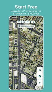
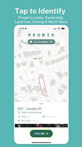
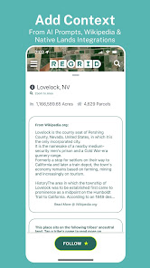
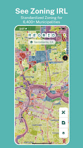
Loved by millions, the Regrid Property App is a map-based solution that unlocks the world of land and property information to anyone with a smart phone. Tap a property to easily view property data and parcel boundaries for 157+ million parcels covering over 99% of the US population.
Easy access to all of the following info (and more!):
- Lot lines / boundaries
- APN/Parcel ID/Regrid UUID
- Property Address
- Property Owner
- Number of acres and square footage of properties
- Sale price and date
- Mailing Address
- Property Value
- Land Use
- Standardized Zoning data
- Vacancy Indicator
For free, you get:
- Access extensive public record property boundaries and details nationwide (no caps or time limit) with just an email address
- Street and satellite basemap toggle
- Search by address or place
- Easy-to-use property map interface
- Ability to share a link to properties of interest
- Ideal for use as a property finder, real estate tool, and as a hunting app to find who owns land.
If you sign up for our $10/month Pro plan, you also get:
- Follow feature: create a list of properties you care about, and get automated updates when things change.
- Additional basemap layers: building footprints, elevation (topo) contours overlaid on property boundaries.
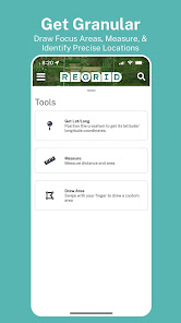
- Measure tool to calculate linear feet, acreage, and square footage of a drawn area
- Overlay owner names and parcel ID on the map
Plus, Pro gets you access to our premium data fields:
- Vacancy
- Land use
- Building footprint data
- Residential & Vacancy indicator
PLUS: Full access to a host of additional mapping tools on our website, [regrid.com](http://regrid.com). Signing up for a Pro account gets you access to both with the same login.
Easy access to all of the following info (and more!):
- Lot lines / boundaries
- APN/Parcel ID/Regrid UUID
- Property Address
- Property Owner
- Number of acres and square footage of properties
- Sale price and date
- Mailing Address
- Property Value
- Land Use
- Standardized Zoning data
- Vacancy Indicator
For free, you get:
- Access extensive public record property boundaries and details nationwide (no caps or time limit) with just an email address
- Street and satellite basemap toggle
- Search by address or place
- Easy-to-use property map interface
- Ability to share a link to properties of interest
- Ideal for use as a property finder, real estate tool, and as a hunting app to find who owns land.
If you sign up for our $10/month Pro plan, you also get:
- Follow feature: create a list of properties you care about, and get automated updates when things change.
- Additional basemap layers: building footprints, elevation (topo) contours overlaid on property boundaries.
- Measure tool to calculate linear feet, acreage, and square footage of a drawn area
- Overlay owner names and parcel ID on the map
Plus, Pro gets you access to our premium data fields:
- Vacancy
- Land use
- Building footprint data
- Residential & Vacancy indicator
PLUS: Full access to a host of additional mapping tools on our website, [regrid.com](http://regrid.com). Signing up for a Pro account gets you access to both with the same login.
ଗତ ଅପଡେଟର ସମୟ
ଡେଭେଲପରମାନେ ଆପଣଙ୍କ ଡାଟାକୁ କିପରି ସଂଗ୍ରହ ଏବଂ ସେୟାର କରନ୍ତି ସେହି ଧାରଣା ସହିତ ସୁରକ୍ଷା ଆରମ୍ଭ ହୁଏ। ଆପଣଙ୍କ ବ୍ୟବହାର, ଅଞ୍ଚଳ ଏବଂ ବୟସ ଆଧାରରେ, ଡାଟା ଗୋପନୀୟତା ଓ ସୁରକ୍ଷା କାର୍ଯ୍ୟପଦ୍ଧତିଗୁଡ଼ିକ ଭିନ୍ନ ହୋଇପାରେ। ଡେଭେଲପର ଏହି ସୂଚନା ପ୍ରଦାନ କରିଛନ୍ତି ଏବଂ ସେ ସମୟାନୁସାରେ ଏହାକୁ ଅପଡେଟ କରିପାରନ୍ତି।


ମୂଲ୍ୟାଙ୍କନ ଓ ସମୀକ୍ଷା
4.6
2.68ହଟି ସମୀକ୍ଷା
ନୂଆ କଣ ଅଛି
- Now, in 3D: Turn on the Terrain Layer and orient yourself based on the nearest mountain.
- 3D Shading: The standard street view now has a touch of 3D shading, so you can get your bearings better.
- Where was I? Now see your most recent searches and return to where you just were.
- 3D Shading: The standard street view now has a touch of 3D shading, so you can get your bearings better.
- Where was I? Now see your most recent searches and return to where you just were.


