
Lowrance: app for anglers
Contains adsIn-app purchases
3.8star
2.47K reviews
100K+
Downloads

Everyone
info


About this app
THE PERFECT FISHING COMPANION
With all the latest and most detailed maps from C-MAP®, the Lowrance App gives you the most accurate charting direct to your mobile device. Now you can manage your favorite waypoints, discover new fishing spots, and plan your next trip with ease. Simply step on-board, sync your data with your Lowrance devices, and spend more time doing what you love – catching fish and logging your favorite spots for future trips.
MANAGE YOUR WAYPOINTS
- Create, store, edit and share your waypoints and fishing spots anytime, anywhere
- Explore new waters and plan great fishing trips in advance
- Offline maps - download your charts and view data, even without mobile coverage or WiFi
DISCOVER NEW FISHING SPOTS AND LAKES
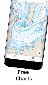
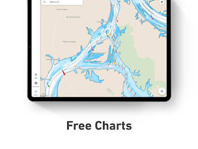
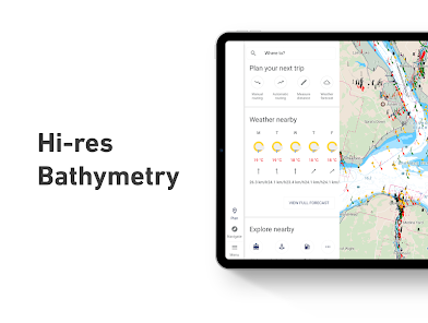
- Latest C-MAP maps - high-resolution bathymetry, custom shading and thousands of Points of Interest, including ramps and fuel
- Autorouting™ - set the best routes to your favorite fishing waypoints automatically
SYNC EASILY WITH YOUR DEVICE
- Save your waypoints, fishing spots, and data with your Lowrance devices when you step on-board, giving you more time to concentrate on catching fish!
- Set Anchor Alerts and notifications for moving outside set locations
REVIEW YOUR DATA
- Sync your App and Lowrance device anytime, on- or off-the-water, so you can always take your latest fishing trip data with you.
The Lowrance App Includes:
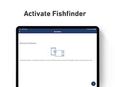
- Activation and Registration of your Lowrance Chartplotter
- FREE C-MAP Chart Viewer
- Autorouting™ – find the best route to your favourite places
- Personal Waypoints
- Track Recording
- Thousands of pre-loaded Points of Interest, including relevant information about marinas, harbours, beaches, shops and much more
- Marine Weather Forecast
- Weather Along the Route
- Weather Overlay
- Chart Personalisation
- Import & Export GPX Files – share your Routes, Tracks or Waypoints with friends
- Measure Distance Tool
Upgrade to Premium to unlock additional features, including:
- Full GPS Functionality
- Offline Map Downloads
- REVEAL Shaded Relief
- High-Resolution Bathymetry
- Custom Depth Shading
- AIS & C-MAP Traffic
Try before you buy… Experience the Lowrance App Premium for yourself, with a free 14-day trial.
Functionality involving direct integration with devices requires NOS software versions of 20.0 and above. Please check for compatibility with your device model:
Elite ti2
Elite FS
HDS Carbon
HDS Live
HDS Pro
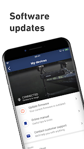
The Lowrance App updates on a continuous basis to make sure you get a great experience and enjoy the most up-to-date fishing maps and functionalities. Be sure to check for updates regularly.
Privacy policy
https://appchart.lowrance.com/privacy.html
Terms of service
https://appchart.lowrance.com/tos.html
With all the latest and most detailed maps from C-MAP®, the Lowrance App gives you the most accurate charting direct to your mobile device. Now you can manage your favorite waypoints, discover new fishing spots, and plan your next trip with ease. Simply step on-board, sync your data with your Lowrance devices, and spend more time doing what you love – catching fish and logging your favorite spots for future trips.
MANAGE YOUR WAYPOINTS
- Create, store, edit and share your waypoints and fishing spots anytime, anywhere
- Explore new waters and plan great fishing trips in advance
- Offline maps - download your charts and view data, even without mobile coverage or WiFi
DISCOVER NEW FISHING SPOTS AND LAKES
- Latest C-MAP maps - high-resolution bathymetry, custom shading and thousands of Points of Interest, including ramps and fuel
- Autorouting™ - set the best routes to your favorite fishing waypoints automatically
SYNC EASILY WITH YOUR DEVICE
- Save your waypoints, fishing spots, and data with your Lowrance devices when you step on-board, giving you more time to concentrate on catching fish!
- Set Anchor Alerts and notifications for moving outside set locations
REVIEW YOUR DATA
- Sync your App and Lowrance device anytime, on- or off-the-water, so you can always take your latest fishing trip data with you.
The Lowrance App Includes:
- Activation and Registration of your Lowrance Chartplotter
- FREE C-MAP Chart Viewer
- Autorouting™ – find the best route to your favourite places
- Personal Waypoints
- Track Recording
- Thousands of pre-loaded Points of Interest, including relevant information about marinas, harbours, beaches, shops and much more
- Marine Weather Forecast
- Weather Along the Route
- Weather Overlay
- Chart Personalisation
- Import & Export GPX Files – share your Routes, Tracks or Waypoints with friends
- Measure Distance Tool
Upgrade to Premium to unlock additional features, including:
- Full GPS Functionality
- Offline Map Downloads
- REVEAL Shaded Relief
- High-Resolution Bathymetry
- Custom Depth Shading
- AIS & C-MAP Traffic
Try before you buy… Experience the Lowrance App Premium for yourself, with a free 14-day trial.
Functionality involving direct integration with devices requires NOS software versions of 20.0 and above. Please check for compatibility with your device model:
Elite ti2
Elite FS
HDS Carbon
HDS Live
HDS Pro
The Lowrance App updates on a continuous basis to make sure you get a great experience and enjoy the most up-to-date fishing maps and functionalities. Be sure to check for updates regularly.
Privacy policy
https://appchart.lowrance.com/privacy.html
Terms of service
https://appchart.lowrance.com/tos.html
Updated on
Safety starts with understanding how developers collect and share your data. Data privacy and security practices may vary based on your use, region, and age. The developer provided this information and may update it over time.

No data shared with third parties
Learn more about how developers declare sharing

This app may collect these data types
Location, Personal info and 4 others

Data is encrypted in transit

You can request that data be deleted
Ratings and reviews
3.7
2.37K reviews

I A
- Flag inappropriate
- Show review history
July 10, 2024
7/9/24. All data got erased out of the blue? All my marked fishing spots are gone. Why?********* Worst app i ever used!! INCLUDE MEASURING 2 POINT DISTANCE RULER! When im choosing wave height, gusts, wind, etc..it changes grounds background color without showing any data,??? Why doesn't it shows wave height? Water temps? And all other data? It shows arrows for wind but doesnt say how fast wind will be wow, im using subscribed version. None of the "how to" works.
8 people found this review helpful
Navico Norway AS
June 26, 2023
Thank you for using our app and for your feedback.
The weather forecast layer is not responding and our team is working on a fix.
You cannot have water temp, as there's no water temp sensor connected with the app.
You do have the option to choose mi instead of ft.

Tom Beauchamp
- Flag inappropriate
- Show review history
May 16, 2024
Spams notifications. Even though push notifications are turned off in the app, it displayed a bunch of notifications trying to sell the premium subscription. Doesn't matter what the subscription does, if the app can't follow it's own settings, there's no way I'm paying this company more money. Help & Feedback section of app hangs when trying to submit feedback.
5 people found this review helpful

Patrick Koch
- Flag inappropriate
- Show review history
May 31, 2022
Why even have an app if everything you tap on it just takes you to a webpage? Nothing about this app feels smooth or intuitive. Very glitchy. For example, i try to click on a button that says "Taylor your chart" but it plots another way point underneath it, on whatever section of map that button happens to be over at the time. Not to mention, all I'm trying to do is register my friggn fishfinder! Feel like everything about this app is just geared towards getting you to buy another product.
36 people found this review helpful
Navico Norway AS
June 7, 2022
Thank you for using our app and for your feedback.
Please contact us from the Help & Feedback option within the app, we'll be happy to help you.
What's new
We've focused on fixing bugs to make sure you're having the smoothest experience! Enjoy the app!


