511 Georgia
Contains ads
2.9star
418 reviews
100K+
Downloads

Everyone
info
About this app
Welcome to the new 511 Georgia app.
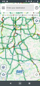
The 511 Georgia mobile app provides real-time road and traffic information to Georgia drivers. Construction, congestion, and other delays are centrally monitored by the many cameras, sensors, and other data available to the Georgia Department of Transportation. Our app will help you plan your route, anticipate delays, and get where you're going faster.
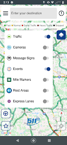
This app features a scrollable, zoomable map that displays:
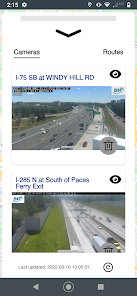
- Traffic Events, such as collisions and other road hazards
- Over 2000 Cameras, frequently updated so you can see the conditions for yourself
- Message Signs
- Rest Areas
- Express Lanes
Other features of the app include:
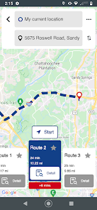
- Route Comparison, enter a destination and get up to 3 routes with travel times displayed
- Route Schedules, you can save a route and set a daily time to have the app run that route before you leave so you can receive automatic notifications
- Drive Mode Alerts, you can just start driving with the app on and you will be notified with an audio alert of any delays on the road ahead of you
- Call 511 – Call in for issues and conditions that you may experience on your route
The 511 Georgia mobile app provides real-time road and traffic information to Georgia drivers. Construction, congestion, and other delays are centrally monitored by the many cameras, sensors, and other data available to the Georgia Department of Transportation. Our app will help you plan your route, anticipate delays, and get where you're going faster.
This app features a scrollable, zoomable map that displays:
- Traffic Events, such as collisions and other road hazards
- Over 2000 Cameras, frequently updated so you can see the conditions for yourself
- Message Signs
- Rest Areas
- Express Lanes
Other features of the app include:
- Route Comparison, enter a destination and get up to 3 routes with travel times displayed
- Route Schedules, you can save a route and set a daily time to have the app run that route before you leave so you can receive automatic notifications
- Drive Mode Alerts, you can just start driving with the app on and you will be notified with an audio alert of any delays on the road ahead of you
- Call 511 – Call in for issues and conditions that you may experience on your route
Updated on
Safety starts with understanding how developers collect and share your data. Data privacy and security practices may vary based on your use, region, and age. The developer provided this information and may update it over time.

No data shared with third parties
Learn more about how developers declare sharing

No data collected
Learn more about how developers declare collection

Data isn’t encrypted

You can request that data be deleted
Ratings and reviews
2.9
388 reviews

A Google user
- Flag inappropriate
November 23, 2019
It comes up with the menu. You make your choice. Then i get a screen that says select your area the rest of the screen is white with red stripe across the bottom of the screen. It goes no where from thete. It used to work but was in need of a lot of work before this happened. someone should make this app work. The concept is great. It needs better functions. The interactive map takes forever to load. And when it does load, theres no road names or a "my location" spot on the interactive map.
16 people found this review helpful
IBI Group Mobile
November 27, 2019
Hi, Justjme Woodoo. Thanks for the feedback. To turn on location lock, tap the compass icon on the interactive map. You can toggle this again to move the map around freely. As far as the white screen issue, could you email us some details at GA511AppFeedback@iteris.com? Uninstalling and reinstalling may help. Have a safe and happy Thanksgiving!

Unk B
- Flag inappropriate
- Show review history
October 5, 2021
Omg. They literally just messed up a perfectly good app. The new map looks cluttered and low-res. Before, you could click a camera and it would instantly play live and then you could just swipe to the next camera feed. Now you have to click play on each camera icon and you can't go to the next camera without going back out to the map. Old app me please!
28 people found this review helpful

D Dan
- Flag inappropriate
- Show review history
June 23, 2022
App used to work reasonably well, "updated" interface is cartoonish (guess that appeals to the kids) but far less useful. Majority of camera feeds do not work, interface overly crowded/hard to wade through the (cartoon) graphics. All the hallmarks of a government-funded app. Clunky, cartoonish and marginally functional at best. Embarrassing for Georgia. Take note of the defensive,mumbling responses from the developers, who should be replaced.
12 people found this review helpful
What's new
The new 511 Georgia app includes the following new features and improvements:
- Minor UI and design tweaks for better readability.
- Performance optimization, bug fixes and general stability improvements.
Thank you for using Georgia 511! As always, we appreciate your feedback. If you encounter any issues or have suggestions, feel free to reach out to our support team.
Safe travels!


