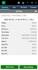
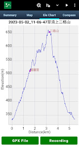
The core function of Green Tracks reads and analyzes the GPX, KML, KMZ and other track files in the mobile phone, and draws the analyzed content on the map. With the GPS satellite positioning, the user can know where he is in the track line. Reduce the risk of getting lost and can be used as a reference for outdoor activities such as mountain climbing and hiking.
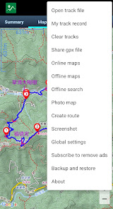
•Supports Mapsforge offline map files You can download the OpenAndroMaps world map directly in Green Tracks.
•Offline search Install Mapsforge's POI file to search for points of interest offline.
•Supports offline maps in MBTiles format Users can use Mobile Atlas Creator (MOBAC) to create MBTiles offline maps and select the MBTiles SQLite format. For offline map production methods, please refer to https://sky.greentracks.app/?p=2895
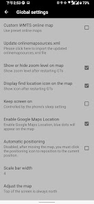
•Online map You can use Google Road Map, Google Satellite Map, Google Hybrid Map, Google Terrain Map.
•Record tracks Use Green Tracks to record your own journey. The recorded track lines can also be edited or merged, and the records can be saved in file formats such as GPX, KML or KMZ through the export function.
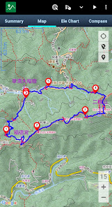
•Supports various types of track file formats Green Tracks can parse track files in GPX, KML, KMZ and other file formats and display them on the map.
•Route planning Supports BRouter, you can plan routes in Green Tracks and export them as GPX, KML or KMZ.
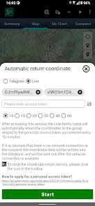
•Automatically return coordinates By automatically returning coordinates or manually returning coordinates (network signal is required), those left behind can keep track of the traces at any time.
•Mark location The coordinates reported by family members or friends can be marked on the map automatically or manually, making it easier to track their whereabouts.
•Coordinate conversion WGS84 coordinate format conversion and TWD67, TWD97, UTM and other geodetic datum conversions.
•Off-track Alarm During the process of recording the track, combined with the GPX file, you can use this function to avoid taking the wrong path.
•Backup and restore Backup and restore self-recorded track records.
•Support HGT files The HGT elevation file can be used to correct the altitude and improve the accuracy of the altitude.
•Photo map Scan the photos on your phone and display them on the map to recall all the memories you took when you took them.
•Share your tracks You can share your GPX records with other users, or download GPX files for tracking.
• Screenshot Take screenshots of the "Summary", "Map" and "Ele Chart" of the walking track and collage them into one photo for easy sharing on various online platforms.
•Supports overlapping maps Green Tracks supports offline maps stacked on top of online maps, and offline maps stacked on top of offline maps.
•Supports Google Earth tour files The records of the Green Tracks can be exported to kml or kmz files and provided with Google Earth Pro version (PC version) to record dynamic track videos. Video reference https://youtu.be/f-qHKSfzY9U?si=MO7eQQVSHEyZ57DK Our website https://en.greentracks.app/
Updated on
Apr 27, 2024
Travel & Local
Data safety
arrow_forward
Safety starts with understanding how developers collect and share your data. Data privacy and security practices may vary based on your use, region, and age. The developer provided this information and may update it over time.
This app may share these data types with third parties
Location
This app may collect these data types
Personal info, Files and docs, and Device or other IDs
Data is encrypted in transit
You can request that data be deleted
See details
'> -->
Not Found
We're sorry, the requested URL was not found on this server.